Login
Register


RTN
Raton Municipal/Crews Field Airport
Official FAA Data Effective 2026-02-19 0901Z
Chart Supplement

VFR Chart of KRTN
Sectional Charts at SkyVector.com
IFR Chart of KRTN
Enroute Charts at SkyVector.com
Location Information for KRTN
Coordinates: N36°44.55' / W104°30.10'Located 10 miles SW of Raton, New Mexico on 1280 acres of land. View all Airports in New Mexico.
Surveyed Elevation is 6352 feet MSL.
Operations Data
|
|
Airport Communications
| ASOS: | 118.375 Tel. 575-303-2003 |
|---|---|
| CTAF: | 122.800 |
| UNICOM: | 122.800 |
| ASOS at TAD (32.3 N): | 119.025 719-845-1156 |
| AWOS-3 at AXX (42.6 SW): | 118.025 575-377-0526 |
| AWOS-3PT at N24 (52.8 W): | 118.2 575-586-2019 |
- APCH/DEP SVC PRVDD BY ALBUQUERQUE ARTCC ON FREQS 132.8/346.35 (RATON RCAG).
Nearby Navigation Aids
|
| ||||||||||||||||||||||||||||||||||||


Runway 02/20
| Dimensions: | 7615 x 75 feet / 2321 x 23 meters | |
|---|---|---|
| Surface: | Asphalt in Excellent Condition | |
| Weight Limits: | 25 /F/D/X/T, S-18 | |
| Edge Lighting: | Medium Intensity | |
| Runway 02 | Runway 20 | |
| Coordinates: | N36°44.05' / W104°30.67' | N36°45.09' / W104°29.80' |
| Elevation: | 6332.3 | 6348.6 |
| Traffic Pattern: | Left | Left |
| Runway Heading: | 34° True | 214° True |
| Markings: | Non-Precision Instrument in good condition. | Non-Precision Instrument in good condition. |
| Glide Slope Indicator | P2L (3.00° Glide Path Angle) | |
Runway 07/25
| Dimensions: | 4425 x 75 feet / 1349 x 23 meters | |
|---|---|---|
| Surface: | Asphalt in Good Condition | |
| Weight Limits: | 6 /F/D/X/T, S-12 | |
| Edge Lighting: | Medium Intensity | |
| Runway 07 | Runway 25 | |
| Coordinates: | N36°44.43' / W104°30.32' | N36°44.58' / W104°29.43' |
| Elevation: | 6342.0 | 6309.7 |
| Traffic Pattern: | Left | Left |
| Runway Heading: | 78° True | 258° True |
| Markings: | Basic in good condition. | Non-Precision Instrument in good condition. |
Services Available
| Fuel: | 100LL (blue), Jet A-1+ |
|---|---|
| Transient Storage: | Hangars,Tiedowns CALL 575-445-3076 FOR AVBLTY. |
| Airframe Repair: | MINOR |
| Engine Repair: | MINOR |
| Bottled Oxygen: | HIGH/LOW |
| Bulk Oxygen: | NOT AVAILABLE |
Ownership Information
| Ownership: | Publicly owned | |
|---|---|---|
| Owner: | CITY OF RATON | |
| BOX 19 | ||
| RATON, NM 87740 | ||
| 575-445-9551 | ||
| Manager: | DUSTY LONGWILL | |
| HCR 62 BOX 19 | ||
| RATON, NM 87740 | ||
| 575-445-3076 | 575-707-2225. | |
Other Remarks
- THIS AIRPORT HAS BEEN SURVEYED BY THE NATIONAL GEODETIC SURVEY.
- RWY 02/20 UNLGTD STWY; 240 FT S END; 150 FT NORTH END.
- COMPASS ROSE ON RAMP.
- FOR CD CTC ALBUQUERQUE ARTCC AT 505-856-4861.
- ACTVT PAPI RWY 02; MIRL RWY 02/20 & 07/25 - CTAF. DUSK-2300 PAPI RWY 02; MIRL RWY 02/20 & 07/25 PRESET LOW INTST; INCR INTST - CTAF.
Weather Minimums
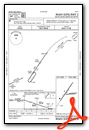
Instrument Approach Procedure (IAP) Charts

Nearby Airports with Instrument Procedures
| ID | Name | Heading / Distance | ||
|---|---|---|---|---|
 |
KTAD | Perry Stokes Airport | 013° | 31.9 |
|
KAXX | Angel Fire Airport | 243° | 42.7 |
|
4V1 | Spanish Peaks Airfield Airport | 346° | 58.8 |
|
KSKX | Taos Regional Airport | 253° | 59.2 |
|
KCAO | Clayton Municipal Airpark Airport | 104° | 67.7 |
|
KLVS | Las Vegas Municipal Airport | 205° | 72.2 |
|
KALS | San Luis Valley Regional/Bergman Field Airport | 302° | 77.6 |
|
KMVI | Monte Vista Municipal Airport | 302° | 87.8 |
|
KLHX | La Junta Municipal Airport | 030° | 91.6 |
|
KPUB | Pueblo Memorial Airport | 000° | 92.7 |
|
17K | Boise City Airport | 088° | 96.0 |
|
8V7 | Springfield Municipal Airport | 064° | 100.1 |
Airport Images
Do you have a recent image of this airport? Upload it here!


