Login
Register


LVS
Las Vegas Municipal Airport
Official FAA Data Effective 2026-02-19 0901Z
Chart Supplement

VFR Chart of KLVS
Sectional Charts at SkyVector.com
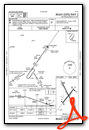
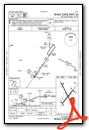
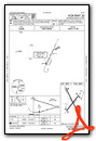
IFR Chart of KLVS
Enroute Charts at SkyVector.com
Location Information for KLVS
Coordinates: N35°39.25' / W105°8.54'Located 05 miles NE of Las Vegas, New Mexico on 1300 acres of land. View all Airports in New Mexico.
Surveyed Elevation is 6877 feet MSL.
Operations Data
|
|
Airport Communications
| ASOS: | 118.525 Tel. 505-454-4645 |
|---|---|
| UNICOM: | 122.800 |
| CTAF: | 122.800 |
| ASOS at SAF (46.3 W): | 505-474-3117 |
| ATIS at SAF (46.3 W): | 128.55 |
| AWOS-3 at AXX (46.7 N): | 118.025 575-377-0526 |
- APCH/DEP SVC PRVDD BY ALBUQUERQUE ARTCC (ZAB) ON FREQS 132.8/346.35 (SANDIA MOUNTAIN RCAG).
Nearby Navigation Aids
|
| ||||||||||||||||||||||||||||||||||||||||||


Runway 14/32
| Dimensions: | 8199 x 75 feet / 2499 x 23 meters | |
|---|---|---|
| Surface: | Asphalt in Good Condition | |
| Weight Limits: | 7 /F/D/X/T, S-20 | |
| Edge Lighting: | Medium Intensity | |
| Runway 14 | Runway 32 | |
| Coordinates: | N35°39.86' / W105°8.93' | N35°38.67' / W105°8.14' |
| Elevation: | 6839.9 | 6877.2 |
| Traffic Pattern: | Left | Left |
| Runway Heading: | 152° True | 332° True |
| Markings: | Non-Precision Instrument in fair condition. | Non-Precision Instrument in fair condition. |
| Glide Slope Indicator | P2L (3.00° Glide Path Angle) | P2L (3.00° Glide Path Angle) |
Runway 02/20
| Dimensions: | 5006 x 75 feet / 1526 x 23 meters | |
|---|---|---|
| Surface: | Asphalt in Good Condition | |
| Weight Limits: | 8 /F/D/X/T, S-20 | |
| Edge Lighting: | Medium Intensity | |
| Runway 02 | Runway 20 | |
| Coordinates: | N35°38.90' / W105°8.85' | N35°39.57' / W105°8.27' |
| Elevation: | 6866.0 | 6860.5 |
| Traffic Pattern: | Left | Left |
| Runway Heading: | 35° True | 215° True |
| Markings: | Non-Precision Instrument in good condition. | Non-Precision Instrument in good condition. |
| Glide Slope Indicator | P2L (3.00° Glide Path Angle) | P2L (3.00° Glide Path Angle) |
| Approach Lights: | ODALS Omnidirectional Approach Lighting System OTS INDEFLY. | ODALS Omnidirectional Approach Lighting System OTS INDEFLY. |
Services Available
| Fuel: | 100LL (blue), Jet A-1 |
|---|---|
| Transient Storage: | Tiedowns |
| Airframe Repair: | NOT AVAILABLE |
| Engine Repair: | NOT AVAILABLE |
| Bottled Oxygen: | NOT AVAILABLE |
| Bulk Oxygen: | NOT AVAILABLE |
Ownership Information
| Ownership: | Publicly owned | |
|---|---|---|
| Owner: | CITY OF LAS VEGAS | |
| 1700 NORTH GRAND | ||
| LAS VEGAS, NM 87701 | ||
| 505-454-1401 | ||
| Manager: | JOHN ARAGON | |
| 910 AIRPORT ROAD | ||
| LAS VEGAS, NM 87701 | ||
| 505-454-0881 | ||
Other Remarks
- BIRDS ON & INVOF ARPT.
- NMRS HOLD & DRCTN SIGNS OTS.
- FOR CD IF UNA TO CTC ON FSS FREQ, CTC ALBUQUERQUE ARTCC AT 505-856-4561.
- FUEL 24 HR SELF SVC WITH CREDIT CARD.
- ACTVT PAPI RWY 02, 20, 14, 32; MIRL RWY 02/20 & 14/32 - CTAF.
Weather Minimums
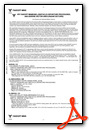
Instrument Approach Procedure (IAP) Charts

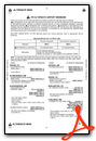
Nearby Airports with Instrument Procedures
| ID | Name | Heading / Distance | ||
|---|---|---|---|---|
 |
KSAF | Santa Fe Regional Airport | 267° | 46.4 |
|
KAXX | Angel Fire Airport | 351° | 46.6 |
|
KSKX | Taos Regional Airport | 331° | 54.3 |
|
KLAM | Los Alamos Airport | 284° | 56.6 |
|
0E0 | Moriarty Municipal Airport | 226° | 58.4 |
|
KRTN | Raton Municipal/Crews Field Airport | 025° | 72.2 |
|
KTCC | Tucumcari Municipal Airport | 110° | 80.6 |
|
KABQ | Albuquerque International Sunport Airport | 243° | 80.8 |
|
KAEG | Double Eagle II Airport | 249° | 86.6 |
|
KBRG | Belen Regional Airport | 234° | 102.9 |
|
KTAD | Perry Stokes Airport | 021° | 103.7 |
|
KCAO | Clayton Municipal Airpark Airport | 063° | 107.9 |
Airport Images

By: 2flaps


