Login
Register


SWT
Seward Municipal Airport
Official FAA Data Effective 2026-01-22 0901Z
Chart Supplement

VFR Chart of KSWT
Sectional Charts at SkyVector.com
IFR Chart of KSWT
Enroute Charts at SkyVector.com
Location Information for KSWT
Coordinates: N40°51.88' / W97°6.55'Located 03 miles S of Seward, Nebraska on 336 acres of land. View all Airports in Nebraska.
Surveyed Elevation is 1505 feet MSL.
Operations Data
|
|
Airport Communications
| OMAHA APPROACH: | 124.0 270.3 |
|---|---|
| OMAHA DEPARTURE: | 124.0 270.3 |
| CTAF: | 122.800 |
| UNICOM: | 122.800 |
| ATIS at LNK (15.9 E): | 118.05 |
| ASOS at LNK (15.9 E): | 402-417-0560 |
| AWOS-3 at JYR (23.5 W): | 124.175 402-362-3785 |
Nearby Navigation Aids
|
| ||||||||||||||||||||||||||||||||||||||||||||||||||||||||||||


Runway 16/34
| Dimensions: | 4200 x 75 feet / 1280 x 23 meters | |
|---|---|---|
| Surface: | Concrete in Good Condition | |
| Weight Limits: | S-30, D-45, ST-90 | |
| Edge Lighting: | Medium Intensity | |
| Runway 16 | Runway 34 | |
| Coordinates: | N40°52.16' / W97°6.57' | N40°51.47' / W97°6.49' |
| Elevation: | 1494.0 | 1505.4 |
| Traffic Pattern: | Left | Left |
| Runway Heading: | 174° True | 354° True |
| Markings: | Non-Precision Instrument in good condition. | Non-Precision Instrument in good condition. |
| Glide Slope Indicator | P2L (3.00° Glide Path Angle) | P2L (3.00° Glide Path Angle) |
Runway 04/22
| Dimensions: | 3400 x 150 feet / 1036 x 46 meters | |
|---|---|---|
| Surface: | Turf in Good Condition | |
| Runway 04 | Runway 22 | |
| Coordinates: | N40°51.78' / W97°6.85' | N40°52.16' / W97°6.31' |
| Elevation: | 1501.0 | 1490.0 |
| Traffic Pattern: | Left | Left |
| Runway Heading: | 47° True | 227° True |
Services Available
| Fuel: | 100LL (blue), Jet-A |
|---|---|
| Transient Storage: | Hangars,Tiedowns |
| Airframe Repair: | MAJOR |
| Engine Repair: | MAJOR |
| Bottled Oxygen: | NONE |
| Bulk Oxygen: | NONE |
Ownership Information
| Ownership: | Publicly owned | |
|---|---|---|
| Owner: | SEWARD AIRPORT AUTHORITY | MARVIN SIEFERT, AIRPORT AUTHORITY CHAIRMAN. |
| 1251 280TH RD | ||
| SEWARD, NE 68434-0278 | ||
| 402-643-2125 | ||
| Manager: | GREG AND TERRI WHISLER | |
| BOX 278 | ||
| SEWARD, NE 68434-0278 | ||
| 402-643-2125 | ||
Other Remarks
- FOR CD CTC OMAHA APCH AT 402-682-4395.
- 23 FT ROAD 1225 FT FM RWY END XS CNTRLN.
- 13 FT ROAD 730 FT FM RWY END XS CNTRLN.
- 0LL SELF SVC AVBL H24.
- ACTVT MIRL RWY 16/34; PAPI RWY 16 & 34; WINDSOCK - CTAF.
Weather Minimums

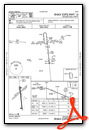
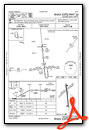
Instrument Approach Procedure (IAP) Charts
Nearby Airports with Instrument Procedures
| ID | Name | Heading / Distance | ||
|---|---|---|---|---|
 |
KLNK | Lincoln Airport | 092° | 16.0 |
|
KCEK | Crete Municipal Airport | 150° | 17.0 |
|
93Y | David City Municipal Airport | 358° | 21.9 |
|
KJYR | York Municipal Airport | 274° | 23.5 |
|
KFMZ | Fairmont State Airport | 231° | 27.0 |
|
KAHQ | Wahoo Municipal Airport | 045° | 32.5 |
|
KOLU | Columbus Municipal Airport | 343° | 36.6 |
|
KBIE | Beatrice Municipal Airport | 154° | 37.5 |
|
KAUH | Aurora Municipal/Al Potter Field Airport | 272° | 40.3 |
|
KFBY | Fairbury Municipal Airport | 183° | 41.0 |
|
KFET | Fremont Municipal Airport | 037° | 44.1 |
|
07K | Central City Municipal/Larry Reineke Field Airport | 289° | 45.3 |
Airport Images
Do you have a recent image of this airport? Upload it here!


