Login
Register


USE
Fulton County Airport
Official FAA Data Effective 2026-01-22 0901Z
Chart Supplement

VFR Chart of KUSE
Sectional Charts at SkyVector.com
IFR Chart of KUSE
Enroute Charts at SkyVector.com
Location Information for KUSE
Coordinates: N41°36.59' / W84°7.63'Located 04 miles N of Wauseon, Ohio on 42 acres of land. View all Airports in Ohio.
Surveyed Elevation is 780 feet MSL.
Operations Data
|
|
Airport Communications
| AWOS-3P: | 127.375 Tel. 419-335-0775 |
|---|---|
| TOLEDO APPROACH: | 134.35 317.55 |
| TOLEDO DEPARTURE: | 134.35 317.55 |
| CTAF: | 123.000 |
| UNICOM: | 123.000 |
| ATIS at TOL (14.4 E): | 118.75 |
| ASOS at TOL (14.5 E): | 419-210-1094 |
| ASOS at ADG (15.6 N): | 118.825 517-265-9089 |
Nearby Navigation Aids
|
| ||||||||||||||||||||||||||||||||||||||||||||||||||||||||||||


Runway 09/27
| Dimensions: | 3882 x 75 feet / 1183 x 23 meters | |
|---|---|---|
| Surface: | Asphalt in Good Condition | |
| Weight Limits: | S-30 | |
| Edge Lighting: | Medium Intensity | |
| Runway 09 | Runway 27 | |
| Coordinates: | N41°36.62' / W84°7.96' | N41°36.63' / W84°7.11' |
| Elevation: | 778.8 | 770.0 |
| Traffic Pattern: | Left | Left |
| Runway Heading: | 89° True | 269° True |
| Markings: | Non-Precision Instrument in good condition. | Non-Precision Instrument in good condition. |
| Glide Slope Indicator | P4L (3.00° Glide Path Angle) | P4R (3.00° Glide Path Angle) |
| REIL: | Yes | Yes |
| Obstacles: | 15 ft Road 457 ft from runway | |
Runway 18/36
| Dimensions: | 2115 x 75 feet / 645 x 23 meters | |
|---|---|---|
| Surface: | Asphalt-Turf in Good Condition 359 FT OF CNTR SECTION ASPH, NORTH 270 FT TURF, SOUTH 1328 FT TURF. | |
| Runway 18 | Runway 36 | |
| Coordinates: | N41°36.70' / W84°7.81' | N41°36.35' / W84°7.81' |
| Elevation: | 777.0 | 780.6 |
| Traffic Pattern: | Left | Left |
| Runway Heading: | 180° True | 360° True |
| Markings: | in good condition. | in good condition. |
| Obstacles: | 66 ft Tree 1161 ft from runway, 229 ft right of center | |
Services Available
| Fuel: | 100LL (blue), Jet A+, UL94 |
|---|---|
| Transient Storage: | Hangars,Tiedowns PRIOR CDN RQRD. |
| Airframe Repair: | NONE |
| Engine Repair: | NONE |
| Bottled Oxygen: | NONE |
| Bulk Oxygen: | NONE |
| Other Services: | AIR AMBULANCE SERVICES,PILOT INSTRUCTION |
Ownership Information
| Ownership: | Publicly owned | |
|---|---|---|
| Owner: | FULTON COUNTY | |
| 152 S FULTON ST STE 270 | ||
| WAUSEON, OH 43567-3308 | ||
| 419-337-9255 | ||
| Manager: | MASON MARCONI | |
| 9460 COUNTY ROAD 14 | ||
| WAUSEON, OH 43567-9670 | ||
| 419-335-3993 | ||
Other Remarks
- DEER & BIRDS ON & INVOF ARPT.
- RESTROOM ACCESS, UNICOM.
- FOR CD CTC TOLEDO APCH AT 419-865-1495.
- RWY 27 CLIMB STRAIGHT OUT TO 1300 MSL.
- TURF PTN MKD WITH WHITE CONES.
- TURF PTN MKD WITH WHITE CONES.
- 0LL 100LL & UL94 AVBL H24 SELF SVC VIA CREDIT CARD.
- TIEDOWN ROPES NOT PRVDD.
- ACTVT REIL RWY 09 & 27; PAPI RWY 09 & 27; MIRL RWY 09/27 - CTAF.
Weather Minimums


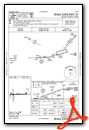
Instrument Approach Procedure (IAP) Charts

Nearby Airports with Instrument Procedures
| ID | Name | Heading / Distance | ||
|---|---|---|---|---|
 |
7W5 | Henry County Airport | 169° | 14.4 |
|
KTOL | Eugene F Kranz Toledo Express Airport | 095° | 14.4 |
|
KADG | Lenawee County Airport | 008° | 15.6 |
|
0G6 | Williams County Airport | 243° | 19.1 |
|
KDFI | Defiance Memorial Airport | 219° | 21.3 |
|
KDUH | Toledo Suburban Airport | 070° | 22.5 |
|
1G0 | Wood County Airport | 120° | 26.0 |
|
KJYM | Hillsdale Municipal Airport | 312° | 27.8 |
|
KTDZ | Toledo Exec Airport | 095° | 29.2 |
|
KOWX | Putnam County Airport | 169° | 35.1 |
|
KTTF | Custer Airport | 057° | 36.9 |
|
KARB | Ann Arbor Municipal Airport | 024° | 40.5 |
Airport Images

By: pilot409


