Login
Register


DFI
Defiance Memorial Airport
Official FAA Data Effective 2026-02-19 0901Z
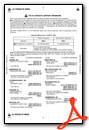
Chart Supplement

VFR Chart of KDFI
Sectional Charts at SkyVector.com
IFR Chart of KDFI
Enroute Charts at SkyVector.com
Location Information for KDFI
Coordinates: N41°20.25' / W84°25.73'Located 04 miles NW of Defiance, Ohio on 314 acres of land. View all Airports in Ohio.
Surveyed Elevation is 706 feet MSL.
Operations Data
|
|
Airport Communications
| ASOS: | 121.425 Tel. 419-658-2301 |
|---|---|
| TOLEDO APPROACH: | 134.35 307.0 |
| TOLEDO DEPARTURE: | 134.35 307.0 |
| UNICOM: | 122.700 |
| CTAF: | 122.700 |
| AWOS-3P at USE (21.3 NE): | 127.375 419-335-0775 |
| AWOS-3 at OWX (27.0 SE): | 120.525 419-523-4151 |
| AWOS-3P at GWB (28.2 W): | 124.15 260-925-8225 |
Nearby Navigation Aids
|
| ||||||||||||||||||||||||||||||||||||||||||||||||||||||||||||


Runway 12/30
| Dimensions: | 4199 x 72 feet / 1280 x 22 meters | |
|---|---|---|
| Surface: | Asphalt in Good Condition | |
| Edge Lighting: | Medium Intensity | |
| Runway 12 | Runway 30 | |
| Coordinates: | N41°20.40' / W84°26.14' | N41°20.10' / W84°25.31' |
| Elevation: | 706.9 | 699.5 |
| Traffic Pattern: | Left | Left |
| Runway Heading: | 115° True | 295° True |
| Markings: | Non-Precision Instrument in good condition. | Non-Precision Instrument in good condition. |
| Glide Slope Indicator | P4L (3.00° Glide Path Angle) | PSIL |
| REIL: | Yes | Yes |
| Obstacles: | 60 ft Trees 1445 ft from runway, 103 ft left of center | 75 ft Trees 1385 ft from runway, 252 ft right of center |
Services Available
| Fuel: | 100LL (blue), Jet A+ |
|---|---|
| Transient Storage: | Hangars,Tiedowns PRIOR CDN RQRD FOR HNGR. |
| Airframe Repair: | MAJOR |
| Engine Repair: | MAJOR |
| Bottled Oxygen: | LOW |
| Bulk Oxygen: | NONE |
| Other Services: | PILOT INSTRUCTION,AIRCRAFT RENTAL |
Ownership Information
| Ownership: | Publicly owned | |
|---|---|---|
| Owner: | BOARD OF CO COMMISSIONERS | |
| 500 COURT ST STE A | ||
| DEFIANCE, OH 43512-2171 | ||
| 419-782-4761 | ||
| Manager: | TONY SAXTON | TONY@TAS-AVIATION.COM. |
| 20399 AIRPORT RD | ||
| DEFIANCE, OH 43512-6763 | ||
| 419-658-4444 | ||
Other Remarks
- DEER, BIRDS, & WILDLIFE ON & INVOF ARPT.
- FOR CD CTC TOLEDO APCH AT 419-865-1495.
- FOR AFT HRS ACES TO LOBBY SEE SIGN ON TRML DOOR.
- 0LL 100LL & JET A+ AVBL H24 SELF SVC VIA CREDIT CARD.
- ROPES NOT PRVDD.
- ACTVT OR INCR INTST REIL RWY 12 & 30; PAPI RWY 12; MIRL RWY 12/30 - CTAF. MIRL RWY 12/30 PRESET LOW INTST.
Weather Minimums

Instrument Approach Procedure (IAP) Charts

Nearby Airports with Instrument Procedures
| ID | Name | Heading / Distance | ||
|---|---|---|---|---|
 |
0G6 | Williams County Airport | 335° | 8.5 |
|
7W5 | Henry County Airport | 082° | 16.5 |
|
KUSE | Fulton County Airport | 039° | 21.3 |
|
KOWX | Putnam County Airport | 131° | 27.2 |
|
KGWB | Auburn/Dekalb Exec Airport | 266° | 28.6 |
|
KVNW | Van Wert County Airport | 195° | 29.5 |
|
KTOL | Eugene F Kranz Toledo Express Airport | 061° | 31.8 |
|
KANQ | Tri-State Steuben County Airport | 301° | 34.6 |
|
KSMD | Smith Field Airport | 250° | 34.8 |
|
KADG | Lenawee County Airport | 026° | 35.5 |
|
KJYM | Hillsdale Municipal Airport | 348° | 35.7 |
|
1G0 | Wood County Airport | 084° | 36.2 |
Airport Images

By: tshiverd


Comments
Fantastic support
Greg