Login
Register


VPZ
Porter County Regional Airport
Official FAA Data Effective 2026-01-22 0901Z
Chart Supplement

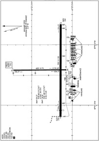
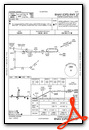
KVPZ Airport Diagram
VFR Chart of KVPZ
Sectional Charts at SkyVector.com
IFR Chart of KVPZ
Enroute Charts at SkyVector.com
Location Information for KVPZ
Coordinates: N41°27.24' / W87°0.42'Located 01 miles SE of Valparaiso, Indiana on 718 acres of land. View all Airports in Indiana.
Surveyed Elevation is 770 feet MSL.
Operations Data
|
|
Airport Communications
| ASOS: | 125.875 Tel. 219-531-1770 |
|---|---|
| SOUTH BEND APPROACH: | 132.05 257.8 |
| SOUTH BEND DEPARTURE: | 132.05 257.8 |
| CLEARANCE DELIVERY: | 120.525 ;CTC APCH CTL |
| UNICOM: | 122.725 |
| CTAF: | 122.725 |
| AWOS-3PT at PPO (14.2 NE): | 119.825 219-326-6916 |
| AWOS-3 at OXI (17.2 SE): | 135.775 574-772-2041 |
| AWOS-3 at MGC (17.3 NE): | 128.450 219-878-1106 |
- APCH/DEP SVC PRVDD BY CHICAGO ARTCC ON FREQS 135.9/314.0 (GOSHEN RCAG) WHEN SOUTH BEND APCH CTL CLSD.
- COMMUNICATIONS PRVDD BY TERRE HAUTE RADIO ON FREQ 122.3 (CROWNPOINT RCO).
Nearby Navigation Aids
|
| ||||||||||||||||||||||||||||||||||||||||||||||||||||||||||||


Runway 09/27
RWY 09/27 NOT AVBL FOR PART 121/PART 380 OPS WITH SKED PAX CARRYING OPS MORE THAN 9 PAX SEATS AND NON-SKED PAX CARRYING OPS MORE THAN 30 PAX SEATS. 90 DAY PPR FOR UNSKED ACR OPS GTR THAN 30 PAX SEATS - CALL AMGR. | ||
| Dimensions: | 7001 x 150 feet / 2134 x 46 meters | |
|---|---|---|
| Surface: | Asphalt / Grooved in Good Condition | |
| Weight Limits: | D-250, ST-375
PCR VALUE: 405/F/C/X/T
| |
| Edge Lighting: | High Intensity | |
| Runway 09 | Runway 27 | |
| Coordinates: | N41°27.14' / W87°1.19' | N41°27.14' / W86°59.66' |
| Elevation: | 770.0 | 769.0 |
| Traffic Pattern: | Left | Left |
| Runway Heading: | 90° True | 270° True |
| Displaced Threshold: | 500 Feet | |
| Declared Distances: | TORA:7000 TODA:7000 ASDA:7000 LDA:6500 | TORA:6500 TODA:6500 ASDA:6500 LDA:6500 |
| Markings: | Non-Precision Instrument in good condition. | Precision Instrument in good condition. |
| Glide Slope Indicator | P4L (3.00° Glide Path Angle) | P4L (3.00° Glide Path Angle) UNUSBL BYD 7 DEG RIGHT OF CNTRLN. |
| Approach Lights: | MALSR 1,400 Foot Medium-intensity Approach Lighting System with runway alignment indicator lights. | |
| REIL: | Yes | |
| Obstacles: | 60 ft Trees 1212 ft from runway, 402 ft right of center | +96 FT MKD PLINE 5601 FT FM RWY END PERPENDICULAR TO CNTRLN 56:1 SLOPE. |
Runway 18/36
RWY 18/36 NOT AVBL FOR PART 121/PART 380 OPS WITH SKED PAX CARRYING OPS MORE THAN 9 PAX SEATS AND NON-SKED PAX CARRYING OPS MORE THAN 30 PAX SEATS. 90 DAY PPR FOR UNSKED ACR OPS GTR THAN 30 PAX SEATS - CALL AMGR. | ||
| Dimensions: | 4001 x 75 feet / 1220 x 23 meters | |
|---|---|---|
| Surface: | Asphalt / Grooved in Fair Condition | |
| Weight Limits: | S-30, D-45
PCR VALUE: 140/F/C/X/T
| |
| Edge Lighting: | Medium Intensity | |
| Runway 18 | Runway 36 | |
| Coordinates: | N41°27.73' / W87°0.42' | N41°27.07' / W87°0.42' |
| Elevation: | 770.3 | 759.9 |
| Runway Heading: | 180° True | 360° True |
| Declared Distances: | TORA:4001 TODA:4001 ASDA:4001 LDA:4001 | TORA:4001 TODA:4001 ASDA:4001 LDA:4001 |
| Markings: | Non-Precision Instrument in good condition. | Non-Precision Instrument in good condition. |
| Glide Slope Indicator | P2L (3.00° Glide Path Angle) UNUSBL BYD 8 DEG RIGHT OF CNTRLN. | P2L (3.00° Glide Path Angle) UNUSBL BYD 8 DEG RIGHT OF CNTRLN. |
| REIL: | Yes | Yes |
| Obstacles: | 80 ft Trees 2850 ft from runway | 32 ft Trees 966 ft from runway, 180 ft left of center |
Services Available
| Fuel: | 100LL (blue), Jet-A |
|---|---|
| Transient Storage: | Hangars,Tiedowns |
| Airframe Repair: | MAJOR |
| Engine Repair: | MAJOR |
| Bottled Oxygen: | NONE |
| Bulk Oxygen: | NONE |
| Other Services: | CHARTER SERVICE,PILOT INSTRUCTION,AIRCRAFT RENTAL |
Ownership Information
| Ownership: | Publicly owned | |
|---|---|---|
| Owner: | PORTER COUNTY MUNI ARPT AUTH | |
| 4207 MURVIHILL RD | ||
| VALPARAISO, IN 46383 | ||
| 219-462-6508 | ||
| Manager: | KYLE J. KUEBLER | |
| 4207 MURVIHILL RD | ||
| VALPARAISO, IN 46383 | ||
| 219-462-6508 | ||
Other Remarks
- BIRDS & DEER ON & INVOF ARPT.
- FOR CD CTC SOUTH BEND APCH AT 574-251-2609. WHEN SOUTH BEND APCH CLSD, FOR CD CTC CHICAGO ARTCC AT 630-906-8921.
- ACTVT MALSR RWY 27; REIL RWY 9, 18 & 36; PAPI RWY 9, 18, 27 & 36; HIRL RWY 09/27; MIRL RWY 18/36 - CTAF. HIRL RWY 09/27; MIRL RWY 18/36; PRESET TO LOW INTST DUSK - 2300, INCR INTST - CTAF.
Weather Minimums


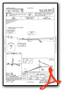
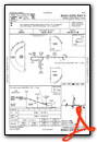
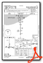
Instrument Approach Procedure (IAP) Charts
Nearby Airports with Instrument Procedures
| ID | Name | Heading / Distance | ||
|---|---|---|---|---|
 |
3HO | Hobart Sky Ranch Airport | 297° | 13.1 |
|
KPPO | La Porte Municipal Airport | 059° | 14.2 |
|
KOXI | Starke County Airport | 115° | 17.2 |
|
KMGC | Michigan City Municipal-Phillips Field Airport | 029° | 17.1 |
|
05C | Griffith-Merrillville Airport | 282° | 18.1 |
|
KGYY | Gary/Chicago International Airport | 298° | 20.8 |
|
KIGQ | Lansing Municipal Airport | 281° | 24.1 |
|
KRWN | Arens Field Airport | 140° | 28.1 |
|
C56 | Bult Field Airport | 261° | 30.7 |
|
KRZL | Jasper County Airport | 194° | 31.4 |
|
C65 | Plymouth Municipal Airport | 099° | 32.4 |
|
KSBN | South Bend International Airport | 063° | 34.6 |
 from SW")


