Login
Register


W43
Hulett Municipal Airport
Official FAA Data Effective 2026-02-19 0901Z
Chart Supplement

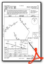
VFR Chart of W43
Sectional Charts at SkyVector.com
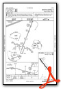
IFR Chart of W43
Enroute Charts at SkyVector.com
Location Information for W43
Coordinates: N44°39.77' / W104°34.07'Located 02 miles SE of Hulett, Wyoming on 330 acres of land. View all Airports in Wyoming.
Surveyed Elevation is 4263 feet MSL.
Operations Data
|
|
Airport Communications
| AWOS-3PT: | 128.775 Tel. 307-467-5575 |
|---|---|
| CTAF: | 122.800 |
| UNICOM: | 122.800 |
| AWOS-3 at SPF (35.1 E): | 118.325 605-642-8536 |
| ASOS at GCC (46.0 SW): | 124.175 307-225-9101 |
| AWOS-3PT at ECS (48.0 S): | 118.0 307-746-4896 |
- APCH/DEP CTL SVC PRVDD BY DENVER ARTCC (ZDV) ON FREQS 127.95/338.2 (RAPID CITY RCAG).
Nearby Navigation Aids
|
| ||||||||||||||||||||||||||||||||||||||||||


Runway 13/31
| Dimensions: | 5500 x 75 feet / 1676 x 23 meters | |
|---|---|---|
| Surface: | Asphalt in Good Condition | |
| Weight Limits: | S-12 | |
| Edge Lighting: | Medium Intensity | |
| Runway 13 | Runway 31 | |
| Coordinates: | N44°40.13' / W104°34.46' | N44°39.41' / W104°33.68' |
| Elevation: | 4194.8 | 4263.7 |
| Traffic Pattern: | Right | |
| Runway Heading: | 142° True | 322° True |
| Markings: | Non-Precision Instrument in fair condition. | Non-Precision Instrument in fair condition. |
| Glide Slope Indicator | P2L (3.00° Glide Path Angle) | P2L (4.00° Glide Path Angle) |
| REIL: | Yes | Yes |
| Obstacles: | 165 ft Hill 3900 ft from runway, 425 ft right of center | |
Services Available
| Fuel: | 100LL (blue), Jet-A |
|---|---|
| Transient Storage: | Tiedowns PILOT SUPPLIED ROPES RQRD FOR TIE DOWNS. |
| Airframe Repair: | NONE |
| Engine Repair: | NONE |
| Bottled Oxygen: | NONE |
| Bulk Oxygen: | NONE |
Ownership Information
| Ownership: | Publicly owned | |
|---|---|---|
| Owner: | TOWN OF HULETT | |
| P.O. BOX 278 | ||
| HULETT, WY 82720 | ||
| 307-467-5771 | ||
| Manager: | TOWN OF HULETT | MELISSA BEARS, TOWN CLERK |
| P.O. BOX 278 | ||
| HULETT, WY 82720 | ||
| 307-467-5771 | ||
Other Remarks
- DEVILS TOWER NATIONAL MONUMENT LOCATED APRXLY 7 MILES SW OF THE ARPT. VOLUNTARY 2 MILE FLIGHT AVOIDANCE RADIUS IN EFFECT JAN-MAY AND JUL-DEC. VOLUNTARY 3 MILE FLIGHT AVOIDANCE RADIUS IN EFFECT IN JUN.
- RETRO-REFLECTIVE MARKERS ALONG TAXIWAYS
- FOR CD CTC DENVER ARTCC AT 303-651-4257.
- 0LL 24 HR SELF SVC CREDIT CARD FUEL AVBL.
- ACTVT REIL RWY 13 & 31; PAPI RWY 13 & 31; MIRL 13/31 - CTAF.
Weather Minimums


Instrument Approach Procedure (IAP) Charts
Departure Procedure (DP) Charts

Nearby Airports with Instrument Procedures
| ID | Name | Heading / Distance | ||
|---|---|---|---|---|
 |
KEFC | Belle Fourche Municipal Airport | 081° | 30.5 |
|
KSPF | Black Hills-Clyde Ice Field Airport | 107° | 35.3 |
|
KGCC | Northeast Wyoming Regional Airport | 246° | 45.8 |
|
KECS | Mondell Field Airport | 166° | 48.0 |
|
49B | Sturgis Municipal Airport | 105° | 53.1 |
|
KRCA | Ellsworth AFB Airport | 115° | 70.2 |
|
KRAP | Rapid City Regional Airport | 119° | 74.8 |
|
KHSR | Hot Springs Municipal Airport | 146° | 93.0 |
|
KBYG | Johnson County Airport | 260° | 94.0 |
|
KBHK | Baker Municipal Airport | 007° | 101.9 |
|
KSHR | Sheridan County Airport | 274° | 103.4 |
|
KBWW | Bowman Regional Airport | 030° | 104.9 |
Airport Images
Do you have a recent image of this airport? Upload it here!


