Login
Register


49B
Sturgis Municipal Airport
Official FAA Data Effective 2026-01-22 0901Z
Chart Supplement

VFR Chart of 49B
Sectional Charts at SkyVector.com
IFR Chart of 49B
Enroute Charts at SkyVector.com
Location Information for 49B
Coordinates: N44°25.12' / W103°22.66'Located 04 miles E of Sturgis, South Dakota on 275 acres of land. View all Airports in South Dakota.
Estimated Elevation is 3254 feet MSL.
Operations Data
|
|
Airport Communications
| AWOS-3P: | 119.275 Tel. 605-347-3356 |
|---|---|
| ELLSWORTH APPROACH: | 119.5 259.1 |
| ELLSWORTH DEPARTURE: | 119.5 289.4 |
| UNICOM: | 122.800 |
| CTAF: | 122.800 |
| AWOS-3 at SPF (18.0 W): | 118.325 605-642-8536 |
| ATIS at RCA (20.2 SE): | 269.9 |
| ASOS at RAP (26.4 SE): | 118.525 605-223-0202 |
- APCH/DEP CTL SVC PRVDD BY DENVER ARTCC (ZDV) ON FREQS 127.95/338.2 (RAPID CITY RCAG) WHEN ELLSWORTH APCH CTL (RCA) CLSD.
Nearby Navigation Aids
|
| ||||||||||||||||||||||||||||||||||||


Runway 11/29
| Dimensions: | 5100 x 75 feet / 1554 x 23 meters | |
|---|---|---|
| Surface: | Concrete in Excellent Condition | |
| Weight Limits: | S-12 | |
| Edge Lighting: | Medium Intensity | |
| Runway 11 | Runway 29 | |
| Coordinates: | N44°25.31' / W103°23.02' | N44°24.86' / W103°22.03' |
| Elevation: | 3244.1 | 3207.8 |
| Runway Heading: | 123° True | 303° True |
| Markings: | Non-Precision Instrument in good condition. | Non-Precision Instrument in good condition. |
| Glide Slope Indicator | P2L (3.00° Glide Path Angle) | P2L (3.00° Glide Path Angle) |
Runway 05/23
| Dimensions: | 3580 x 120 feet / 1091 x 37 meters | |
|---|---|---|
| Surface: | Turf in Good Condition | |
| Runway 05 | Runway 23 | |
| Coordinates: | N44°25.03' / W103°23.22' | N44°25.32' / W103°22.50' |
| Elevation: | 3254.9 | 3225.0 |
| Runway Heading: | 61° True | 241° True |
| Obstacles: | 41 ft Hill 1099 ft from runway | |
Services Available
| Fuel: | 100LL (blue), Jet-A |
|---|---|
| Transient Storage: | Hangars,Tiedowns |
| Airframe Repair: | MAJOR |
| Engine Repair: | MAJOR |
| Bottled Oxygen: | NOT AVAILABLE |
| Bulk Oxygen: | NOT AVAILABLE |
| Other Services: | CROP DUSTING SERVICES,PILOT INSTRUCTION |
Ownership Information
| Ownership: | Publicly owned | |
|---|---|---|
| Owner: | CITY OF STURGIS | |
| 1040 SECOND ST STE. 103 | ||
| STURGIS, SD 57785 | ||
| 605-347-4422 | ||
| Manager: | ROGER BURNHAM | |
| 13345 ALKALI RD | ||
| STURGIS, SD 57785 | ||
| 605-720-9938 | ||
Other Remarks
- WILDLIFE ON AND INVOF ARPT.
- GCO AVBL ON FREQ 121.725 (4 CLICKS TO ELLSWORTH APPROACH AND 6 CLICKS TO DENVER CENTER)
- FOR CD IF UNA VIA GCO CTC DENVER ARTCC AT 303-651-4257.
- HIGH VOL OF ACFT OPRNG INVOF OF MT RUSHMORE AND CRAZY HORSE MONUMENTS AT OR BLW 7500 FT; PILOTS ARE ADVISED TO MNT 122.85 FOR TFC ADVISORIES.
- 0LL FUEL AVBL 24 HRS WITH CREDIT CARD.
- ACTVT MIRL RWY 11/29; PAPI RWY 11 & 29 - CTAF.
- AUTOMATED UNICOM.
Weather Minimums


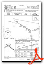
Instrument Approach Procedure (IAP) Charts

Nearby Airports with Instrument Procedures
| ID | Name | Heading / Distance | ||
|---|---|---|---|---|
 |
KSPF | Black Hills-Clyde Ice Field Airport | 282° | 17.9 |
|
KRCA | Ellsworth AFB Airport | 144° | 20.2 |
|
KRAP | Rapid City Regional Airport | 148° | 26.3 |
|
KEFC | Belle Fourche Municipal Airport | 312° | 28.1 |
|
KECS | Mondell Field Airport | 231° | 51.6 |
|
W43 | Hulett Municipal Airport | 286° | 53.1 |
|
KHSR | Hot Springs Municipal Airport | 180° | 63.0 |
|
KPHP | Philip Airport | 105° | 79.9 |
|
KIEN | Pine Ridge Airport | 155° | 92.0 |
|
KGCC | Northeast Wyoming Regional Airport | 268° | 93.1 |
|
KCDR | Chadron Municipal Airport | 172° | 95.6 |
|
84D | Cheyenne Eagle Butte Airport | 068° | 97.1 |
Airport Images
Do you have a recent image of this airport? Upload it here!


