Login
Register


WN07
Decatur Shores Airport
Official FAA Data Effective 2026-02-19 0901Z
VFR Chart of WN07
Sectional Charts at SkyVector.com
IFR Chart of WN07
Enroute Charts at SkyVector.com
Location Information for WN07
Coordinates: N48°29.99' / W122°48.83'Located 08 miles NE of Anacortes, Washington. View all Airports in Washington.
Estimated Elevation is 38 feet MSL.
Operations Data
|
|
Airport Communications
| AWOS-3P at S31 (5.0 W): | 118.525 360-376-2071 |
|---|---|
| ASOS at FHR (8.5 W): | 135.675 360-378-8491 |
| ATIS at NUW (10.9 SE): | 134.15 |
Nearby Navigation Aids
|
| ||||||||||||||||||||||||||||||||||||||||||||||||||||||||||||


Runway 15/33
| Dimensions: | 2550 x 75 feet / 777 x 23 meters | |
|---|---|---|
| Surface: | Gravel-Turf | |
| Edge Lighting: | Low Intensity | |
| Runway 15 | Runway 33 | |
| Traffic Pattern: | Left | Right |
| Obstacles: | ft Hill ft from runway | ft Building ft from runway |
Services Available
| Fuel: | NONE |
|---|---|
| Transient Storage: | NONE |
| Airframe Repair: | NONE |
| Engine Repair: | NONE |
| Bottled Oxygen: | NOT AVAILABLE |
| Bulk Oxygen: | NOT AVAILABLE |
Ownership Information
| Ownership: | Privately Owned | |
|---|---|---|
| Owner: | DECATUR SHORES COMMUNITY ASSOC. | |
| DECATUR ISLAND | ||
| ANACORTES, WA 98221 | ||
| 360-375-6044 | ||
| Manager: | DSCA AIRFIELD CHAIR | PRESIDENT. |
| DECATUR ISLAND | ||
| ANACORTES, WA 98221 | ||
| 360-375-6044 | ||
Other Remarks
- LAND TO THE NORTH; TKOF TO THE SOUTH.
- FOR CD CTC WHIDBEY APCH AT 360-257-3310.
- DUSK-2200
Nearby Airports with Instrument Procedures
| ID | Name | Heading / Distance | ||
|---|---|---|---|---|
 |
KFHR | Friday Harbor Airport | 279° | 8.5 |
|
KNUW | Whidbey Island NAS (Ault Field) Airport | 144° | 10.9 |
|
KORS | Orcas Island Airport | 342° | 13.1 |
|
KBVS | Skagit Regional Airport | 096° | 15.7 |
|
KOKH | Delaurentis Airport | 159° | 15.9 |
|
KBLI | Bellingham International Airport | 031° | 20.7 |
|
CYYJ | Victoria International Airport | 290° | 25.9 |
|
0S9 | Jefferson County International Airport | 179° | 26.8 |
|
KNOW | Port Angeles CGAS Airport | 228° | 32.3 |
|
KAWO | Arlington Municipal Airport | 127° | 33.2 |
|
KCLM | William R Fairchild International Airport | 230° | 35.7 |
|
CYXX | Abbotsford Airport | 029° | 36.3 |
Airport Images

By: dnp@bjllc.net
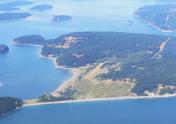
By: Dave


