Login
Register
Z40
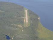
Goose Bay Airport
Official FAA Data Effective 2025-11-27 0901Z
VFR Chart of Z40
Sectional Charts at SkyVector.com
IFR Chart of Z40
Enroute Charts at SkyVector.com
Location Information for Z40
Coordinates: N61°23.68' / W149°50.54'Located 00 miles E of Goose Bay, Alaska. View all Airports in Alaska.
Estimated Elevation is 78 feet MSL.
Operations Data
|
|
Airport Communications
| CTAF: | 122.900 |
|---|---|
| ATIS at EDF (8.7 S): | 273.5 |
| ATIS at FRN (9.5 SE): | 134.25 |
| ASOS at FRN (9.5 SE): | 134.25 |
Nearby Navigation Aids
|
| ||||||||||||||||||||||||||||||||||||
Runway 08/26
| Dimensions: | 3000 x 75 feet / 914 x 23 meters | |
|---|---|---|
| Surface: | Gravel in Fair Condition | |
| Runway 08 | Runway 26 | |
| Coordinates: | N61°23.69' / W149°51.05' | N61°23.66' / W149°50.02' |
| Elevation: | 78.0 | 78.0 |
| Traffic Pattern: | Right | Left |
| Markings: | Non-Standard | Non-Standard |
| Obstacles: | 15 ft Road 0 ft from runway, 80 ft left of center | 15 ft Road 0 ft from runway, 80 ft right of center |
Ownership Information
| Ownership: | Publicly owned | |
|---|---|---|
| Owner: | ALASKA DOT&PF CENTRAL REGION | |
| PO BOX 196900 | ||
| ANCHORAGE, AK 99519-6900 | ||
| 907-269-0782 | ||
| Manager: | KYLER HYLTON | |
| 289 INNER SPRINGER LOOP RD. | ||
| PALMER, AK 99645 | ||
| 907-246-3325 | ||
Other Remarks
- RWY COND UNMNTD; RCMD VISUAL INSP BFR USE.
- 808 FT LGTD TWR 11700 FT NNW OF RWY.
- WX CAMERA AVBL ON INTERNET AT HTTPS://WEATHERCAMS.FAA.GOV
- LRG MIL LOW ALT OPS INVOF R-2203, GOOSE BAY, BIRCHWOOD & BIG LAKE ARPTS. MIL ACFT MNT MULT CTAF FREQ. SEE CURRENT ANCHORAGE VFR TAC INSERT & CNTR NOTAMS.
- RWY END THR PANEL.
- RWY END THR PANEL.
Nearby Airports with Instrument Procedures
| ID | Name | Heading / Distance | ||
|---|---|---|---|---|
 |
PAGQ | Big Lake Airport | 005° | 8.5 |
 |
PAED | Elmendorf AFB Airport | 173° | 8.7 |
 |
PAMR | Merrill Field Airport | 180° | 10.9 |
 |
PAWS | Wasilla Airport | 039° | 13.8 |
 |
PANC | Ted Stevens Anchorage International Airport | 198° | 14.0 |
 |
PAUO | Willow Airport | 344° | 22.5 |
 |
PAAQ | Warren "Bud" Woods Palmer Municipal Airport | 060° | 24.8 |
 |
PATK | Talkeetna Airport | 352° | 56.2 |
 |
PAEN | Kenai Municipal Airport | 220° | 64.2 |
 |
PASX | Soldotna Airport | 212° | 65.5 |
 |
PAWD | Seward Airport | 170° | 77.1 |
 |
PAHO | Homer Airport | 205° | 115.8 |


