Login
Register


VKS
Vicksburg Municipal Airport
Official FAA Data Effective 2025-11-27 0901Z
Chart Supplement

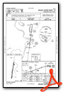
VFR Chart of KVKS
Sectional Charts at SkyVector.com
IFR Chart of KVKS
Enroute Charts at SkyVector.com
Location Information for KVKS
Coordinates: N32°14.35' / W90°55.69'Located 07 miles SW of Vicksburg, Mississippi on 316 acres of land. View all Airports in Mississippi.
Surveyed Elevation is 107 feet MSL.
Operations Data
|
|
Airport Communications
| AWOS-3: | 118.85 Tel. 601-801-5376 |
|---|---|
| CTAF: | 122.800 |
| UNICOM: | 122.800 |
| ASOS at TVR (8.4 NW): | 118.525 318-574-4866 |
| AWOS-3PT at JVW (26.6 E): | 118.675 601-857-3887 |
| ASOS at HKS (36.3 E): | 120.625 601-354-4037 |
- APCH/DEP SVC PRVDD BY MEMPHIS ARTCC ON FREQS 132.5/259.1 (GREENWOOD & JACKSON RCAGS).
Nearby Navigation Aids
|
| ||||||||||||||||||||||||||||||||||||||||||||||||||||||||||||


Runway 01/19
| Dimensions: | 5000 x 100 feet / 1524 x 30 meters | |
|---|---|---|
| Surface: | Asphalt in Fair Condition | |
| Weight Limits: | S-30, D-50, ST-90 | |
| Edge Lighting: | Medium Intensity | |
| Runway 01 | Runway 19 | |
| Coordinates: | N32°13.94' / W90°55.76' | N32°14.76' / W90°55.63' |
| Elevation: | 100.4 | 106.6 |
| Traffic Pattern: | Left | Left |
| Runway Heading: | 8° True | 188° True |
| Displaced Threshold: | 299 Feet | 471 Feet |
| Markings: | Non-Precision Instrument in good condition. | Non-Precision Instrument in good condition. |
| Glide Slope Indicator | P2R (3.00° Glide Path Angle) | P2L (3.00° Glide Path Angle) |
| Obstacles: | 105 ft Trees 2500 ft from runway APCH RATIO 28:1 TO DTHR. |
38 ft Tree 1100 ft from runway, 200 ft left of center APCH RATIO 41:1 TO DTHR. |
Services Available
| Fuel: | 100LL (blue), Jet A+, Jet A-1+, J |
|---|---|
| Transient Storage: | Hangars,Tiedowns HNGR FEE RQRD. |
| Airframe Repair: | NONE AVBL 601-529-2909. |
| Engine Repair: | NONE AVBL 601-529-2909. |
| Bottled Oxygen: | NONE |
| Bulk Oxygen: | NONE |
| Other Services: | PILOT INSTRUCTION,AIRCRAFT RENTAL |
Ownership Information
| Ownership: | Publicly owned | |
|---|---|---|
| Owner: | CITY OF VICKSBURG | |
| PO BOX 150 | ||
| VICKSBURG, MS 39180 | ||
| 601-634-4525 | ||
| Manager: | RON DAVIS | |
| 5855 HIGHWAY 61 SOUTH | ||
| VICKSBURG, MS 39180 | ||
| 601-218-5789 | ||
Other Remarks
- N PARL TWY CLSD.
- TERM STUB TWY ONLY.
- FOR CD CTC MEMPHIS ARTCC AT 901-368-8453/8449.
- 0LL FUEL 24 HRS WITH CREDIT CARD.
- ACTVT PAPI RWY 19; MIRL RWY 01/19 - CTAF. PAPI RWY 01 OPR CONSLY.
Weather Minimums


Instrument Approach Procedure (IAP) Charts

Nearby Airports with Instrument Procedures
| ID | Name | Heading / Distance | ||
|---|---|---|---|---|
 |
KTVR | Vicksburg Tallulah Regional Airport | 323° | 8.4 |
|
KJVW | John Bell Williams Airport | 081° | 26.6 |
|
M11 | Copiah County Airport | 125° | 35.0 |
|
KHKS | Hawkins Field Airport | 080° | 36.3 |
|
KHEZ | Hardy-Anders Field/Natchez-Adams County Airport | 206° | 41.9 |
|
KJAN | Jackson-Medgar Wiley Evers International Airport | 084° | 43.6 |
|
KMBO | Bruce Campbell Field Airport | 073° | 43.6 |
|
M79 | John H Hooks Jr Memorial Airport | 289° | 45.3 |
|
87I | Yazoo County Airport | 031° | 45.2 |
|
1R7 | Brookhaven-Lincoln County Airport | 144° | 46.3 |
|
0R4 | Concordia Parish Airport | 216° | 50.2 |
|
KBQP | Morehouse Memorial Airport | 302° | 57.4 |
Airport Images
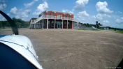
By: jtrolinger


Comments
VKS
Friendly, open, welcoming and a great fuel stop. The terminal, inside and out, is worth stopping by for a photo op.