Login
Register


FDK
Frederick Municipal Airport
Official FAA Data Effective 2025-12-25 0901Z
Chart Supplement

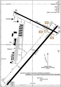
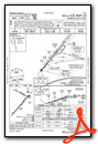
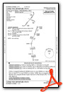
KFDK Airport Diagram
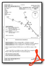
VFR Chart of KFDK
Sectional Charts at SkyVector.com
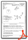
IFR Chart of KFDK
Enroute Charts at SkyVector.com
Location Information for KFDK
Coordinates: N39°25.02' / W77°22.48'Located 00 miles E of Frederick, Maryland on 616 acres of land. View all Airports in Maryland.
Surveyed Elevation is 308 feet MSL.
TPA - 600 AGL HEL, 1100 AGL SNGL AND LGT TWINS, 1600 AGL LRG TWINS AND JETS.
Operations Data
|
|
Airport Communications
| ATIS: | 124.875 |
|---|---|
| AWOS-3: | Tel. 301-600-1457 |
| FREDERICK TOWER: | 132.4 |
| FREDERICK GROUND: | 127.425 |
| POTOMAC APPROACH: | 126.1 338.25 |
| POTOMAC DEPARTURE: | 126.1 338.25 |
| CLEARANCE DELIVERY: | 127.425 126.9 ;WHEN TWR CLSD |
| CTAF: | 132.400 |
| UNICOM: | 122.950 |
| CONLE DP: | 126.1 338.25 |
| TRSTN STAR: | 126.75 307.2 |
| TERPZ DP: | 126.1 338.25 |
| AWOS-3PT at GAI (17.8 SE): | 128.275 301-977-2971 |
| AWOS-3 at DMW (20.5 NE): | 121.25 410-876-1281 |
| AWOS-3 at JYO (22.1 SW): | 125.225 703-777-3781 |
- POTOMAC CD 126.9 OR 866-709-4993 (WHEN TWR CLSD).
Nearby Navigation Aids
|
| ||||||||||||||||||||||||||||||||||||||||||||||||||||||||||||


Runway 05/23
| Dimensions: | 5819 x 100 feet / 1774 x 30 meters | |
|---|---|---|
| Surface: | Asphalt / Grooved in Good Condition | |
| Weight Limits: | 30 /F/C/X/T, S-60 | |
| Edge Lighting: | High Intensity | |
| Runway 05 | Runway 23 | |
| Coordinates: | N39°24.50' / W77°22.91' | N39°25.23' / W77°22.11' |
| Elevation: | 308.9 | 282.6 |
| Traffic Pattern: | Right | Left |
| Runway Heading: | 40° True | 220° True |
| Markings: | Non-Precision Instrument in good condition. | Precision Instrument in fair condition. |
| Glide Slope Indicator | P4L (3.00° Glide Path Angle) | P4L (3.00° Glide Path Angle) |
| Approach Lights: | ODALS Omnidirectional Approach Lighting System | |
| REIL: | Yes | Yes |
| Obstacles: | 43 ft Trees 1383 ft from runway, 219 ft left of center | 111 ft Trees 2894 ft from runway, 721 ft left of center |
Runway 12/30
| Dimensions: | 3599 x 75 feet / 1097 x 23 meters | |
|---|---|---|
| Surface: | Asphalt in Good Condition | |
| Edge Lighting: | Medium Intensity | |
| Runway 12 | Runway 30 | |
| Coordinates: | N39°25.40' / W77°22.79' | N39°25.14' / W77°22.10' |
| Elevation: | 294.2 | 284.0 |
| Traffic Pattern: | Right | |
| Runway Heading: | 116° True | 296° True |
| Markings: | Non-Precision Instrument in fair condition. | Non-Precision Instrument in fair condition. |
| Glide Slope Indicator | P2L (3.00° Glide Path Angle) | P2L (4.00° Glide Path Angle) |
| REIL: | Yes | Yes |
Services Available
| Fuel: | 100LL (blue), Jet-A |
|---|---|
| Transient Storage: | Hangars,Tiedowns |
| Airframe Repair: | MAJOR |
| Engine Repair: | MAJOR |
| Bottled Oxygen: | HIGH/LOW |
| Bulk Oxygen: | NONE |
| Other Services: | AVIONICS,CHARTER SERVICE,PILOT INSTRUCTION,AIRCRAFT RENTAL,AIRCRAFT SALES |
Ownership Information
| Ownership: | Publicly owned | |
|---|---|---|
| Owner: | CITY OF FREDERICK | |
| 101 N COURT ST | ||
| FREDERICK, MD 21701 | ||
| 301-600-1380 | ||
| Manager: | ANDREW MOORE | |
| 111 AIRPORT DRIVE EAST | ||
| FREDERICK, MD 21701 | ||
| 301-600-2201 | EMERG 301-600-1440 | |
Other Remarks
- FOR CD WHEN TWR CLSD CTC POTOMAC APCH 126.9 OR 866-709-4993.
- -15 FT DEPRESSION 400 FT LONG; 246 FT L OF CNTRLN; PARALLEL TO APCH END.
- 0LL SELF SERVE 100LL AVBL H24 WITH CREDIT CARD.
- ACTVT ODALS RWY 23; REIL RWY 12, 23 & 30; PAPI RWY 23; HIRL RWY 05/23; MIRL RWY 12/30 - CTAF.
- TPA - 600 AGL HEL, 1100 AGL SNGL AND LGT TWINS, 1600 AGL LRG TWINS AND JETS.
Weather Minimums

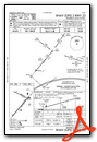
Standard Terminal Arrival (STAR) Charts
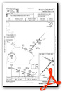
Instrument Approach Procedure (IAP) Charts
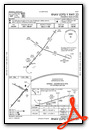
Departure Procedure (DP) Charts
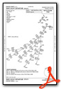
Nearby Airports with Instrument Procedures
| ID | Name | Heading / Distance | ||
|---|---|---|---|---|
 |
W50 | Davis Airport | 134° | 14.7 |
|
2W2 | Clearview Airpark Airport | 079° | 16.9 |
|
KGAI | Montgomery County Airpark Airport | 146° | 17.8 |
|
KDMW | Carroll County Regional/Jack B Poage Field Airport | 055° | 20.5 |
|
KJYO | Leesburg Exec Airport | 202° | 22.0 |
|
KHGR | Hagerstown Regional/Richard A Henson Field Airport | 317° | 23.9 |
|
W05 | Gettysburg Regional Airport | 010° | 25.9 |
|
KMRB | Eastern Wv Regional/Shepherd Field Airport | 268° | 28.3 |
|
KIAD | Washington Dulles International Airport | 188° | 28.4 |
|
KCGS | College Park Airport | 140° | 33.6 |
|
KFME | Tipton Airport | 124° | 34.9 |
|
N68 | Franklin County Regional Airport | 339° | 35.6 |

")


Comments
KFDK now Class D
~~In a sky full of people, only some what to fly, isn't that crazy? --Seal
KFDK self fuel price is $5.00 instead $4.70 as published.
Self fueled 09/21/2017
Price Guaranteed by FBO, by Signature.... $4.70
But in reality self fuel price is $5.00
A20
Pages