Login
Register
B18
Alton Bay Seaplane Base
Official FAA Data Effective 2024-11-28 0901Z
VFR Chart of B18
Sectional Charts at SkyVector.com
IFR Chart of B18
Enroute Charts at SkyVector.com
Location Information for B18
Coordinates: N43°28.65' / W71°14.22'Located 02 miles N of Alton Bay, New Hampshire. View all Airports in New Hampshire.
Estimated Elevation is 504 feet MSL.
Operations Data
|
|
Airport Communications
| UNICOM: | 122.800 |
|---|---|
| CTAF: | 122.800 |
| AWOS-3PT at LCI (9.7 NW): | 133.525 603-524-5134 |
| ASOS at DAW (17.8 SE): | 135.275 603-332-7814 |
| ASOS at CON (20.1 SW): | 132.325 603-224-6558 |
Nearby Navigation Aids
|
| ||||||||||||||||||||||||||||||||||||||||||||||||||||||||||||
Runway 01W/19W
RWY 01W THLD APRXLY 100 FT NE OF FLOATING BANDSTAND. | ||
| Dimensions: | 2600 x 100 feet / 792 x 30 meters | |
|---|---|---|
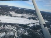
| Surface: | Water in Excellent Condition RWY 01W/19W HAS ICE IN WINTER PLOWED TO APRXLY 2730 FT. CK NOTAMS FOR ICE RWY CONDS. | |
| Runway 01W | Runway 19W | |
| Obstacles: | 12 ft Building 161 ft from runway, 109 ft left of center | |
Ownership Information
| Ownership: | Publicly owned | |
|---|---|---|
| Owner: | STATE OF NEW HAMPSHIRE | PUBLIC WATERS OF THE STATE OF NH. |
| NHDOT, AERONAUTICS, 7 HAZEN DR | ||
| CONCORD, NH 03302 | ||
| 603-271-2552 | ||
| Manager: | JASON LEAVITT | |
| 7 HAZEN DR, PO BOX 483 | ||
| CONCORD, NH 03302 | ||
| 603-545-2315 | ||
Other Remarks
- RWY 01W/19W PWRLINE MKD WITH ORANGE BALLS 1000 FT S OF THR AT S END; LESS THAN 30 FT HGT ALG ROADWAY.
- ALL SEAPLANE TKOFS & LDGS MUST BE N OF THE BANDSTAND. ALL TVL S OF THE BANDSTAND MUST NOT EXCEED HEADWAY SPD.
- FOR SEAPLANE PRKG & ICE RWY CONDS CALL AMGR 603-545-2315.
- FOR CD CTC BOSTON APCH 603-594-5552.
- TKOF & LDG USING RWY 19W PROHIBITED JAN - MAR.
Nearby Airports with Instrument Procedures
| ID | Name | Heading / Distance | ||
|---|---|---|---|---|
 |
KLCI | Laconia Municipal Airport | 306° | 9.8 |
 |
KDAW | Skyhaven Airport | 130° | 17.8 |
 |
KCON | Concord Municipal Airport | 215° | 20.2 |
 |
KSFM | Sanford Seacoast Regional Airport | 102° | 23.7 |
 |
3B4 | Seacoast Airfield Airport | 134° | 28.5 |
 |
KPSM | Portsmouth International At Pease Airport | 142° | 30.1 |
 |
KIZG | Eastern Slopes Regional Airport | 022° | 33.3 |
 |
B19 | Biddeford Municipal Airport | 091° | 33.4 |
 |
KMHT | Manchester Boston Regional Airport | 195° | 33.8 |
 |
KPWM | Portland International Jetport Airport | 075° | 41.7 |
 |
2B3 | Parlin Field Airport | 262° | 41.9 |
 |
KASH | Boire Field Airport | 196° | 43.4 |


Comments
Ice Runway is closed
I called today Feb 6 and the message is: closed until further notice due to the snow storm.
it may open for the weekend.
Runway Open in good condition February 11
call ahead
Pages