Login
Register


48A
Cochran Airport
Official FAA Data Effective 2024-11-28 0901Z
Chart Supplement

VFR Chart of 48A
Sectional Charts at SkyVector.com
IFR Chart of 48A
Enroute Charts at SkyVector.com
Location Information for 48A
Coordinates: N32°24.04' / W83°16.70'Located 04 miles E of Cochran, Georgia on 125 acres of land. View all Airports in Georgia.
Surveyed Elevation is 377 feet MSL.
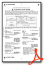
Operations Data
|
|
Airport Communications
| AWOS-3PT: | 120.975 Tel. 478-271-5897 |
|---|---|
| ATLANTA APPROACH: | 124.2 279.6 388.2 ;7000 FT & ABV |
| ATLANTA DEPARTURE: | 124.2 279.6 388.2 ;7000 FT & ABV |
| UNICOM: | 122.800 |
| CTAF: | 122.800 |
| ATIS at EZM (13.4 SE): | 119.425 |
| AWOS-3 at EZM (13.5 SE): | 119.425 478-374-9979 |
| AWOS-3 at DBN (17.8 NE): | 118.425 478-277-9051 |
- ATLANTA LARGE TRACON PROVIDES APCH/DEP SVC 0615-2300 ON FREQ 124.2/279.6; ATLANTA ARTCC PROVIDES APCH/DEP SVC 2300-0615 ON FREQS 134.5/360.75 (MACON RCAG).
Nearby Navigation Aids
|
| ||||||||||||||||||||||||||||||||||||||||||||||||||||||||||||


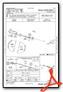
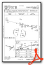
Runway 11/29
| Dimensions: | 4400 x 75 feet / 1341 x 23 meters | |
|---|---|---|
| Surface: | Asphalt in Good Condition | |
| Edge Lighting: | Medium Intensity | |
| Runway 11 | Runway 29 | |
| Coordinates: | N32°24.18' / W83°17.23' | N32°24.01' / W83°16.40' |
| Elevation: | 377.4 | 333.6 |
| Runway Heading: | 104° True | 284° True |
| Markings: | Non-Precision Instrument in good condition. | Non-Precision Instrument in good condition. |
| Glide Slope Indicator | P2L (3.25° Glide Path Angle) | P2L (3.00° Glide Path Angle) |
| Obstacles: | 67 ft Trees 1359 ft from runway, 405 ft left of center | 68 ft Trees 2363 ft from runway, 415 ft left of center |
Runway 05/23
RWY 5/23 IS DAYLIGHT USE ONLY. | ||
| Dimensions: | 3202 x 50 feet / 976 x 15 meters | |
|---|---|---|
| Surface: | Asphalt in Poor Condition RWY 05/23 PAVEMENT IN POOR COND. | |
| Weight Limits: | S-25 | |
| Runway 05 | Runway 23 | |
| Coordinates: | N32°23.78' / W83°16.78' | N32°24.14' / W83°16.33' |
| Elevation: | 324.2 | 332.5 |
| Traffic Pattern: | Left | Left |
| Runway Heading: | 46° True | 226° True |
| Displaced Threshold: | 140 Feet | |
| Declared Distances: | TORA:3202 TODA:3202 ASDA:3202 LDA:3062 | |
| Markings: | Non-Precision Instrument in good condition. | Non-Precision Instrument in good condition. |
| Obstacles: | 44 ft Trees 720 ft from runway, 88 ft right of center | 40 ft Trees 1143 ft from runway, 27 ft left of center |
Services Available
| Fuel: | 100LL (blue) |
|---|---|
| Transient Storage: | Tiedowns |
| Airframe Repair: | MINOR |
| Engine Repair: | MINOR |
| Bottled Oxygen: | NONE |
| Bulk Oxygen: | NONE |
| Other Services: | CROP DUSTING SERVICES |
Ownership Information
| Ownership: | Publicly owned | |
|---|---|---|
| Owner: | CITY OF COCHRAN | |
| CITY HALL, PO BOX 8 | ||
| COCHRAN, GA 31014 | ||
| 478-934-6346 | ||
| Manager: | JIM WASHBURN | |
| 829 GA HWY 126 | ||
| COCHRAN, GA 31014 | ||
| 478-291-6582 | ALT PHONE 478-230-7843 | |
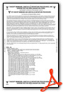
Other Remarks
- NON STD TURNAROUNDS, INADEQUATE SEPARATION RUNWAY 05/23.
- FOR CD CTC ATLANTA APCH AT 678-364-6132, WHEN APCH CLSD CTC ATLANTA ARTCC AT 770-210-7692.
- 0LL 24HR FUEL SELF SERV W/MAJOR CREDIT CARD.
- MIRL RWY 11/29 PRESET LOW DAWN-0800, DUSK-2100; TO ACTVT OR INCRS INTST - CTAF.
Weather Minimums
Instrument Approach Procedure (IAP) Charts
Nearby Airports with Instrument Procedures
| ID | Name | Heading / Distance | ||
|---|---|---|---|---|
 |
KEZM | Heart of Georgia Regional Airport | 145° | 13.4 |
|
KDBN | W H 'Bud' Barron Airport | 056° | 17.8 |
|
KWRB | Robins AFB Airport | 312° | 21.4 |
|
KPXE | Perry-Houston County Airport | 284° | 25.7 |
|
KMCN | Middle Georgia Regional Airport | 313° | 25.7 |
|
KMQW | Telfair-Wheeler Airport | 131° | 27.3 |
|
KMAC | Macon Downtown Airport | 330° | 29.0 |
|
KCKF | Crisp County-Cordele Airport | 225° | 35.3 |
|
53A | Dr C P Savage Sr Airport | 261° | 37.5 |
|
KOKZ | Kaolin Field Airport | 033° | 40.6 |
|
KFZG | Fitzgerald Municipal Airport | 179° | 42.9 |
|
KAZE | Hazlehurst Airport | 133° | 44.5 |
Airport Images
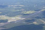
By: afets93


Comments
Courtesy Car
A fairly nice Courtesy Car is also available.
Off Hours Contact
Jim Washburn @ 478 230-0860