Login
Register
VCB
Nut Tree Airport
Official FAA Data Effective 2024-11-28 0901Z
VFR Chart of KVCB
Sectional Charts at SkyVector.com
IFR Chart of KVCB
Enroute Charts at SkyVector.com
Location Information for KVCB
Coordinates: N38°22.69' / W121°57.67'Located 02 miles NE of Vacaville, California on 262 acres of land. View all Airports in California.
Surveyed Elevation is 116 feet MSL.
Operations Data
|
|
Airport Communications
| ASOS: | 134.75 Tel. 707-448-1594 |
|---|---|
| TRAVIS APPROACH: | 128.4 281.45 |
| TRAVIS DEPARTURE: | 128.4 281.45 |
| CTAF: | 122.850 |
| D-ATIS at SUU (7.0 S): | 135.55 |
| AWOS-3 at EDU (12.2 NE): | 119.025 530-754-6839 |
| AWOS-3P at DWA (13.1 NE): | 125.775 530-750-2759 |
Nearby Navigation Aids
|
| ||||||||||||||||||||||||||||||||||||
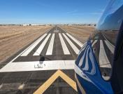
Runway 02/20
| Dimensions: | 4700 x 75 feet / 1433 x 23 meters | |
|---|---|---|
| Surface: | Asphalt in Good Condition | |
| Weight Limits: | S-30 | |
| Edge Lighting: | Medium Intensity | |
| Runway 02 | Runway 20 | |
| Coordinates: | N38°22.37' / W121°57.95' | N38°23.02' / W121°57.40' |
| Elevation: | 115.8 | 111.7 |
| Traffic Pattern: | Left | Right |
| Runway Heading: | 34° True | 214° True |
| Markings: | Non-Precision Instrument in good condition. | Non-Precision Instrument in good condition. |
| Glide Slope Indicator | P2L (3.75° Glide Path Angle) | P2L (3.75° Glide Path Angle) |
| REIL: | Yes | Yes |
| Obstacles: | 52 ft Tree 1450 ft from runway, 200 ft right of center | |
Services Available
| Fuel: | 100LL (blue), Jet-A |
|---|---|
| Transient Storage: | Tiedowns |
| Airframe Repair: | MAJOR |
| Engine Repair: | MAJOR |
| Bottled Oxygen: | NONE |
| Bulk Oxygen: | NONE |
| Other Services: | CHARTER SERVICE,PILOT INSTRUCTION,AIRCRAFT RENTAL,AIRCRAFT SALES |
Ownership Information
| Ownership: | Publicly owned | |
|---|---|---|
| Owner: | COUNTY OF SOLANO | |
| 675 TEXAS ST | ||
| FAIRFIELD, CA 94533 | ||
| 707-784-6100 | ||
| Manager: | CATHERINE MCKENZIE COOK | |
| 301 COUNTY AIRPORT ROAD, SUITE 205 | ||
| VACAVILLE, CA 95688 | ||
| 707-469-4603 | ||
Other Remarks
- NO TURNS TO XW BLW 800 FT MSL; RMN W OF INSTA HWY FOR RWY 20, NOISE SENSITIVE AREA W OF ARPT.
- TWY LGTS ON PARL TWY ONLY.
- RWY 02 CALM WIND RWY.
- FOR CD CTC OAKLAND ARTCC AT 510-745-3380.
- AFT 2200 ACTVT MIRL & PARALLEL TWY LGTS RY 02/20; PAPI & REIL RYS 02 & 20 - CTAF.
Weather Minimums
Instrument Approach Procedure (IAP) Charts
Departure Procedure (DP) Charts
Nearby Airports with Instrument Procedures
| ID | Name | Heading / Distance | ||
|---|---|---|---|---|
 |
KSUU | Travis AFB Airport | 165° | 7.0 |
 |
KEDU | University Airport | 041° | 12.3 |
 |
KDWA | Yolo County Airport | 022° | 13.0 |
 |
O88 | Rio Vista Municipal Airport | 132° | 16.5 |
 |
KAPC | Napa County Airport | 236° | 18.0 |
 |
O41 | Watts-Woodland Airport | 013° | 18.2 |
 |
KSAC | Sacramento Exec Airport | 069° | 23.5 |
 |
KCCR | Buchanan Field Airport | 191° | 23.7 |
 |
KSMF | Sacramento International Airport | 042° | 25.8 |
 |
O69 | Petaluma Municipal Airport | 256° | 31.3 |
 |
KDVO | Gnoss Field Airport | 243° | 31.5 |
 |
KMCC | Mc Clellan Airfield Airport | 056° | 31.6 |


