Login
Register
BAM
Battle Mountain Airport
Official FAA Data Effective 2024-11-28 0901Z
VFR Chart of KBAM
Sectional Charts at SkyVector.com
IFR Chart of KBAM
Enroute Charts at SkyVector.com
Location Information for KBAM
Coordinates: N40°35.94' / W116°52.46'Located 03 miles SE of Battle Mountain, Nevada on 1066 acres of land. View all Airports in Nevada.
Surveyed Elevation is 4536 feet MSL.
Operations Data
|
|
Airport Communications
| AWOS-3: | 119.45 Tel. 775-635-8419 |
|---|---|
| CTAF: | 122.800 |
| UNICOM: | 122.800 |
| ASOS at WMC (46.0 NW): | 120.175 775-625-2200 |
| ASOS at EKO (51.3 E): | 119.275 775-778-9639 |
| AWOS-3 at 05U (71.9 SE): | 128.325 775-237-6133 |
- APCH/DEP CTL SVC PRVDD BY SALT LAKE ARTCC (ZLC) ON FREQS 132.25/338.35 (BATTLE MOUNTAIN RCAG).
- COMMUNICATIONS PRVDD BY RENO RADIO ON FREQ 122.4 (BATTLE MOUNTAIN RCO).
Nearby Navigation Aids
|
| ||||||||||||||||||||||||||||||||||||
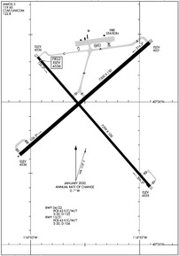
Runway 04/22
| Dimensions: | 7300 x 150 feet / 2225 x 46 meters | |
|---|---|---|
| Surface: | Asphalt in Good Condition | |
| Weight Limits: | S-30, D-125
PCR VALUE: 63/F/C/W/T
| |
| Edge Lighting: | Medium Intensity | |
| Runway 04 | Runway 22 | |
| Coordinates: | N40°35.63' / W116°53.10' | N40°36.42' / W116°51.91' |
| Elevation: | 4535.6 | 4531.3 |
| Traffic Pattern: | Left | Left |
| Runway Heading: | 49° True | 229° True |
| Markings: | Non-Precision Instrument in fair condition. | Non-Precision Instrument in fair condition. |
| Glide Slope Indicator | V2R (3.00° Glide Path Angle) | P4L (3.00° Glide Path Angle) |
Runway 13/31
| Dimensions: | 7299 x 100 feet / 2225 x 30 meters | |
|---|---|---|
| Surface: | Asphalt in Poor Condition PCI 54 L & T ALLIGATOR PATCHING, BONE CRACKING, WEEDS GROWING THRU CRACKS. | |
| Weight Limits: | S-30, D-104
PCR VALUE: 63/F/C/W/T
| |
| Edge Lighting: | Medium Intensity | |
| Runway 13 | Runway 31 | |
| Coordinates: | N40°36.32' / W116°52.93' | N40°35.41' / W116°51.90' |
| Elevation: | 4535.9 | 4535.4 |
| Traffic Pattern: | Left | Left |
| Runway Heading: | 139° True | 319° True |
| Markings: | Basic in poor condition. | Basic in poor condition. |
Helipad H1
| Dimensions: | 60 x 60 feet / 18 x 18 meters | |
|---|---|---|
| Surface: | Concrete in Good Condition | |
| Edge Lighting: | Perimeter | |
| Coordinates: | N40°36.40' / W116°52.37' | N0°0.00' / E0°0.00' |
| Elevation: | 4528.0 | |
| Markings: | Basic in poor condition. | |
Helipad H2
| Dimensions: | 60 x 60 feet / 18 x 18 meters | |
|---|---|---|
| Surface: | Concrete in Good Condition | |
| Edge Lighting: | Perimeter | |
| Coordinates: | N40°36.40' / W116°52.40' | N0°0.00' / E0°0.00' |
| Elevation: | 4528.0 | |
| Markings: | Basic in poor condition. | |
Services Available
| Fuel: | 100LL (blue), Jet-A |
|---|---|
| Transient Storage: | Hangars,Tiedowns |
| Airframe Repair: | MAJOR |
| Engine Repair: | MAJOR |
| Bottled Oxygen: | NONE |
| Bulk Oxygen: | NONE |
| Other Services: | AIR FREIGHT SERVICES,CROP DUSTING SERVICES,AIR AMBULANCE SERVICES,ANNUAL SURVEYING |
Ownership Information
| Ownership: | Publicly owned | |
|---|---|---|
| Owner: | LANDER COUNTY | |
| 50 STATE ROUTE 305 | ||
| BATTLE MOUNTAIN, NV 89820 | ||
| 775-635-2885 | ||
| Manager: | BERT RAMOS | |
| 50 STATE ROUTE 305 | ||
| BATTLE MOUNTAIN, NV 89820 | ||
| 775-455-6860 | ||
Other Remarks
- (E81) EDGE REFLECTORS ON TWYS AND RAMP.
- FOR CD IF UNA TO CTC ON FSS FREQ, CTC SALT LAKE ARTCC AT 801-320-2568.
- RWY NRS FADED.
- THR MARKINGS FADED.
- RWY NRS FADED.
- THR MARKINGS FADED.
- BLACK OUTLINE IS PARTIALLY VSB, W INTERIOR GONE.
- BLACK OUTLINE PARTIALLY VSB. W INTERIOR GONE.
- ACTVT PAPI RWY 22; MIRL RWYS 04/22 & 13/31; PERI LGTS H1 - CTAF.
Weather Minimums
Instrument Approach Procedure (IAP) Charts
Nearby Airports with Instrument Procedures
| ID | Name | Heading / Distance | ||
|---|---|---|---|---|
 |
KWMC | Winnemucca Municipal Airport | 293° | 46.1 |
 |
KEKO | Elko Regional Airport | 074° | 51.2 |
 |
05U | Eureka Airport | 145° | 71.9 |
 |
KLOL | Derby Field Airport | 248° | 83.9 |
 |
10U | Owyhee Airport | 020° | 87.1 |
 |
KFLX | Fallon Municipal Airport | 233° | 108.7 |
 |
KELY | Ely/Yelland Field Airport | 129° | 121.9 |
 |
KENV | Wendover Airport | 085° | 130.1 |
 |
KSPZ | Silver Springs Airport | 237° | 131.0 |
 |
O43 | Yerington Municipal Airport | 228° | 142.3 |
 |
KRNO | Reno/Tahoe International Airport | 244° | 148.7 |
 |
KTWF | Joslin Field/Magic Valley Regional Airport | 042° | 155.9 |


