Login
Register
38WA
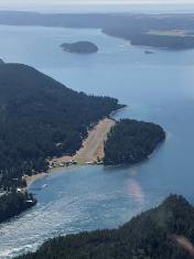
Blakely Island Airport
Official FAA Data Effective 2024-12-26 0901Z
VFR Chart of 38WA
Sectional Charts at SkyVector.com
IFR Chart of 38WA
Enroute Charts at SkyVector.com
Location Information for 38WA
Coordinates: N48°34.74' / W122°49.58'Located 00 miles NW of Blakely Island, Washington on 10 acres of land. View all Airports in Washington.
Surveyed Elevation is 66 feet MSL.
Operations Data
|
|
Airport Communications
| AWOS-3P at ORS (8.4 N): | 135.425 360-376-6045 |
|---|---|
| ASOS at FHR (8.6 SW): | 135.675 360-378-8491 |
| ASOS at NUW (15.2 SE): | 360-257-8813 |
Nearby Navigation Aids
|
| ||||||||||||||||||||||||||||||||||||||||||||||||||||||||||||
Runway 01/19
| Dimensions: | 2200 x 40 feet / 671 x 12 meters ADDNL 200 X 40' OVRNS & TURBC BOTH ENDS RWY 01/19. | |
|---|---|---|
| Surface: | Asphalt | |
| Edge Lighting: | Medium Intensity | |
| Runway 01 | Runway 19 | |
| Traffic Pattern: | Right | |
| Displaced Threshold: | 252 Feet | 122 Feet |
| Obstacles: | ft Trees 2000 ft from runway | ft Trees 2000 ft from runway |
Ownership Information
| Ownership: | Privately Owned | |
|---|---|---|
| Owner: | BLAKELY ISLAND MAINT COM | |
| 355 BLAKELY DR | ||
| BLAKELY ISLAND, WA 98222 | ||
| Manager: | DAN ROACH | |
| 466 MARINE DR | ||
| BLAKLEY ISLAND, WA 98222 | ||
| 206-276-3054 | ||
Other Remarks
- TREES BOTH SIDES OF RWY PENT TRSNL SFC.
- <WATCH FOR DEER ON RWY.
- <MIDDLE RY 01/19 HIGHER THAN EITHER END. CHECK ARPT TFC FM RUN-UP PAD CENTER OF FLD BEFORE TKOF.
- FOR CD CTC WHIDBEY APCH AT 360-257-3310.
- PHONE 206-276-3054 DECRRR@GMAIL.COM. SEC CTC RICH DOSS 360-622-8916.
- ACTVT MIRL RY 01/19 - 122.9.
- MULTICOM FREQ 122.9.
Nearby Airports with Instrument Procedures
| ID | Name | Heading / Distance | ||
|---|---|---|---|---|
 |
KORS | Orcas Island Airport | 336° | 8.5 |
 |
KFHR | Friday Harbor Airport | 246° | 8.6 |
 |
KNUW | Whidbey Island NAS (Ault Field) Airport | 153° | 15.2 |
 |
KBLI | Bellingham International Airport | 041° | 17.2 |
 |
KBVS | Skagit Regional Airport | 111° | 17.4 |
 |
KOKH | Delaurentis Airport | 162° | 20.6 |
 |
CYYJ | Victoria International Airport | 279° | 24.2 |
 |
0S9 | Jefferson County International Airport | 178° | 31.5 |
 |
CYXX | Abbotsford Airport | 034° | 32.6 |
 |
KNOW | Port Angeles CGAS Airport | 222° | 35.3 |
 |
KAWO | Arlington Municipal Airport | 133° | 36.6 |
 |
KCLM | William R Fairchild International Airport | 224° | 38.5 |


