Login
Register
CIU
Chippewa County International Airport
Official FAA Data Effective 2025-03-20 0901Z
VFR Chart of KCIU
Sectional Charts at SkyVector.com
IFR Chart of KCIU
Enroute Charts at SkyVector.com
Location Information for KCIU
Coordinates: N46°15.05' / W84°28.34'Located 15 miles S of Sault Ste Marie, Michigan on 1850 acres of land. View all Airports in Michigan.
Surveyed Elevation is 799 feet MSL.
Operations Data
|
|
Airport Communications
| AWOS-3PT: | 127.575 Tel. 906-495-1156 |
|---|---|
| CTAF: | 123.000 |
| UNICOM: | 123.000 |
| ASOS at ANJ (14.4 N): | 118.375 906-253-9523 |
| AWOS-3 at MCD (24.2 S): | 118.275 906-847-3778 |
| AWOS-3 at DRM (33.6 SE): | 118.325 906-493-6410 |
- APCH/DEP SVC PRVDD BY TORONTO ARTCC ON FREQS 132.65/344.5 (SAULT ENROUTE).
Nearby Navigation Aids
|
| ||||||||||||||||||||||||||||||||||||
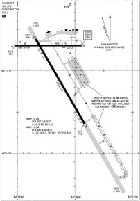
Runway 16/34
| Dimensions: | 7203 x 150 feet / 2195 x 46 meters | |
|---|---|---|
| Surface: | Asphalt-Concrete / Grooved in Fair Condition CNTR 150 FT IS ASPH, RMNG OUTSIDE EDGES ARE CONC. | |
| Weight Limits: | S-120, D-215, ST-369, DT-855
PCR VALUE: 680/R/B/W/T
| |
| Edge Lighting: | High Intensity | |
| Runway 16 | Runway 34 | |
| Coordinates: | N46°15.38' / W84°28.69' | N46°14.35' / W84°27.83' |
| Elevation: | 798.5 | 793.4 |
| Traffic Pattern: | Right | |
| Runway Heading: | 150° True | 330° True |
| Declared Distances: | TORA:7203 TODA:7203 ASDA:7203 LDA:7203 | TORA:7203 TODA:7203 ASDA:7203 LDA:7203 |
| Markings: | Precision Instrument in fair condition. | Precision Instrument in fair condition. |
| Glide Slope Indicator | P4L (3.00° Glide Path Angle) | P4L (3.00° Glide Path Angle) |
| Approach Lights: | MALSR 1,400 Foot Medium-intensity Approach Lighting System with runway alignment indicator lights. | |
| REIL: | Yes | |
Runway 10/28
| Dimensions: | 5001 x 75 feet / 1524 x 23 meters | |
|---|---|---|
| Surface: | Asphalt / Grooved in Good Condition | |
| Weight Limits: | S-55, D-88, ST-155
PCR VALUE: 200/F/B/X/T
| |
| Edge Lighting: | Medium Intensity | |
| Runway 10 | Runway 28 | |
| Coordinates: | N46°15.30' / W84°29.06' | N46°15.30' / W84°27.87' |
| Elevation: | 791.6 | 799.3 |
| Runway Heading: | 90° True | 270° True |
| Declared Distances: | TORA:5000 TODA:5000 ASDA:5000 LDA:5000 | TORA:5000 TODA:5000 ASDA:5000 LDA:5000 |
| Markings: | Non-Precision Instrument in fair condition. | Non-Precision Instrument in fair condition. |
| Glide Slope Indicator | P4L (3.00° Glide Path Angle) | P4L (3.00° Glide Path Angle) PAPI UNUSBL BYD 8 DEGS LEFT OF CNTRLN. |
| REIL: | Yes | Yes |
| Obstacles: | 57 ft Trees 1900 ft from runway, 50 ft left of center | 51 ft Trees 1800 ft from runway, 200 ft left of center |
Services Available
| Fuel: | 100LL (blue), Jet-A |
|---|---|
| Transient Storage: | Hangars,Tiedowns |
| Airframe Repair: | NOT AVAILABLE |
| Engine Repair: | NOT AVAILABLE |
| Bottled Oxygen: | NONE |
| Bulk Oxygen: | NONE |
Ownership Information
| Ownership: | Publicly owned | |
|---|---|---|
| Owner: | CHIPPEWA COUNTY ECON DEV CORP | |
| 5019 W AIRPORT DR | ||
| KINCHELOE, MI 49788-1643 | ||
| 906-495-5631 | ||
| Manager: | TAMI L BESEAU | |
| 5019 W AIRPORT DR | ||
| KINCHELOE, MI 49788-1643 | ||
| 906-495-5631 | AFT HRS CELL 906-322-3651. | |
Other Remarks
- BIRDS ON & INVOF ARPT.
- EXP SNOW REMOVAL ACT DLY DEC-MAR.
- VEHICLE TESTING INPR DRG WINTER MONTHS ON SECTIONS OF CLSD/ABNDD PARL TWY, SE OF APCH END RWY 34. AREA MAY BE PLOWED TO BARE SFC BUT UNAVBL FOR ARR OR DEP.
- FICONS UNMON 2100-0700.
- FOR CD IF UNA TO CTC ON FSS FREQ, CTC MINNEAPOLIS ARTCC AT 651-463-5588.
- ACTVT MALSR RWY 16; REIL RWY 34, 10, & 28; PAPI RWY 16, 34, 10, & 28; HIRL RWY 16/34; MIRL RWY 10/28 - CTAF. REIL & PAPI RWY 34 OPR CONSLY DEC-MAR; PAPI RWY 10 & 28 OPR CONSLY DRG DALGT HRS.
Weather Minimums
Instrument Approach Procedure (IAP) Charts
Nearby Airports with Instrument Procedures
| ID | Name | Heading / Distance | ||
|---|---|---|---|---|
 |
CYAM | Sault Ste Marie Airport | 353° | 14.1 |
 |
KANJ | Sault Ste Marie Municipal/Sanderson Field Airport | 017° | 14.4 |
 |
CPF2 | Bar River Airport | 056° | 18.5 |
 |
KMCD | Mackinac Island Airport | 196° | 24.2 |
 |
83D | Mackinac County Airport | 207° | 24.3 |
 |
6Y1 | Bois Blanc Island Airport | 182° | 29.1 |
 |
KDRM | Drummond Island Airport | 115° | 33.7 |
 |
KSLH | Cheboygan County Airport | 183° | 35.9 |
 |
KERY | Luce County Airport | 275° | 41.1 |
 |
KPLN | Pellston Regional/Emmet County Airport | 198° | 43.0 |
 |
KMGN | Harbor Springs Airport | 200° | 52.9 |
 |
KSJX | Beaver Island Airport | 234° | 56.7 |


