Login
Register
HTH
Hawthorne Industrial Airport
Official FAA Data Effective 2024-12-26 0901Z
VFR Chart of KHTH
Sectional Charts at SkyVector.com
IFR Chart of KHTH
Enroute Charts at SkyVector.com
Location Information for KHTH
Coordinates: N38°32.70' / W118°37.94'Located 01 miles N of Hawthorne, Nevada on 901 acres of land. View all Airports in Nevada.
Surveyed Elevation is 4230 feet MSL.
Operations Data
|
|
Airport Communications
| AWOS-3: | 120.225 Tel. 775-945-0727 |
|---|---|
| CTAF: | 122.800 |
| UNICOM: | 122.800 |
| ATIS at NFL (52.5 N): | 370.925 |
| AWOS-3 at MMH (56.1 S): | 118.05 760-934-6020 |
| AWOS-AV at FLX (57.6 N): | 118.25 775-423-2201 |
- COMMUNICATIONS PRVDD BY RENO RADIO ON FREQS 122.1R/114.1T (HAZEN RCO).
- APCH/DEP CTL SVC PRVDD BY OAKLAND ARTCC (ZOA) ON FREQS 125.75/284.65 (BISHOP RCAG).
Nearby Navigation Aids
|
| ||||||||||||||||||||||||||||||||||||
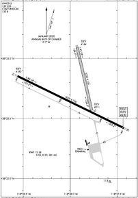
Runway 10/28
| Dimensions: | 6000 x 100 feet / 1829 x 30 meters | |
|---|---|---|
| Surface: | Asphalt in Good Condition | |
| Weight Limits: | S-53, D-93, ST-160 | |
| Edge Lighting: | Medium Intensity | |
| Runway 10 | Runway 28 | |
| Coordinates: | N38°32.85' / W118°38.56' | N38°32.42' / W118°37.43' |
| Elevation: | 4180.1 | 4230.4 |
| Traffic Pattern: | Left | Left |
| Markings: | Non-Precision Instrument in good condition. | Non-Precision Instrument in good condition. |
| Glide Slope Indicator | P2L (3.00° Glide Path Angle) PAPI UNUSBL BYD 7 DEGS RIGHT OF CNTRLN. DOES NOT PROVIDE OBSTRUCTION CLEARANCE BYD 6.0 NM FROM THR. | |
| REIL: | Yes | Yes |
Runway 15/33
| Dimensions: | 3250 x 130 feet / 991 x 40 meters | |
|---|---|---|
| Surface: | Dirt in Good Condition | |
| Runway 15 | Runway 33 | |
| Coordinates: | N38°33.09' / W118°37.93' | N38°32.57' / W118°37.77' |
| Elevation: | 4163.9 | 4211.0 |
| Traffic Pattern: | Left | Left |
| Markings: | None | None |
| Obstacles: | 23 ft Railroad 100 ft from runway | |
Services Available
| Fuel: | 100LL (blue), Jet-A, Jet A+ |
|---|---|
| Transient Storage: | Tiedowns |
| Airframe Repair: | NOT AVAILABLE |
| Engine Repair: | NOT AVAILABLE |
| Bottled Oxygen: | NOT AVAILABLE |
| Bulk Oxygen: | NOT AVAILABLE |
| Other Services: | AIR AMBULANCE SERVICES |
Ownership Information
| Ownership: | Publicly owned | |
|---|---|---|
| Owner: | MINERAL COUNTY | |
| PO BOX 1035 | ||
| HAWTHORNE, NV 89415 | ||
| 775-945-3897 | ||
| Manager: | DENNIS BUNCH | |
| 300 O STREET, PO BOX 1035 | ||
| HAWTHORNE, NV 89415 | ||
| (775) 312-0243 | ||
Other Remarks
- OCNL UAV/UAS ACT ON & INVOF ARPT.
- WILDLIFE ACT INVOF ARPT.
- FOR CD CTC OAKLAND ARTCC AT 510-745-3380.
- RWY BGNS AT N EDGE RWY 10/28.
- ACTVT REIL RWY 10 & 28; MIRL RWY 10/28 - CTAF. PAPI RWY 28 ON CONSLY.
Weather Minimums
Instrument Approach Procedure (IAP) Charts
Nearby Airports with Instrument Procedures
| ID | Name | Heading / Distance | ||
|---|---|---|---|---|
 |
O43 | Yerington Municipal Airport | 318° | 37.0 |
 |
KMMH | Mammoth Yosemite Airport | 190° | 56.1 |
 |
KFLX | Fallon Municipal Airport | 354° | 57.5 |
 |
KSPZ | Silver Springs Airport | 330° | 59.0 |
 |
KMEV | Minden-Tahoe Airport | 297° | 59.2 |
 |
KCXP | Carson City Airport | 307° | 64.5 |
 |
KTVL | Lake Tahoe Airport | 288° | 67.3 |
 |
KBIH | Bishop Airport | 169° | 71.4 |
 |
KRNO | Reno/Tahoe International Airport | 317° | 78.0 |
 |
KTPH | Tonopah Airport | 111° | 78.6 |
 |
E45 | Pine Mountain Lake Airport | 241° | 83.8 |
 |
KTRK | Truckee-Tahoe Airport | 303° | 84.5 |


