Login
Register
MCC
Mc Clellan Airfield Airport
Official FAA Data Effective 2024-12-26 0901Z
VFR Chart of KMCC
Sectional Charts at SkyVector.com
IFR Chart of KMCC
Enroute Charts at SkyVector.com
Location Information for KMCC
Coordinates: N38°40.06' / W121°24.04'Located 06 miles NE of Sacramento, California. View all Airports in California.
Surveyed Elevation is 76 feet MSL.
Operations Data
|
|
Airport Communications
| AWOS-3: | 125.975 Tel. 916-641-1272 |
|---|---|
| NORCAL APPROACH: | 127.4 317.5 |
| NORCAL DEPARTURE: | 127.4 317.5 |
| CLEARANCE DELIVERY: | 119.825 |
| UNICOM: | 122.975 |
| CTAF: | 122.975 |
| ATIS at MHR (8.3 SE): | 118.325 |
| AWOS-3PT at MHR (8.3 SE): | 118.325 916-366-3371 |
| D-ATIS at SMF (9.1 W): | 126.75 |
- MILITARY USE: PMSV METRO - 344.6 REMARKS: PART TIME.
- USCG COMSTA SAN FRAN - OPR 0500-1100Z++. 3123 5696 8984 11201
- USCG SACRAMENTO - 167.9 345.0.
Nearby Navigation Aids
|
| ||||||||||||||||||||||||||||||||||||
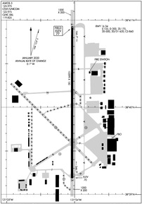
Runway 16/34
| Dimensions: | 10599 x 150 feet / 3231 x 46 meters | |
|---|---|---|
| Surface: | Concrete / Grooved in Good Condition | |
| Weight Limits: | S-155, D-300, ST-500 | |
| Edge Lighting: | High Intensity NSTD HIRL LCTD 25 FT FM RY EDGE MARKINGS. | |
| Runway 16 | Runway 34 | |
| Coordinates: | N38°40.93' / W121°24.03' | N38°39.19' / W121°24.04' |
| Elevation: | 76.8 | 69.9 |
| Traffic Pattern: | Right | Left |
| Runway Heading: | 180° True | 0 |
| Markings: | Precision Instrument in good condition. | Precision Instrument in good condition. |
| Glide Slope Indicator | P4L (3.00° Glide Path Angle) | P4L (3.00° Glide Path Angle) |
| Approach Lights: | MALSR 1,400 Foot Medium-intensity Approach Lighting System with runway alignment indicator lights. | |
| Obstacles: | 90 ft Tower 4000 ft from runway, 175 ft left of center | |
Helipad H1
| Dimensions: | 57 x 57 feet / 17 x 17 meters | |
|---|---|---|
| Surface: | Concrete | |
| Coordinates: | N38°39.78' / W121°23.83' | N0°0.00' / E0°0.00' |
| Elevation: | 76.0 | |
| Markings: | Non-Standard | |
Helipad H2
| Dimensions: | 57 x 57 feet / 17 x 17 meters | |
|---|---|---|
| Surface: | Concrete | |
| Coordinates: | N38°39.77' / W121°24.26' | N0°0.00' / E0°0.00' |
| Elevation: | 67.0 | |
Helipad H3
| Dimensions: | 57 x 57 feet / 17 x 17 meters | |
|---|---|---|
| Surface: | Asphalt | |
| Coordinates: | N38°39.46' / W121°24.23' | N0°0.00' / E0°0.00' |
| Elevation: | 67.0 | |
Helipad H4
| Dimensions: | 57 x 57 feet / 17 x 17 meters | |
|---|---|---|
| Surface: | Concrete | |
| Coordinates: | N38°39.15' / W121°24.15' | N0°0.00' / E0°0.00' |
| Elevation: | 68.0 | |
Services Available
| Fuel: | 100LL (blue), Jet-A, Jet A+ |
|---|---|
| Transient Storage: | Hangars,Tiedowns |
| Airframe Repair: | MAJOR |
| Engine Repair: | MAJOR |
| Bottled Oxygen: | NONE |
| Bulk Oxygen: | HIGH/LOW |
| Other Services: | AIR FREIGHT SERVICES,AIR AMBULANCE SERVICES,AVIONICS,CARGO HANDLING SERVICES,CHARTER SERVICE,AIRCRAFT SALES |
Ownership Information
| Ownership: | Privately Owned | |
|---|---|---|
| Owner: | MC CLELLAN BUSINESS PARK, LLC | |
| 3028 PEACEKEEPER WAY | ||
| MCCLELLAN, CA 95652-2502 | ||
| 916-570-5317 | ||
| Manager: | JOSHUA HENRY | |
| 3028 PEACEKEEPER WAY | ||
| MCCLELLAN, CA 95652-2502 | ||
| 916-570-5317 | ||
Other Remarks
- 900 FT ASPH OVRN SE END RY 16 & 1000 FT ASPH OVRN NW END RY 34.
- MILITARY USE: TRAN ACFT PPR FOR USCG RAMP C916-643-7659, WITH CREW LIST FOR ARR/DEP PAX.
- RY 16 CALM WIND RWY.
- TWYS E,F,G NSTD TWY EDGE LGTG.
- FOR CD CTC NORCAL APCH AT 916-361-6874.
- FLD CONDS-RWY, TWY & APRON GOOD.
- STRICT ADHERENCE TO PUBLD TFC PATS RCMD FOR NS ABTMT PURPOSES.
- TOUCH/GO LNDG FOR C5 PROHIBITED.
- DURG INCREASED BIRD CONDITIONS THE POTENTIAL FOR BIRD CONGESTION EXIST AT BOTH ARR/DEP ENDS RY 16/34.
- ALL ACFT EXIT RY TO THE EAST. SELF SRV 100LL W SIDE TW KILO.
- MILITARY USE: FUEL - A+ (MCCLELLAN JET SVC, C916-641-8970.)
- MILITARY MARKINGS ON AIRFIELD.
- 0LL SELF-SERVICE 100LL FUEL WEST SIDE TWY KILO.
- ACTVT MALSR RWY 16; HIRL RWY 16/34; TWY LGTS - CTAF. PAPI RWYS 16 & 34 OPR CONSLY.
Instrument Approach Procedure (IAP) Charts
Nearby Airports with Instrument Procedures
| ID | Name | Heading / Distance | ||
|---|---|---|---|---|
 |
KMHR | Sacramento Mather Airport | 144° | 8.3 |
 |
KSMF | Sacramento International Airport | 280° | 9.1 |
 |
KSAC | Sacramento Exec Airport | 205° | 10.3 |
 |
KLHM | Lincoln Regional/Karl Harder Field Airport | 009° | 14.7 |
 |
KEDU | University Airport | 245° | 19.9 |
 |
KDWA | Yolo County Airport | 256° | 22.1 |
 |
O41 | Watts-Woodland Airport | 271° | 22.2 |
 |
KAUN | Auburn Municipal Airport | 040° | 22.8 |
 |
KMYV | Yuba County Airport | 342° | 27.0 |
 |
KBAB | Beale AFB Airport | 356° | 28.1 |
 |
1O3 | Lodi Airport | 167° | 28.6 |
 |
KPVF | Placerville Airport | 083° | 30.6 |


