Login
Register
PLN
Pellston Regional/Emmet County Airport
Official FAA Data Effective 2024-11-28 0901Z
VFR Chart of KPLN
Sectional Charts at SkyVector.com
IFR Chart of KPLN
Enroute Charts at SkyVector.com
Location Information for KPLN
Coordinates: N45°34.26' / W84°47.80'Located 01 miles NW of Pellston, Michigan on 1675 acres of land. View all Airports in Michigan.
Surveyed Elevation is 720 feet MSL.
Operations Data
|
|
Airport Communications
| ASOS: | 119.025 Tel. 231-539-7700 |
|---|---|
| CTAF: | 123.000 |
| UNICOM: | 123.000 |
| AWOS-3P at MGN (10.1 SW): | 119.925 231-347-5231 |
| AWOS-3 at SLH (12.6 E): | 118.175 231-627-4671 |
| AWOS-3 at MCD (18.9 N): | 118.275 906-847-3778 |
- APCH/DEP SVC PRVDD BY MINNEAPOLIS ARTCC ON FREQS 134.6/354.05 (PELLSTON RCAG).
- COMMUNICATIONS PRVDD BY LANSING RADIO ON FREQ 122.2 (PELLSTON RCO).
Nearby Navigation Aids
|
| ||||||||||||||||||||||||||||||||||||||||||||||||||||||||||||
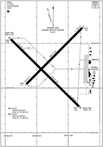
Runway 14/32
| Dimensions: | 6513 x 150 feet / 1985 x 46 meters | |
|---|---|---|
| Surface: | Asphalt / Grooved in Good Condition | |
| Weight Limits: | 25 /F/B/X/U, S-76, D-115, ST-215 | |
| Edge Lighting: | High Intensity | |
| Runway 14 | Runway 32 | |
| Coordinates: | N45°34.55' / W84°48.41' | N45°33.79' / W84°47.33' |
| Elevation: | 718.0 | 707.5 |
| Traffic Pattern: | Left | Left |
| Runway Heading: | 135° True | 315° True |
| Declared Distances: | TORA:6513 TODA:6513 ASDA:6512 LDA:6512 | TORA:6513 TODA:6513 ASDA:6513 LDA:6513 |
| Markings: | Precision Instrument in fair condition. | Precision Instrument in fair condition. |
| Glide Slope Indicator | P4L (3.00° Glide Path Angle) UNUSBL BYD 8 DEGS RIGHT OF CNTRLN. | |
| Approach Lights: | MALSR 1,400 Foot Medium-intensity Approach Lighting System with runway alignment indicator lights. | |
| REIL: | Yes | |
| Obstacles: | 82 ft Trees 2850 ft from runway | 56 ft Tree 2739 ft from runway, 865 ft left of center |
Runway 05/23
| Dimensions: | 5401 x 150 feet / 1646 x 46 meters | |
|---|---|---|
| Surface: | Asphalt / Grooved in Good Condition | |
| Weight Limits: | 25 /F/B/X/U, S-76, D-115, ST-215 | |
| Edge Lighting: | Medium Intensity | |
| Runway 05 | Runway 23 | |
| Coordinates: | N45°34.04' / W84°48.17' | N45°34.68' / W84°47.28' |
| Elevation: | 710.6 | 720.5 |
| Traffic Pattern: | Left | Left |
| Runway Heading: | 45° True | 225° True |
| Declared Distances: | TORA:5395 TODA:5395 ASDA:5395 LDA:5395 | TORA:5395 TODA:5395 ASDA:5395 LDA:5395 |
| Markings: | Non-Precision Instrument in good condition. | Non-Precision Instrument in good condition. |
| Glide Slope Indicator | V4R (3.00° Glide Path Angle) | V4L (3.00° Glide Path Angle) |
| REIL: | Yes | Yes |
| Obstacles: | 50 ft Trees 1500 ft from runway, 300 ft right of center | 18 ft Road 669 ft from runway, 316 ft right of center |
Services Available
| Fuel: | 100LL (blue), Jet-A |
|---|---|
| Transient Storage: | Tiedowns |
| Airframe Repair: | MAJOR |
| Engine Repair: | MAJOR |
| Bottled Oxygen: | NONE |
| Bulk Oxygen: | NONE |
| Other Services: | CHARTER SERVICE |
Ownership Information
| Ownership: | Publicly owned | |
|---|---|---|
| Owner: | EMMET COUNTY | |
| 1395 N US HIGHWAY 31 | ||
| PELLSTON, MI 49769-9307 | ||
| 231-539-8441 | ||
| Manager: | RYAN BACHELOR | |
| 1395 N US HIGHWAY 31 | ||
| PELLSTON, MI 49769-9307 | ||
| 231-539-8442 | ||
Other Remarks
- DEER & GULLS OCNLY ON & INVOF ARPT.
- BE ALERT FOR SNOW REMOVAL EQUIP & ACTIVITY ON & INVOF RYS DURG WINTER MONTHS.
- TWY B1 & E1 CLSD 1 NOV THRU 15 APR..
- SFC CONDS UNMON 2300-0530 DLY.
- FOR CD IF UNA TO CTC ON FSS FREQ, CTC MINNEAPOLIS ARTCC AT 651-463-5588.
- ACTVT MALSR RWY 32; REIL RWY 14, 05, & 23; PAPI RWY 14; HIRL RWY 14/32; MIRL RWY 05/23 - CTAF. VASI RWY 05 & 23 OPR CONSLY.
Weather Minimums
Instrument Approach Procedure (IAP) Charts
Nearby Airports with Instrument Procedures
| ID | Name | Heading / Distance | ||
|---|---|---|---|---|
 |
KMGN | Harbor Springs Airport | 209° | 10.0 |
 |
KSLH | Cheboygan County Airport | 066° | 12.7 |
 |
6Y1 | Bois Blanc Island Airport | 046° | 17.0 |
 |
KMCD | Mackinac Island Airport | 020° | 18.9 |
 |
83D | Mackinac County Airport | 007° | 19.4 |
 |
N98 | Boyne City Municipal Airport | 200° | 23.2 |
 |
KBFA | Boyne Mountain Airport | 192° | 24.9 |
 |
KCVX | Charlevoix Municipal Airport | 231° | 25.8 |
 |
KSJX | Beaver Island Airport | 282° | 33.2 |
 |
KGLR | Gaylord Regional Airport | 173° | 33.7 |
 |
KACB | Antrim County Airport | 206° | 38.9 |
 |
KPZQ | Presque Isle County Airport | 102° | 42.7 |


