Login
Register
RKS
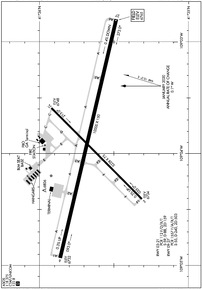
Southwest Wyoming Regional Airport
Official FAA Data Effective 2024-10-31 0901Z
VFR Chart of KRKS
Sectional Charts at SkyVector.com
IFR Chart of KRKS
Enroute Charts at SkyVector.com
Location Information for KRKS
Coordinates: N41°35.65' / W109°3.91'Located 07 miles E of Rock Springs, Wyoming on 1242 acres of land. View all Airports in Wyoming.
Surveyed Elevation is 6764 feet MSL.
Operations Data
|
|
Airport Communications
| ASOS: | 118.375 Tel. 307-362-2541 |
|---|---|
| UNICOM: | 122.800 |
| CTAF: | 122.800 |
| AWOS-3PT at 40U (45.7 SW): | 119.250 435-784-3123 |
| AWOS-3PT at FWZ (56.7 N): | 118.350 307-709-2644 |
| AWOS-3PT at FBR (61.5 W): | 118.8 307-782-3226 |
- COMMUNICATIONS PRVDD BY CASPER RADIO ON FREQ 122.2 (ROCK SPRINGS RCO).
- APCH/DEP CTL SVC PRVDD BY SALT LAKE ARTCC (ZLC) ON 124.35/353.5 (GREEN RIVER RCAG).
Nearby Navigation Aids
|
| ||||||||||||||||||||||||||||||||||||
Runway 09/27
| Dimensions: | 10000 x 150 feet / 3048 x 46 meters | |
|---|---|---|
| Surface: | Asphalt / Grooved in Good Condition | |
| Weight Limits: | S-55, D-240, ST-503
PCR VALUE: 1557/F/A/X/T
| |
| Edge Lighting: | High Intensity | |
| Runway 09 | Runway 27 | |
| Coordinates: | N41°35.86' / W109°4.93' | N41°35.48' / W109°2.80' |
| Elevation: | 6731.7 | 6764.5 |
| Traffic Pattern: | Left | Left |
| Runway Heading: | 103° True | 283° True |
| Declared Distances: | TORA:10000 TODA:10000 ASDA:10000 LDA:10000 | TORA:10000 TODA:10000 ASDA:10000 LDA:10000 |
| Markings: | Precision Instrument in good condition. | Precision Instrument in good condition. |
| Glide Slope Indicator | P4L (3.00° Glide Path Angle) | P4L (3.00° Glide Path Angle) |
| Approach Lights: | ODALS Omnidirectional Approach Lighting System | MALSR 1,400 Foot Medium-intensity Approach Lighting System with runway alignment indicator lights. |
Runway 03/21
| Dimensions: | 5228 x 75 feet / 1593 x 23 meters | |
|---|---|---|
| Surface: | Asphalt / Porous Friction Course in Good Condition | |
| Weight Limits: | S-59, D-88, ST-159
PCR VALUE: 112/F/D/X/T.
| |
| Edge Lighting: | Medium Intensity | |
| Runway 03 | Runway 21 | |
| Coordinates: | N41°35.31' / W109°4.41' | N41°35.92' / W109°3.59' |
| Elevation: | 6733.9 | 6748.0 |
| Runway Heading: | 45° True | 225° True |
| Declared Distances: | TORA:5228 TODA:5228 ASDA:5228 LDA:5228 | TORA:5228 TODA:5228 ASDA:5228 LDA:5228 |
| Markings: | Basic in good condition. | Basic in good condition. |
| Glide Slope Indicator | P2L (3.00° Glide Path Angle) | P2L (3.00° Glide Path Angle) |
| REIL: | Yes | Yes |
Services Available
| Fuel: | 100LL (blue), Jet A-1+ |
|---|---|
| Transient Storage: | Hangars,Tiedowns |
| Airframe Repair: | MINOR |
| Engine Repair: | MINOR |
| Bottled Oxygen: | HIGH/LOW |
| Bulk Oxygen: | NOT AVAILABLE |
| Other Services: | AIR FREIGHT SERVICES,AIR AMBULANCE SERVICES,CARGO HANDLING SERVICES,CHARTER SERVICE,PILOT INSTRUCTION,AIRCRAFT RENTAL |
Ownership Information
| Ownership: | Publicly owned | |
|---|---|---|
| Owner: | ROCK SPRINGS/SWEETWATER COUNTY | ROCK SPRINGS/SWEETWATER CO ARPT JOINT PWRS BOARDS |
| BOX 1987 | ||
| ROCK SPRINGS, WY 82902-1987 | ||
| 307-352-6880 | ||
| Manager: | DEVON BRUBAKER | |
| 382 HWY 370 | ||
| ROCK SPRINGS, WY 82901-1987 | ||
| 307-352-6880 | ||
Other Remarks
- FOR CD IF UNA TO CTC ON FSS FREQ, CTC SALT LAKE ARTCC AT 801-320-2568.
- ACTVT MALSR RWY 27; ODALS RWY 09; REIL RWY 03 & 21; HIRL RWY 09/27 & TWY LGTS - CTAF. PAPI RWY 09, 27, 03, 21 OPR CONSLY.
Weather Minimums
Instrument Approach Procedure (IAP) Charts
Nearby Airports with Instrument Procedures
| ID | Name | Heading / Distance | ||
|---|---|---|---|---|
 |
KFBR | Fort Bridger Airport | 259° | 61.6 |
 |
KEMM | Kemmerer Municipal Airport | 282° | 68.4 |
 |
KVEL | Vernal Regional Airport | 196° | 72.3 |
 |
KLND | Hunt Field Airport | 011° | 74.8 |
 |
KBPI | Miley Memorial Field Airport | 322° | 75.4 |
 |
KDWX | Dixon Airport | 114° | 78.6 |
 |
KPNA | Ralph Wenz Field Airport | 335° | 79.5 |
 |
KRWL | Rawlins Municipal/Harvey Field Airport | 080° | 84.8 |
 |
KEVW | Evanston-Uinta County Burns Field Airport | 258° | 90.9 |
 |
74V | Roosevelt Municipal Airport | 209° | 90.8 |
 |
4V0 | Rangely Airport | 171° | 91.0 |
 |
KRIW | Central Wyoming Regional Airport | 016° | 92.2 |


