Login
Register


M70
Pocahontas Municipal Airport
Official FAA Data Effective 2024-04-18 0901Z
Chart Supplement

VFR Chart of M70
Sectional Charts at SkyVector.com
IFR Chart of M70
Enroute Charts at SkyVector.com
Location Information for M70
Coordinates: N36°14.73' / W90°57.31'Located 01 miles SE of Pocahontas, Arkansas on 188 acres of land. View all Airports in Arkansas.
Surveyed Elevation is 273 feet MSL.
Operations Data
|
|
Airport Communications
| UNICOM: | 122.800 |
|---|---|
| CTAF: | 122.800 |
| AWOS-3PT at ARG (7.4 S): | 126.525 870-886-2537 |
| AWOS-3T at 4M9 (17.7 NE): | 118.325 870-857-9702 |
| ASOS at JBR (28.9 SE): | 118.525 870-932-4010 |
- APCH/DEP SVC PRVDD BY MEMPHIS ARTCC ON FREQS 120.075/289.4 (WALNUT RIDGE RCAG).
Nearby Navigation Aids
|
| ||||||||||||||||||||||||||||||||||||||||||||||||||||||||||||


Runway 18/36
| Dimensions: | 4000 x 75 feet / 1219 x 23 meters | |
|---|---|---|
| Surface: | Asphalt in Fair Condition | |
| Weight Limits: | S-19 | |
| Edge Lighting: | Medium Intensity | |
| Runway 18 | Runway 36 | |
| Coordinates: | N36°15.06' / W90°57.31' | N36°14.40' / W90°57.32' |
| Elevation: | 271.6 | 271.4 |
| Traffic Pattern: | Left | Left |
| Runway Heading: | 181° True | 1° True |
| Markings: | Non-Precision Instrument in fair condition. | Non-Precision Instrument in fair condition. |
| Glide Slope Indicator | P2L (3.00° Glide Path Angle) | P2L (3.00° Glide Path Angle) |
| REIL: | Yes | Yes |
| Obstacles: | 38 ft Tree 660 ft from runway, 330 ft right of center | 15 ft Road 480 ft from runway |
Services Available
| Fuel: | 100LL (blue), Jet-A |
|---|---|
| Transient Storage: | Tiedowns |
| Airframe Repair: | MAJOR |
| Engine Repair: | MAJOR |
| Bottled Oxygen: | NONE |
| Bulk Oxygen: | NONE |
| Other Services: | CROP DUSTING SERVICES,AIR AMBULANCE SERVICES,PILOT INSTRUCTION |
Ownership Information
| Ownership: | Publicly owned | |
|---|---|---|
| Owner: | CITY OF POCAHONTAS | |
| PO BOX 896 | ||
| POCAHONTAS, AR 72455 | ||
| 870-892-3924 | ||
| Manager: | MICHELLE ANTHONEY | |
| 2006 AIRWAYS LANE | ||
| POCAHONTAS, AR 72455 | ||
| 870-248-1141 | ||
Operational Statistics
| Single Engine Aircraft Based on Field: | 18 | Statistics collected for 12 month period ending 2022-12-31 | |
|---|---|---|---|
| Multi-Engine Aircraft Based on Field: | 2 | Annual Commercial Operations: | none |
| Jet Aircraft Based on Field: | none | Annual Commuter Operations: | none |
| Helicopters Based on Field: | 1 | Annual Air Taxi Operations: | none |
| Military Aircraft Based on Field: | none | Annual Military Operations: | none |
| Gliders Based on Field: | none | Annual GA Local Operations: | 12000 |
| Ultralights Based on Field: | none | Annual GA Itinerant Operations: | 1200 |
Other Remarks
- FOR CD CTC MEMPHIS ARTCC AT 901-368-8453/8449.
- 0LL 24 HR SELF SVC FUEL AVBL WITH CREDIT CARD (100LL & JET A)
- FULL SVC AVBL (JET A).
- ACTVT REIL RWY 18 & 36; MIRL RWY 18/36 - CTAF. PAPI RWY 18 & 36 OPER CONS.
Weather Minimums

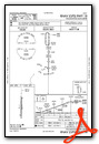
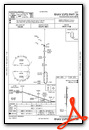
Instrument Approach Procedure (IAP) Charts
Nearby Airports with Instrument Procedures
| ID | Name | Heading / Distance | ||
|---|---|---|---|---|
 |
KARG | Walnut Ridge Regional Airport | 168° | 7.4 |
|
4M9 | Corning Municipal Airport | 057° | 17.7 |
|
KPGR | Kirk Field Airport | 116° | 24.3 |
|
KJBR | Jonesboro Municipal Airport | 148° | 29.0 |
|
KCVK | Sharp County Regional Airport | 272° | 29.5 |
|
M19 | Newport Regional Airport | 196° | 38.0 |
|
6M2 | Horseshoe Bend Airport | 268° | 38.9 |
|
42A | Melbourne Municipal - John E Miller Field Airport | 256° | 43.8 |
|
KPOF | Poplar Bluff Regional Business Airport | 043° | 44.0 |
|
KMXA | Manila Municipal Airport | 118° | 44.3 |
|
KTKX | Kennett Memorial Airport | 091° | 44.6 |
|
KBVX | Batesville Regional Airport | 227° | 45.9 |
Airport Images
Do you have a recent image of this airport? Upload it here!


