Login
Register


16VA
Echols Field Airport
Official FAA Data Effective 2026-01-22 0901Z
VFR Chart of 16VA
Sectional Charts at SkyVector.com
IFR Chart of 16VA
Enroute Charts at SkyVector.com
Location Information for 16VA
Coordinates: N38°20.07' / W79°9.63'Located 04 miles W of Mount Solon, Virginia. View all Airports in Virginia.
Estimated Elevation is 1782 feet MSL.
Operations Data
|
|
Airport Communications
| AWOS-3 at VBW (9.6 E): | 119.55 540-828-2076 |
|---|---|
| AWOS-3 at SHD (13.0 E): | 124.925 540-234-0110 |
| AWOS-3PT at W13 (18.5 SE): | 118.625 540-941-7570 |
Nearby Navigation Aids
|
| ||||||||||||||||||||||||||||||||||||||||||||||||||||||||||||


Runway 05/23
| Dimensions: | 1650 x 50 feet / 503 x 15 meters | |
|---|---|---|
| Surface: | Turf-Dirt in Fair Condition | |
| Runway 05 | Runway 23 | |
Ownership Information
| Ownership: | Privately Owned | |
|---|---|---|
| Owner: | YELLOW JACKET HOLLOW | |
| 1116 STRIBLING SPRINGS RD | ||
| MOUNT SOLON, VA 22843 | ||
| 443-629-2630 | ||
| Manager: | JEREMY WIMPEY | |
| 1165 LOTTS RD | ||
| STEELES TAVERN, VA 24476 | ||
| 443 629 2630 | ||
Nearby Airports with Instrument Procedures
| ID | Name | Heading / Distance | ||
|---|---|---|---|---|
 |
KVBW | Bridgewater Air Park Airport | 078° | 9.7 |
|
KSHD | Shenandoah Valley Regional Airport | 108° | 13.2 |
|
W13 | Eagle's Nest Airport | 146° | 18.5 |
|
8W2 | New Market Airport | 047° | 28.7 |
|
KCHO | Charlottesville-Albemarle Airport | 109° | 35.5 |
|
KLUA | Luray Caverns Airport | 057° | 36.9 |
|
KHSP | Ingalls Field Airport | 234° | 39.3 |
|
W99 | Grant County Airport | 000° | 39.6 |
|
KEKN | Elkins/Randolph County (Jennings Randolph Field) Airport | 315° | 46.7 |
|
KGVE | Gordonsville Municipal Airport | 102° | 48.2 |
|
KOMH | Orange County Airport | 095° | 52.9 |
|
KFRR | Front Royal-Warren County Airport | 050° | 55.1 |
Airport Images
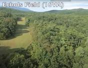
By: Big Orange Bird


