Login
Register


S24
Sandusky County Regional Airport
Official FAA Data Effective 2026-02-19 0901Z
Chart Supplement

VFR Chart of S24
Sectional Charts at SkyVector.com
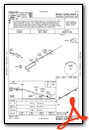
IFR Chart of S24
Enroute Charts at SkyVector.com
Location Information for S24
Coordinates: N41°17.74' / W83°2.23'Located 05 miles SE of Fremont, Ohio on 589 acres of land. View all Airports in Ohio.
Surveyed Elevation is 664 feet MSL.
Operations Data
|
|
Airport Communications
| AWOS-3P: | 119.575 Tel. 419-547-6932 |
|---|---|
| TOLEDO APPROACH: | 126.1 307.0 |
| TOLEDO DEPARTURE: | 126.1 307.0 |
| UNICOM: | 123.050 |
| CTAF: | 123.050 |
| AWOS-3 at 16G (14.5 SW): | 127.175 419-443-1043 |
| AWOS-3 at PCW (15.4 NE): | 118.775 419-734-9955 |
| AWOS-3 at FZI (17.3 W): | 124.625 419-436-0053 |
Nearby Navigation Aids
|
| ||||||||||||||||||||||||||||||||||||||||||||||||||||||||||||


Runway 06/24
| Dimensions: | 5500 x 100 feet / 1676 x 30 meters | |
|---|---|---|
| Surface: | Asphalt / Grooved in Good Condition | |
| Weight Limits: | S-30 | |
| Edge Lighting: | Medium Intensity | |
| Runway 06 | Runway 24 | |
| Coordinates: | N41°17.52' / W83°2.75' | N41°17.97' / W83°1.71' |
| Elevation: | 664.2 | 655.9 |
| Runway Heading: | 60° True | 240° True |
| Markings: | Non-Precision Instrument in fair condition. | Non-Precision Instrument in fair condition. |
| Glide Slope Indicator | P4L (3.00° Glide Path Angle) | P4L (3.00° Glide Path Angle) |
| REIL: | Yes | Yes |
| Obstacles: | 85 ft Tree 2478 ft from runway, 30 ft left of center | |
Services Available
| Fuel: | 100LL (blue), Jet A+ |
|---|---|
| Transient Storage: | Hangars,Tiedowns |
| Airframe Repair: | NONE |
| Engine Repair: | NONE |
| Bottled Oxygen: | NONE |
| Bulk Oxygen: | NONE |
| Other Services: | AIR AMBULANCE SERVICES |
Ownership Information
| Ownership: | Publicly owned | |
|---|---|---|
| Owner: | SANDUSKY COUNTY | |
| 1500 COUNTY ROAD 220 | ||
| CLYDE, OH 43410-9562 | ||
| 419-547-0131 | ||
| Manager: | MICHAEL RUSSELL | MANAGER@SANDUSKYCOUNTYAIRPORT.COM. |
| 1500 COUNTY ROAD 220 | ||
| CLYDE, OH 43410-9562 | ||
| 419-547-0131 | ||
Other Remarks
- THIS AIRPORT HAS BEEN SURVEYED BY THE NATIONAL GEODETIC SURVEY.
- BIRDS & DEER ON & INVOF ARPT.
- FOR CD CTC TOLEDO APCH AT 419-865-1495.
- 0LL 100LL & JET A+ AVBL H24 SELF SVC VIA CREDIT CARD.
- ACTVT REIL RWY 06 & 24; PAPI RWY 06 & 24; MIRL RWY 06/24 - CTAF.
Weather Minimums

Instrument Approach Procedure (IAP) Charts

Nearby Airports with Instrument Procedures
| ID | Name | Heading / Distance | ||
|---|---|---|---|---|
 |
14G | Fremont Airport | 291° | 6.0 |
|
16G | Seneca County Airport | 213° | 14.5 |
|
KPCW | Erie-Ottawa International Airport | 029° | 15.2 |
|
KFZI | Donald P Miller Airport | 248° | 17.3 |
|
8G1 | Willard Airport | 137° | 20.9 |
|
5A1 | Norwalk/Huron County Airport | 097° | 22.2 |
|
KTDZ | Toledo Exec Airport | 308° | 25.8 |
|
1G0 | Wood County Airport | 282° | 27.4 |
|
56D | Wyandot County Airport | 207° | 27.7 |
|
17G | Port Bucyrus/Crawford County Airport | 174° | 31.0 |
|
KFDY | Findlay Airport | 239° | 33.3 |
|
KGQQ | Galion Municipal Airport | 156° | 35.5 |
Airport Images
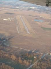
By: willele


