Login
Register
1S2
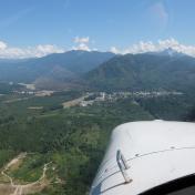
Darrington Municipal Airport
Official FAA Data Effective 2026-01-22 0901Z
VFR Chart of 1S2
Sectional Charts at SkyVector.com
IFR Chart of 1S2
Enroute Charts at SkyVector.com
Location Information for 1S2
Coordinates: N48°15.52' / W121°36.61'Located 00 miles N of Darrington, Washington on 90 acres of land. View all Airports in Washington.
Estimated Elevation is 553 feet MSL.
Operations Data
|
|
Airport Communications
| CTAF: | 122.900 |
|---|---|
| AWOS-3PT at AWO (22.8 W): | 135.625 360-435-8045 |
| ASOS at PAE (33.7 SW): | 425-355-6192 |
| ATIS at PAE (34.2 SW): | 128.65 |
Nearby Navigation Aids
|
| ||||||||||||||||||||||||||||||||||||||||||||||||
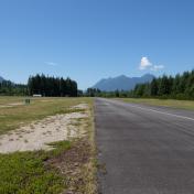
Runway 10/28
| Dimensions: | 2491 x 40 feet / 759 x 12 meters | |
|---|---|---|
| Surface: | Asphalt in Good Condition | |
| Edge Lighting: | Medium Intensity MIRL RY 10/28 OTS INDEFLY. | |
| Runway 10 | Runway 28 | |
| Coordinates: | N48°15.59' / W121°36.90' | N48°15.44' / W121°36.33' |
| Elevation: | 544.0 | 553.0 |
| Traffic Pattern: | Left | Left |
| Runway Heading: | 111° True | 291° True |
| Markings: | Basic in good condition. | Basic in good condition. |
| Obstacles: | 65 ft Trees 905 ft from runway FENCE AT 40 FT, 104 FT R; 3 FT SIGN, 65 FT R, 29 FT FM THLD. |
15 ft Road 305 ft from runway, 126 ft left of center LOGS 78 FT R, ROAD 90 FT R, 35 FT TREES 118 FT R. |
Services Available
| Fuel: | NONE |
|---|---|
| Transient Storage: | Tiedowns PILOTS BRING OWN TIE-DOWNS. |
| Airframe Repair: | NONE |
| Engine Repair: | NONE |
| Bottled Oxygen: | NONE |
| Bulk Oxygen: | NONE |
Ownership Information
| Ownership: | Publicly owned | |
|---|---|---|
| Owner: | TOWN OF DARRINGTON | |
| P.O. BOX 397 | ||
| DARRINGTON, WA 98241 | ||
| 360-436-1131 | ||
| Manager: | JIM HALE | |
| P.O. BOX 312 | ||
| DARRINGTON, WA 98241 | ||
| 360-631-1928 | MANAGER'S CELL PHONE NUMBER IS 360-631-1928. | |
Other Remarks
- CLSD WHEN SNOW ON RY.
- TURB ON HOT DAYS LNDG W IN TRSN EAST APPROACH.
- TWYS MARKED WITH BLUE REFLECTORS.
- FOR CD CTC SEATTLE ARTCC AT 253-351-3694.
- TWYS ROUGH PAVEMENT WITH SWALES AND DEPRESSIONS.
- ACTVT MIRL RWY 10/28 - CTAF.
Nearby Airports with Instrument Procedures
| ID | Name | Heading / Distance | ||
|---|---|---|---|---|
 |
KAWO | Arlington Municipal Airport | 255° | 22.8 |
 |
S43 | Harvey Field Airport | 223° | 29.0 |
 |
KPAE | Seattle Paine Field International Airport | 232° | 34.3 |
 |
KBVS | Skagit Regional Airport | 291° | 34.9 |
 |
KNUW | Whidbey Island NAS (Ault Field) Airport | 278° | 42.3 |
 |
KOKH | Delaurentis Airport | 269° | 42.6 |
 |
KBLI | Bellingham International Airport | 311° | 49.0 |
 |
0S9 | Jefferson County International Airport | 256° | 49.8 |
 |
KBFI | Boeing Field/King County International Airport | 212° | 51.9 |
 |
KRNT | Renton Municipal Airport | 208° | 52.1 |
 |
CYXX | Abbotsford Airport | 327° | 54.9 |
 |
KSEA | Seattle-Tacoma International Airport | 210° | 56.2 |


