Login
Register


23R
Devine Municipal Airport
Official FAA Data Effective 2026-02-19 0901Z
Chart Supplement

VFR Chart of 23R
Sectional Charts at SkyVector.com
IFR Chart of 23R
Enroute Charts at SkyVector.com
Location Information for 23R
Coordinates: N29°8.30' / W98°56.51'Located 02 miles W of Devine, Texas on 63 acres of land. View all Airports in Texas.
Surveyed Elevation is 702 feet MSL.
Operations Data
|
|
Airport Communications
| CTAF: | 122.900 |
|---|---|
| AWOS-3 at CVB (13.2 N): | 119.25 830-931-0232 |
| ASOS at HDO (18.1 NW): | 119.675 830-426-3060 |
| ATIS at SKF (24.0 NE): | 120.45 |
- APCH/DEP CTL SVC PRVDD BY HOUSTON ARTCC (ZHU) ON FREQS 134.95/269.4 (UVALDE RCAG).
Nearby Navigation Aids
|
| ||||||||||||||||||||||||||||||||||||||||||||||||||||||||||||


Runway 17/35
| Dimensions: | 3399 x 60 feet / 1036 x 18 meters | |
|---|---|---|
| Surface: | Asphalt in Good Condition | |
| Weight Limits: | S-12 | |
| Edge Lighting: | Medium Intensity | |
| Runway 17 | Runway 35 | |
| Coordinates: | N29°8.58' / W98°56.55' | N29°8.03' / W98°56.48' |
| Elevation: | 673.9 | 702.2 |
| Traffic Pattern: | Left | Left |
| Runway Heading: | 173° True | 353° True |
| Markings: | Non-Precision Instrument in good condition. | Non-Precision Instrument in good condition. |
| Glide Slope Indicator | P2L (3.00° Glide Path Angle) | P2L (3.00° Glide Path Angle) |
| Obstacles: | 15 ft Road 570 ft from runway | 70 ft Trees 1675 ft from runway |
Services Available
| Fuel: | 100LL (blue) |
|---|---|
| Transient Storage: | Tiedowns |
| Airframe Repair: | MAJOR |
| Engine Repair: | MAJOR |
| Bottled Oxygen: | NONE |
| Bulk Oxygen: | NONE |
| Other Services: | PILOT INSTRUCTION |
Ownership Information
| Ownership: | Publicly owned | |
|---|---|---|
| Owner: | CITY OF DEVINE | |
| 303 S TEEL | ||
| DEVINE, TX 78016 | ||
| 830-663-2804 | ||
| Manager: | VICKIE PUMPHREY | |
| 339 CR 767 | ||
| DEVINE, TX 78016 | ||
| 830-538-4123 | ||
Other Remarks
- DEER ON & INVOF ARPT.
- FOR CD CTC HOUSTON ARTCC AT 281-230-5622.
- MIRL RWY 17/35 PRESET LOW INTST; TO INCR INTST ACTVT - CTAF.
Weather Minimums

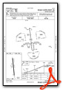
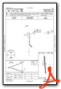
Instrument Approach Procedure (IAP) Charts
Nearby Airports with Instrument Procedures
| ID | Name | Heading / Distance | ||
|---|---|---|---|---|
 |
KCVB | Castroville Municipal Airport | 021° | 13.1 |
|
KHDO | South Texas Regional At Hondo Airport | 316° | 18.1 |
|
T30 | Mc Kinley Field Airport | 204° | 20.9 |
|
KSKF | Kelly Field Airport | 052° | 24.0 |
|
KPEZ | Pleasanton Municipal Airport | 116° | 24.8 |
|
KSSF | Stinson Municipal Airport | 064° | 27.4 |
|
KSAT | San Antonio International Airport | 046° | 34.3 |
|
5C1 | Boerne Stage Airfield Airport | 020° | 37.3 |
|
KRND | Randolph AFB Airport | 055° | 41.9 |
|
KUVA | Garner Field Airport | 276° | 42.3 |
|
KCOT | Cotulla-La Salle County Airport | 199° | 43.4 |
|
KERV | Kerrville Municipal/Louis Schreiner Field Airport | 351° | 50.7 |
Airport Images
Do you have a recent image of this airport? Upload it here!


