Login
Register


PEZ
Pleasanton Municipal Airport
Official FAA Data Effective 2026-02-19 0901Z
Chart Supplement

VFR Chart of KPEZ
Sectional Charts at SkyVector.com
IFR Chart of KPEZ
Enroute Charts at SkyVector.com
Location Information for KPEZ
Coordinates: N28°57.25' / W98°31.20'Located 03 miles W of Pleasanton, Texas on 94 acres of land. View all Airports in Texas.
Surveyed Elevation is 430 feet MSL.
Operations Data
|
|
Airport Communications
| AWOS-3: | 118.575 Tel. 830-569-5749 |
|---|---|
| SAN ANTONIO APPROACH: | 118.05 353.5 |
| SAN ANTONIO DEPARTURE: | 125.7 290.225 |
| CLEARANCE DELIVERY: | 121.375 |
| CTAF: | 122.700 |
| CRVZA RNAV STAR: | 125.7 290.225 |
| UNICOM: | 122.700 |
| POPPO RNAV STAR: | 125.1 |
| QERVO RNAV STAR: | 127.1 269.1 |
| POPPO RNV STAR: | 307.0 |
| DNKIN RNAV STAR: | 125.1 307.0 |
| ATIS at SSF (23.1 N): | 128.8 |
| ASOS at SSF (23.2 N): | 210-927-9391 |
| ATIS at SKF (26.0 N): | 120.45 |
Nearby Navigation Aids
|
| ||||||||||||||||||||||||||||||||||||||||||||||||||||||||||||


Runway 16/34
| Dimensions: | 4000 x 75 feet / 1219 x 23 meters | |
|---|---|---|
| Surface: | Asphalt in Good Condition | |
| Weight Limits: | S-4 | |
| Edge Lighting: | Medium Intensity | |
| Runway 16 | Runway 34 | |
| Coordinates: | N28°57.57' / W98°31.31' | N28°56.94' / W98°31.09' |
| Elevation: | 430.3 | 400.2 |
| Traffic Pattern: | Left | Left |
| Runway Heading: | 163° True | 343° True |
| Displaced Threshold: | 405 Feet | |
| Markings: | Non-Precision Instrument in good condition. | Non-Precision Instrument in good condition. |
| Glide Slope Indicator | P2L (4.00° Glide Path Angle) | P2L (3.00° Glide Path Angle) |
| Obstacles: | 16 ft Road 201 ft from runway, 250 ft right of center APCH SLOPE 0:1 AT DSPLCD THR OVR 8 FT FENCE AT DSPLCD THR 190 FT RIGHT. 8 FT FENCE, 36 FT DSTC, 220 FT L. |
8 ft Fence 201 ft from runway, 90 ft right of center 8 FT FENCE, 0-199 FT DSTC, R/L. |
Services Available
| Fuel: | 100LL (blue), Jet-A, Jet A+ |
|---|---|
| Transient Storage: | Hangars,Tiedowns |
| Airframe Repair: | NOT AVAILABLE |
| Engine Repair: | NOT AVAILABLE |
| Bottled Oxygen: | NONE |
| Bulk Oxygen: | NONE |
Ownership Information
| Ownership: | Publicly owned | |
|---|---|---|
| Owner: | CITY OF PLEASANTON | |
| BOX 209 | ||
| PLEASANTON, TX 78064 | ||
| 830-569-3867 | ||
| Manager: | JOHN ROBERTS | ASST UTILITIES SUPT. |
| PO BOX 209 | ||
| PLEASANTON, TX 78064 | ||
| 830-569-3155 | EXT 800 | |
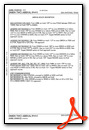
Other Remarks
- FOR CD IF UNA TO CTC VIA FREQ, CTC SAN ANTONIO APCH AT 210-805-5516.
- 0LL 100 LL AND JET A SELF SERVE. JET A AVBL FULL SERVE DURING ATTND HRS AND ON CALL AFTER HRS.
- DUSK-DAWN. MIRL RWY 16/34 PRESET LOW INTST; TO INCR INTST ACTVT - CTAF.
Weather Minimums


Standard Terminal Arrival (STAR) Charts
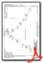
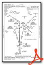


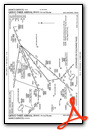
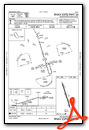
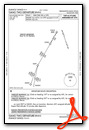
Instrument Approach Procedure (IAP) Charts
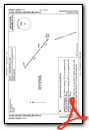
Departure Procedure (DP) Charts


Nearby Airports with Instrument Procedures
| ID | Name | Heading / Distance | ||
|---|---|---|---|---|
 |
KSSF | Stinson Municipal Airport | 006° | 23.1 |
|
23R | Devine Municipal Airport | 296° | 24.8 |
|
KSKF | Kelly Field Airport | 352° | 25.9 |
|
KCVB | Castroville Municipal Airport | 323° | 29.0 |
|
T30 | Mc Kinley Field Airport | 255° | 32.0 |
|
KSAT | San Antonio International Airport | 004° | 34.8 |
|
2R9 | Kenedy Regional Airport | 102° | 35.3 |
|
KRND | Randolph AFB Airport | 020° | 36.7 |
|
8T6 | Live Oak County Airport | 148° | 41.3 |
|
KHDO | South Texas Regional At Hondo Airport | 305° | 42.2 |
|
5C1 | Boerne Stage Airfield Airport | 348° | 46.9 |
|
KCOT | Cotulla-La Salle County Airport | 231° | 47.4 |
Airport Images
Do you have a recent image of this airport? Upload it here!


