Login
Register


27K
Georgetown-Scott County Regional Airport
Official FAA Data Effective 2026-01-22 0901Z
Chart Supplement

VFR Chart of 27K
Sectional Charts at SkyVector.com
IFR Chart of 27K
Enroute Charts at SkyVector.com
Location Information for 27K
Coordinates: N38°14.07' / W84°26.08'Located 06 miles E of Georgetown, Kentucky on 285 acres of land. View all Airports in Kentucky.
Surveyed Elevation is 947 feet MSL.
Operations Data
|
|
Airport Communications
| AWOS-3: | 119.975 Tel. 502-867-1564 |
|---|---|
| LEXINGTON APPROACH: | 120.15 ;040-220 120.75 ;221-039 259.3 ;040-220 298.9 ;221-039 |
| LEXINGTON DEPARTURE: | 120.15 ;040-220 120.75 ;221-039 259.3 ;040-220 298.9 ;221-039 |
| CLEARANCE DELIVERY: | 127.425 |
| CTAF: | 123.000 |
| UNICOM: | 123.000 |
| ATIS at LEX (14.4 SW): | 126.3 |
| ASOS at LEX (14.4 SW): | 859-203-5240 |
| ASOS at FFT (22.5 W): | 119.275 502-227-5087 |
Nearby Navigation Aids
|
| ||||||||||||||||||||||||||||||||||||||||||||||||||||||||||||


Runway 03/21
| Dimensions: | 5498 x 100 feet / 1676 x 30 meters | |
|---|---|---|
| Surface: | Asphalt in Good Condition | |
| Weight Limits: | 40 /F/C/X/T, S-102, D-143 | |
| Edge Lighting: | Medium Intensity | |
| Runway 03 | Runway 21 | |
| Coordinates: | N38°13.66' / W84°26.33' | N38°14.47' / W84°25.83' |
| Elevation: | 931.1 | 947.7 |
| Runway Heading: | 26° True | 206° True |
| Markings: | Non-Precision Instrument in fair condition. | Non-Precision Instrument in fair condition. |
| Glide Slope Indicator | P2L (3.00° Glide Path Angle) | P2L (3.00° Glide Path Angle) |
| REIL: | Yes | Yes |
Services Available
| Fuel: | 100LL (blue), Jet A+ |
|---|---|
| Transient Storage: | Hangars,Tiedowns |
| Airframe Repair: | NOT AVAILABLE |
| Engine Repair: | NOT AVAILABLE |
| Bottled Oxygen: | NOT AVAILABLE |
| Bulk Oxygen: | NOT AVAILABLE |
| Other Services: | CARGO HANDLING SERVICES,CHARTER SERVICE,PILOT INSTRUCTION,AIRCRAFT RENTAL |
Ownership Information
| Ownership: | Publicly owned | |
|---|---|---|
| Owner: | GEORGETOWN SCOTT COUNT AIRPORT CORP | |
| 6206 PARIS PIKE | ||
| GEORGETOWN, KY 40324 | ||
| 502-863-6320 | ||
| Manager: | JAMES TOOLE | |
| 6206 PARIS PIKE | ||
| GEORGETOWN, KY 40324 | ||
| 502-863-6320 | AFT HR - 859-608-8858. | |
Other Remarks
- FOR CD CTC LEXINGTON APCH AT 859-514-7890.
- 0LL FUEL AVBL 24/7 WITH CC.
- ACTVT REIL RWY 03/21; PAPI RWY 03/21; MIRL RWY 03/21; WINDSOCK - CTAF.
Weather Minimums

Instrument Approach Procedure (IAP) Charts

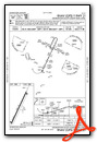
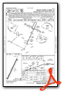
Nearby Airports with Instrument Procedures
| ID | Name | Heading / Distance | ||
|---|---|---|---|---|
 |
0I8 | Cynthiana-Harrison County Airport | 042° | 10.7 |
|
KLEX | Blue Grass Airport | 214° | 14.4 |
|
KFFT | Capital City Airport | 262° | 22.5 |
|
KIOB | Mount Sterling/Montgomery County Airport | 115° | 24.0 |
|
K62 | Gene Snyder Airport | 004° | 28.2 |
|
KRGA | Central Kentucky Regional Airport | 172° | 36.5 |
|
KFGX | Fleming-Mason Airport | 060° | 37.4 |
|
KSYM | Morehead-Rowan County Clyde A Thomas Regional Airport | 091° | 40.1 |
|
KDVK | Stuart Powell Field Airport | 202° | 42.5 |
|
KGEO | Brown County Airport | 033° | 46.7 |
|
KCVG | Cincinnati/Northern Kentucky International Airport | 347° | 50.0 |
|
I69 | Clermont County Airport | 011° | 51.7 |
Airport Images
Do you have a recent image of this airport? Upload it here!


