Login
Register


0I8
Cynthiana-Harrison County Airport
Official FAA Data Effective 2026-02-19 0901Z
Chart Supplement

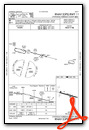
VFR Chart of 0I8
Sectional Charts at SkyVector.com
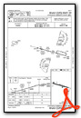
IFR Chart of 0I8
Enroute Charts at SkyVector.com
Location Information for 0I8
Coordinates: N38°21.97' / W84°17.00'Located 02 miles S of Cynthiana, Kentucky on 100 acres of land. View all Airports in Kentucky.
Surveyed Elevation is 720 feet MSL.
Operations Data
|
|
Airport Communications
| LEXINGTON APPROACH: | 120.15 ;040-220 120.75 ;221-039 259.3 ;040-220 298.9 ;221-039 |
|---|---|
| LEXINGTON DEPARTURE: | 120.15 ;040-220 120.75 ;221-039 259.3 ;040-220 298.9 ;221-039 |
| UNICOM: | 122.800 |
| CTAF: | 122.800 |
| AWOS-3 at 27K (10.4 SW): | 119.975 502-867-1564 |
| AWOS-3 at K62 (20.8 N): | 123.825 859-654-1345 |
| AWOS-3 at IOB (23.4 SE): | 120.675 859-498-7001 |
Nearby Navigation Aids
|
| ||||||||||||||||||||||||||||||||||||||||||||||||||||||||||||


Runway 11/29
| Dimensions: | 3850 x 75 feet / 1173 x 23 meters | |
|---|---|---|
| Surface: | Asphalt in Good Condition | |
| Weight Limits: | S-16, D-25 | |
| Edge Lighting: | Medium Intensity | |
| Runway 11 | Runway 29 | |
| Coordinates: | N38°22.05' / W84°17.39' | N38°21.88' / W84°16.61' |
| Elevation: | 720.9 | 720.0 |
| Traffic Pattern: | Left | Left |
| Runway Heading: | 106° True | 286° True |
| Displaced Threshold: | 1094 Feet | |
| Declared Distances: | TORA:2757 TODA:3852 ASDA:3852 LDA:3852 | TORA:3852 TODA:3852 ASDA:3852 LDA:2757 |
| Markings: | Non-Precision Instrument in fair condition. | Non-Precision Instrument in fair condition. |
| Glide Slope Indicator | P2L (4.00° Glide Path Angle) | P2L (4.00° Glide Path Angle) |
| REIL: | Yes | Yes |
| Obstacles: | 36 ft Railroad 716 ft from runway, 319 ft right of center | 55 ft Trees 5 ft from runway, 211 ft right of center APCH RATIO 19:1 TO DSPLCD THR. +55 FT TREES 5 FT FM RWY END 211 FT R OF CNTRLN. |
Services Available
| Fuel: | 100LL (blue) |
|---|---|
| Transient Storage: | Hangars,Tiedowns |
| Airframe Repair: | MINOR |
| Engine Repair: | MINOR |
| Bottled Oxygen: | NONE |
| Bulk Oxygen: | NONE |
| Other Services: | PILOT INSTRUCTION |
Ownership Information
| Ownership: | Publicly owned | |
|---|---|---|
| Owner: | CYNTHIANA-HARRISON COUNTY ARPT BD | |
| P.O. BOX 395 | ||
| CYNTHIANA, KY 41031 | ||
| 859-234-5533 | ||
| Manager: | ROBERT CRAFT | |
| 40 AIRFIELD LANE | ||
| CYNTHIANA, KY 41031 | ||
| 859-234-8477 | ||
Other Remarks
- FOR CD CTC LEXINGTON APCH AT 859-514-7890.
- 0LL FUEL AVBL 24/7 WITH CC.
- ACTVT REIL RWY 11 & 29; PAPI RWY 11 & 29; MIRL RWY 11/29 - CTAF.
Weather Minimums

Instrument Approach Procedure (IAP) Charts
Nearby Airports with Instrument Procedures
| ID | Name | Heading / Distance | ||
|---|---|---|---|---|
 |
27K | Georgetown-Scott County Regional Airport | 222° | 10.7 |
|
K62 | Gene Snyder Airport | 345° | 20.9 |
|
KIOB | Mount Sterling/Montgomery County Airport | 142° | 23.4 |
|
KLEX | Blue Grass Airport | 218° | 25.0 |
|
KFGX | Fleming-Mason Airport | 067° | 27.5 |
|
KFFT | Capital City Airport | 249° | 31.5 |
|
KSYM | Morehead-Rowan County Clyde A Thomas Regional Airport | 105° | 34.1 |
|
KGEO | Brown County Airport | 031° | 36.2 |
|
I69 | Clermont County Airport | 004° | 42.8 |
|
KRGA | Central Kentucky Regional Airport | 183° | 44.1 |
|
KAMT | Alexander Salamon Airport | 048° | 44.6 |
|
KLUK | Cincinnati Municipal/Lunken Field Airport | 351° | 44.6 |
Airport Images

By: 2flaps


Comments
By far the kindest people i
By far the kindest people i have ever met my entire life.
Beautiful scenario, Kind FBO , Cheap Gas and a classic kentucky county.
WE had an Engine problem so we had to stay the night there, the people did eerything they could to help us out including food, shower and where to sleep.
Truly an amazing place with people you dont meet everyday ( unfortunately )!
Thanx for Everything.
Wonderful Place To Stop
Recently stopped at Cynthiana for a fuel stop on a weekend during a long cross-country. This is a great little airport! The people are very kind and friendly. We had an issue with the pump, but one of the local airport board members was there to assist. The facilities are outstanding, nice pilot lounge with popcorn, ice cream, and drinks. Also, great fuel prices! Highly recommend Cynthiana and the great folks there. Thanks City of Cynthiana and the friendly and helpful people there!
Paul Pillar
PA-28-180: N4375T
Senior Flight Test Engineer/Test Conductor
FAA Safety Team (FAAST) Representative
Civil Air Patrol Oklahoma Wing Director of Aerospace Education (DAE)