Login
Register


2MT1
Ryan Field Airport
Official FAA Data Effective 2026-01-22 0901Z
VFR Chart of 2MT1
Sectional Charts at SkyVector.com
IFR Chart of 2MT1
Enroute Charts at SkyVector.com
Location Information for 2MT1
Coordinates: N48°28.98' / W113°57.57'Located 01 miles SE of West Glacier, Montana on 153 acres of land. View all Airports in Montana.
Estimated Elevation is 3660 feet MSL.
Operations Data
|
|
Airport Communications
| ASOS at GPI (15.7 SW): | 132.625 406-233-0175 |
|---|---|
| ATIS at GPI (15.7 SW): | 132.625 |
| AWOS-3 at 7S0 (55.3 S): | 119.925 406-676-2967 |
Nearby Navigation Aids
|
| ||||||||||||||||||||||||||||||


Runway 15/33
| Dimensions: | 2500 x 65 feet / 762 x 20 meters | |
|---|---|---|
| Surface: | Turf | |
| Runway 15 | Runway 33 | |
| Obstacles: | 60 ft Trees 0 ft from runway | 60 ft Trees 0 ft from runway |
Ownership Information
| Ownership: | Privately Owned | |
|---|---|---|
| Owner: | RECREATIONAL AVIATION FOUNDATION | |
| 1711 WEST COLLEGE ST. | ||
| BOZEMAN, MT 59715 | ||
| 406-582-1723 | ||
| Manager: | RECREATIONAL AVIATION FOUNDATION | |
| 1711 WEST COLLEGE ST. | ||
| BOZEMAN, MT 59715 | ||
| 406-582-1723 | ||
Other Remarks
- MUST OBTAIN MANDATORY SAFETY BRIEFING BEFORE LNDG AT 2MT1. OBTAIN AT WWW. THERAF.ORG
- FOR CD CTC SALT LAKE ARTCC AT 801-320-2568.
Nearby Airports with Instrument Procedures
| ID | Name | Heading / Distance | ||
|---|---|---|---|---|
 |
KGPI | Glacier Park International Airport | 228° | 15.7 |
|
8S1 | Polson Airport | 190° | 48.2 |
|
7S0 | Ronan Airport | 185° | 55.3 |
|
S59 | Libby Airport | 259° | 62.4 |
|
CZPC | Pincher Creek Airport | 358° | 62.3 |
|
KCTB | Cut Bank International Airport | 082° | 63.6 |
|
S01 | Conrad Airport | 102° | 81.6 |
|
KCII | Choteau Airport | 117° | 82.0 |
|
KSBX | Shelby Airport | 086° | 83.4 |
|
65S | Boundary County Airport | 279° | 94.1 |
|
KMSO | Missoula Montana Airport | 183° | 94.2 |
|
KSZT | Sandpoint Airport | 264° | 104.6 |
Airport Images

By: Big Orange Bird
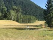
By: Big Orange Bird


