Login
Register


HEQ
Holyoke Airport
Official FAA Data Effective 2026-02-19 0901Z
Chart Supplement

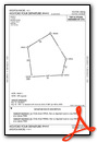
VFR Chart of KHEQ
Sectional Charts at SkyVector.com
IFR Chart of KHEQ
Enroute Charts at SkyVector.com
Location Information for KHEQ
Coordinates: N40°34.17' / W102°16.36'Located 01 miles SE of Holyoke, Colorado on 110 acres of land. View all Airports in Colorado.
Surveyed Elevation is 3729 feet MSL.
Operations Data
|
|
Airport Communications
| AWOS-3: | 119.275 Tel. 970-854-3679 |
|---|---|
| CTAF: | 122.700 |
| UNICOM: | 122.700 |
| AWOS-3 at 2V5 (28.2 S): | 118.250 970-332-5930 |
| ASOS at IML (30.0 E): | 124.175 308-882-5186 |
| AWOS-3PT at GGF (30.6 NE): | 118.025 308-352-4689 |
- APCH/DEP CTL SVC PRVDD BY DENVER ARTCC (ZDV) ON FREQS 118.475/225.4 (BRUSH/B/ RCAG).
Nearby Navigation Aids
|
| ||||||||||||||||||||||||||||||||||||||||||||||||||||||||||||


Runway 14/32
| Dimensions: | 5000 x 75 feet / 1524 x 23 meters | |
|---|---|---|
| Surface: | Asphalt in Good Condition | |
| Weight Limits: | S-12 | |
| Edge Lighting: | Medium Intensity | |
| Runway 14 | Runway 32 | |
| Coordinates: | N40°34.52' / W102°16.64' | N40°33.81' / W102°16.08' |
| Elevation: | 3729.5 | 3723.6 |
| Runway Heading: | 149° True | 329° True |
| Markings: | Non-Precision Instrument in fair condition. | Non-Precision Instrument in fair condition. |
| Glide Slope Indicator | P4L (3.00° Glide Path Angle) | P4L (3.00° Glide Path Angle) |
| REIL: | Yes | Yes |
Services Available
| Fuel: | 100LL (blue), Jet-A |
|---|---|
| Transient Storage: | Tiedowns |
| Airframe Repair: | NONE |
| Engine Repair: | NONE |
| Bottled Oxygen: | NONE |
| Bulk Oxygen: | NONE |
| Other Services: | CROP DUSTING SERVICES,PILOT INSTRUCTION |
Ownership Information
| Ownership: | Publicly owned | |
|---|---|---|
| Owner: | CITY OF HOLYOKE | |
| 407 E DENVER ST | ||
| HOLYOKE, CO 80734 | ||
| 970-854-2266 | AFT HRS CALL 970-854-2735. | |
| Manager: | JEREMY THOMPSON | JEREMY THOMPSON - CITY SUPERINTENDENT. |
| 407 E DENVER ST | ||
| HOLYOKE, CO 80734 | ||
| 970-854-2266 | ||
Other Remarks
- GEESE ON & INVOF RY.
- FOR CD CTC DENVER ARTCC AT 303-651-4257.
- 0LL FOR FUEL CALL 970-854-2266 DRG NML HRS OR 970-854-2735 AFT HRS.
- ACTVT REIL RWY 14 & 32; MIRL RWY 14/32 - CTAF. PAPI RWY 14 & 32 ON CONSLY.
Weather Minimums
Instrument Approach Procedure (IAP) Charts

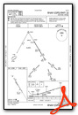
Departure Procedure (DP) Charts
Nearby Airports with Instrument Procedures
| ID | Name | Heading / Distance | ||
|---|---|---|---|---|
 |
2V5 | Wray Municipal Airport | 177° | 28.2 |
|
KIML | Imperial Municipal Airport | 096° | 30.1 |
|
KGGF | Grant Municipal Airport | 053° | 30.5 |
|
2V6 | Yuma Municipal Airport | 216° | 34.4 |
|
KOGA | Searle Field Airport | 034° | 40.2 |
|
KSTK | Sterling Municipal Airport | 273° | 45.4 |
|
KSNY | Sidney Municipal/Lloyd W Carr Field Airport | 314° | 45.4 |
|
KAKO | Colorado Plains Regional Airport | 241° | 49.5 |
|
KOKS | Garden County/King Rhiley Field Airport | 355° | 50.1 |
|
KSYF | Cheyenne County Municipal Airport | 155° | 53.3 |
|
KFMM | Fort Morgan Municipal Airport | 259° | 71.5 |
|
KADT | Atwood-Rawlins County City-County Airport | 127° | 71.5 |
Airport Images

By: brb

By: jbellwoo


Comments
Nice Runway and Fuel
Excellent runway and ramp. Close to town. Fuel available. No obvious pilot's facilities or FBO. Ag operations in season.