Login
Register


SPA
Spartanburg Downtown Memorial/Simpson Field Airport
Official FAA Data Effective 2025-11-27 0901Z
Chart Supplement

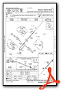
VFR Chart of KSPA
Sectional Charts at SkyVector.com
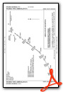
IFR Chart of KSPA
Enroute Charts at SkyVector.com
Location Information for KSPA
Coordinates: N34°54.98' / W81°57.35'Located 03 miles SW of Spartanburg, South Carolina on 544 acres of land. View all Airports in South Carolina.
Surveyed Elevation is 802 feet MSL.
TPA: 800 FT AGL FOR PISTON ACFT, 1300 FT AGL FOR TURBO PROP ACFT AND SML JETS.
Operations Data
|
|
Airport Communications
| AWOS-3: | 133.925 Tel. 864-587-2529 |
|---|---|
| GREER APPROACH: | 119.4 350.2 |
| GREER DEPARTURE: | 119.4 350.2 |
| CLEARANCE DELIVERY: | 120.55 |
| UNICOM: | 123.000 |
| BIMMR DP: | 119.4R 350.2 |
| BWALL DP: | 119.4 350.2 |
| CTAF: | 123.000 |
| ATIS at GSP (13.0 W): | 134.25 |
| ASOS at GSP (13.2 W): | 864-334-6232 |
| ASOS at GMU (19.8 W): | 127.075 864-239-0014 |
- APCH/DEP SVC PRVDD BY ATLANTA ARTCC ON FREQS 135.35/263.125 (OWING RCAG) WHEN GREER APCH CTL CLSD.
Nearby Navigation Aids
|
| ||||||||||||||||||||||||||||||||||||||||||||||||||||||||||||


Runway 05/23
| Dimensions: | 5852 x 100 feet / 1784 x 30 meters | |
|---|---|---|
| Surface: | Asphalt in Excellent Condition | |
| Weight Limits: | 37 /F/C/X/T, S-95, D-131 | |
| Edge Lighting: | High Intensity | |
| Runway 05 | Runway 23 | |
| Coordinates: | N34°54.62' / W81°57.73' | N34°55.35' / W81°56.96' |
| Elevation: | 794.5 | 786.5 |
| Traffic Pattern: | Left | Left |
| Runway Heading: | 42° True | 222° True |
| Declared Distances: | TORA:5852 TODA:5852 ASDA:5852 LDA:5852 | TORA:5852 TODA:5852 ASDA:5452 LDA:5452 |
| Markings: | Precision Instrument in good condition. | Precision Instrument in good condition. |
| Glide Slope Indicator | P4R (3.00° Glide Path Angle) | P4L (3.00° Glide Path Angle) |
| Approach Lights: | MALSR 1,400 Foot Medium-intensity Approach Lighting System with runway alignment indicator lights. | |
| REIL: | Yes | |
| Obstacles: | 88 ft Tree 3504 ft from runway, 117 ft right of center | |
Services Available
| Fuel: | 100LL (blue), Jet-A |
|---|---|
| Transient Storage: | Hangars,Tiedowns |
| Airframe Repair: | MAJOR |
| Engine Repair: | MAJOR |
| Bottled Oxygen: | NONE |
| Bulk Oxygen: | NONE |
| Other Services: | GLIDER SERVICE,PILOT INSTRUCTION,AIRCRAFT RENTAL |
Ownership Information
| Ownership: | Publicly owned | |
|---|---|---|
| Owner: | CITY OF SPARTANBURG | |
| PO DRAWER 1749 | ||
| SPARTANBURG, SC 29304 | ||
| 864-596-2000 | ||
| Manager: | TERRY CONNORTON | |
| 500 AMMONS RD | ||
| SPARTANBURG, SC 29306 | ||
| (864) 580-5004 | ||
Other Remarks
- GLIDER OPS.
- FOR CD IF UNA TO CTC ON FSS FREQ, CTC GREER APCH AT 864-877-8275, WHEN APCH CLSD CTC ATLANTA ARTCC AT 770-210-7692.
- 0LL FOR FUEL AFT HRS CALL 864-574-8552.
- ACTVT MALSR RWY 05; REIL RWY 23; PAPI RWY 05 & 23; HIRL RWY 05/23 - CTAF.
- TPA: 800 FT AGL FOR PISTON ACFT, 1300 FT AGL FOR TURBO PROP ACFT AND SML JETS.
Weather Minimums
Standard Terminal Arrival (STAR) Charts


Instrument Approach Procedure (IAP) Charts


Departure Procedure (DP) Charts


Nearby Airports with Instrument Procedures
| ID | Name | Heading / Distance | ||
|---|---|---|---|---|
 |
KGSP | Greenville Spartanburg International Airport | 264° | 13.0 |
|
KGMU | Greenville Downtown Airport | 258° | 19.9 |
|
35A | Union County, Troy Shelton Field Airport | 131° | 20.7 |
|
KGYH | Donaldson Field Airport | 245° | 22.8 |
|
KLUX | Laurens County Airport | 178° | 24.5 |
|
KEHO | Shelby-Cleveland County Regional Airport | 040° | 26.8 |
|
KFQD | Rutherford County/Marchman Field Airport | 001° | 30.7 |
|
KLQK | Pickens County Airport | 260° | 37.4 |
|
KDCM | Chester Catawba Regional Airport | 101° | 38.3 |
|
KEOE | Newberry County Airport | 156° | 39.6 |
|
KGRD | Greenwood County Airport | 194° | 41.1 |
|
KAVL | Asheville Regional Airport | 317° | 42.4 |
Airport Images
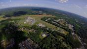
By: Matthias79
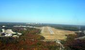
By: SPAflyer


