Login
Register


38I
Cook Airport
Official FAA Data Effective 2026-01-22 0901Z
Chart Supplement

VFR Chart of 38I
Sectional Charts at SkyVector.com
IFR Chart of 38I
Enroute Charts at SkyVector.com
Location Information for 38I
Coordinates: N40°5.47' / W83°41.36'Located 03 miles ESE of Urbana, Ohio on 5 acres of land. View all Airports in Ohio.
Estimated Elevation is 1150 feet MSL.
Operations Data
|
|
Airport Communications
| CTAF: | 123.000 |
|---|---|
| UNICOM: | 123.000 |
| AWOS-3 at I74 (3.9 NW): | 118.325 937-484-5863 |
| AWOS-3PT at UYF (14.1 SE): | 120.85 740-852-2844 |
| AWOS-3PT at SGH (16.9 SW): | 134.975 937-324-4532 |
Nearby Navigation Aids
|
| ||||||||||||||||||||||||||||||||||||||||||||||||||||||||||||


Runway 09/27
| Dimensions: | 2650 x 75 feet / 808 x 23 meters | |
|---|---|---|
| Surface: | Turf in Good Condition | |
| Runway 09 | Runway 27 | |
| Coordinates: | N40°5.45' / W83°41.64' | N40°5.49' / W83°41.08' |
| Elevation: | 1150.0 | 1150.0 |
| Traffic Pattern: | Left | Left |
| Obstacles: | 70 ft Trees 48 ft from runway, 67 ft right of center CTLG OBSTN EXCEEDS A 45 DEG SLP. |
10 ft Crops 60 ft from runway, 125 ft right of center |
Services Available
| Fuel: | NONE |
|---|---|
| Transient Storage: | Tiedowns FOR LCTN OF TIEDOWN AREAS CALL AMGR. |
| Airframe Repair: | NONE |
| Engine Repair: | NONE |
| Bottled Oxygen: | NONE |
| Bulk Oxygen: | NONE |
Ownership Information
| Ownership: | Privately Owned | |
|---|---|---|
| Owner: | CHRISTOPHER COOK | |
| 8761 WILDLANE DR | ||
| SOUTH CHARLESTON, OH 45368-7787 | ||
| 937-360-5308 | ||
| Manager: | CHRISTOPHER COOK | |
| 8761 WILDLANE DR | ARPT PHYS LCTN: JUST NORTH OF 3138 E STATE ROUTE 29, URBANA OH 43078. | |
| SOUTH CHARLESTON, OH 45368-7787 | ||
| 937-360-5308 | ||
Other Remarks
- FOR CD CTC COLUMBUS APCH AT 614-338-8537.
- RWY OUTLINED WITH YELLOW TIRES; RWY END MKD WITH YELLOW CONC PANELS.
- RWY OUTLINED WITH YELLOW TIRES; RWY END MKD WITH YELLOW CONC PANELS.
Nearby Airports with Instrument Procedures
| ID | Name | Heading / Distance | ||
|---|---|---|---|---|
 |
I74 | Grimes Field Airport | 309° | 3.9 |
|
KUYF | Madison County Airport | 132° | 14.1 |
|
KSGH | Springfield/Beckley Municipal Airport | 204° | 16.6 |
|
KMRT | Union County Airport | 062° | 17.5 |
|
KEDJ | Bellefontaine Regional Airport | 340° | 17.9 |
|
KFFO | Wright-Patterson AFB Airport | 226° | 22.9 |
|
KSCA | Sidney Municipal Airport | 293° | 22.9 |
|
KDAY | James M Cox Dayton International Airport | 245° | 26.9 |
|
KGDK | Greene County/Lewis A Jackson Regional Airport | 210° | 27.8 |
|
KTZR | Bolton Field Airport | 113° | 27.9 |
|
KOSU | Ohio State University Airport | 091° | 28.4 |
|
KDLZ | Delaware Municipal/Jim Moore Field Airport | 066° | 28.8 |
Airport Images
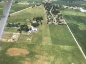
By: btracy62


