Login
Register


41N
Braceville Airport
Official FAA Data Effective 2026-01-22 0901Z
Chart Supplement

VFR Chart of 41N
Sectional Charts at SkyVector.com
IFR Chart of 41N
Enroute Charts at SkyVector.com
Location Information for 41N
Coordinates: N41°12.67' / W80°58.16'Located 02 miles N of Newton Falls, Ohio. View all Airports in Ohio.
Estimated Elevation is 900 feet MSL.
Operations Data
|
|
Airport Communications
| CTAF: | 122.800 |
|---|---|
| UNICOM: | 122.800 |
| AWOS-3 at POV (12.6 W): | 118.675 330-298-9353 |
| ATIS at YNG (13.4 E): | 123.75 |
| ASOS at YNG (13.6 E): | 330-856-9357 |
Nearby Navigation Aids
|
| ||||||||||||||||||||||||||||||||||||||||||||||||||||||||||||


Runway 01/19
| Dimensions: | 3000 x 30 feet / 914 x 9 meters | |
|---|---|---|
| Surface: | Asphalt in Poor Condition EXTSV CRACKING. | |
| Runway 01 | Runway 19 | |
| Traffic Pattern: | Left | Left |
| Displaced Threshold: | 55 Feet | |
| Markings: | Non-Standard in fair condition. | Non-Standard in fair condition. |
| Obstacles: | 17 ft Brush 201 ft from runway, 112 ft right of center OBST CLNC SLP 10:1 AT DTHR OVR 62 FT TREES, 680 FT DIST. 10 FT BRUSH IN DITCHLINE PARL TO RWY, FULL LEN, 85 FT R. |
92 ft Trees 423 ft from runway, 195 ft left of center |
Services Available
| Fuel: | NONE |
|---|---|
| Transient Storage: | NONE |
| Airframe Repair: | NONE |
| Engine Repair: | NONE |
| Bottled Oxygen: | NONE |
| Bulk Oxygen: | NONE |
Ownership Information
| Ownership: | Privately Owned | |
|---|---|---|
| Owner: | BRACEVILLE AIRPORT LLC | |
| 4720 STATE ROUTE 5 | ||
| NEWTON FALLS, OH 44444-9540 | ||
| 440-552-1082 | ||
| Manager: | DAN CLARKE | DAN41N@ATT.NET. |
| 4560 ZELLER RD | ||
| COLUMBUS, OH 43214-2553 | ||
| 440-552-1082 | ||
Other Remarks
- FOR CD CTC YOUNGSTOWN APCH AT 330-856-4806, WHEN APCH CLSD CTC CLEVELAND ARTCC AT 440-774-0223/0490.
- DEER, BIRDS, & WILDLIFE ON & INVOF ARPT.
- FADED.
- NSTD BASIC DUE TO SIZE & SPACING.
- FADED.
- NSTD BASIC DUE TO SIZE & SPACING.
Nearby Airports with Instrument Procedures
| ID | Name | Heading / Distance | ||
|---|---|---|---|---|
 |
KPOV | Portage County Airport | 269° | 12.8 |
|
KYNG | Youngstown/Warren Regional Airport | 076° | 13.4 |
|
7G8 | Geauga County Airport | 343° | 14.9 |
|
38D | Salem Airpark Airport | 162° | 16.5 |
|
3G6 | Tri-City Airport | 184° | 18.4 |
|
4G4 | Youngstown Elser Metro Airport | 138° | 20.0 |
|
1G3 | Kent State University Airport | 260° | 20.5 |
|
KAKR | Akron Fulton International Airport | 245° | 24.9 |
|
KUCP | New Castle Municipal Airport | 113° | 27.6 |
|
KCAK | Akron-Canton Regional Airport | 230° | 27.9 |
|
2G1 | Concord Airpark Airport | 339° | 29.2 |
|
4G1 | Greenville Municipal Airport | 061° | 29.7 |
Airport Images
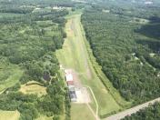
By: btracy62


