Login
Register


51D
Edgeley Municipal Airport
Official FAA Data Effective 2025-11-27 0901Z
Chart Supplement

VFR Chart of 51D
Sectional Charts at SkyVector.com
IFR Chart of 51D
Enroute Charts at SkyVector.com
Location Information for 51D
Coordinates: N46°20.98' / W98°44.10'Located 01 miles WSW of Edgeley, North Dakota on 210 acres of land. View all Airports in North Dakota.
Surveyed Elevation is 1603 feet MSL.
Operations Data
|
|
Airport Communications
| CTAF: | 122.800 |
|---|---|
| UNICOM: | 122.800 |
| AWOS-3 at 2D5 (29.2 E): | 118.675 701-742-3991 |
| ASOS at JMS (34.9 N): | 118.425 701-251-9002 |
| AWOS-3 at GWR (46.0 E): | 118.325 701-678-6801 |
- APCH/DEP SVC PRVDD BY MINNEAPOLIS ARTCC ON FREQS 124.2/270.3 (WOODWORTH RCAG).
Nearby Navigation Aids
|
| ||||||||||||||||||||||||||||||||||||||||||||||||


Runway 14/32
| Dimensions: | 3600 x 60 feet / 1097 x 18 meters | |
|---|---|---|
| Surface: | Asphalt in Good Condition | |
| Weight Limits: | S-12 | |
| Edge Lighting: | Medium Intensity | |
| Runway 14 | Runway 32 | |
| Coordinates: | N46°21.17' / W98°44.31' | N46°20.66' / W98°43.87' |
| Elevation: | 1600.8 | 1591.8 |
| Runway Heading: | 149° True | 329° True |
| Markings: | Non-Precision Instrument in good condition. | Non-Precision Instrument in good condition. |
| Glide Slope Indicator | P2L (3.00° Glide Path Angle) | |
Runway 09/27
| Dimensions: | 2800 x 116 feet / 853 x 35 meters | |
|---|---|---|
| Surface: | Turf in Good Condition | |
| Runway 09 | Runway 27 | |
| Coordinates: | N46°21.08' / W98°44.45' | N46°21.07' / W98°43.78' |
| Elevation: | 1603.5 | 1588.0 |
| Runway Heading: | 91° True | 271° True |
| Markings: | None | None |
Services Available
| Fuel: | 100LL (blue), Jet-A |
|---|---|
| Transient Storage: | Hangars,Tiedowns |
| Airframe Repair: | NONE |
| Engine Repair: | NONE |
| Bottled Oxygen: | NONE |
| Bulk Oxygen: | NONE |
| Other Services: | CROP DUSTING SERVICES,PILOT INSTRUCTION |
Ownership Information
| Ownership: | Publicly owned | |
|---|---|---|
| Owner: | EDGELEY MUNI ARPT AUTH | |
| PO BOX 293 | ||
| EDGELEY, ND 58433 | ||
| (701) 320-8740 | ||
| Manager: | DAVE LUX | |
| PO BOX 334, BOX 345 | ||
| EDGELEY, ND 58433 | ||
| (701) 320-8740 | ADDNL CONTACT CHAIRMAN JUSTIN FREDENBURG 701-709-0114. | |
Other Remarks
- SNOW REMOVAL IREG; CONFIRM WINTER CONDITIONS BEFORE USE. CALL 701-709-0114/701-320-8740 FOR UPDATES.
- DEER AND BIRDS ON & INV OF ARPT.
- FOR CD CTC MINNEAPOLIS ARTCC AT 651-463-5588.
- 0LL 100LL AND JET A FUEL AVBL SELF SVC WITH CREDIT CARD.
- ACTVT PAPI RWY 32; MIRL RWY 14/32 - CTAF.
Weather Minimums

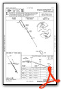
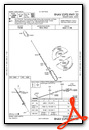
Instrument Approach Procedure (IAP) Charts
Nearby Airports with Instrument Procedures
| ID | Name | Heading / Distance | ||
|---|---|---|---|---|
 |
4E7 | Ellendale Municipal Airport | 155° | 22.0 |
|
2D5 | Oakes Municipal Airport | 110° | 29.2 |
|
KASY | Ashley Municipal Airport | 232° | 32.4 |
|
KJMS | Jamestown Regional Airport | 003° | 34.9 |
|
6L3 | Lisbon Municipal Airport | 081° | 42.2 |
|
KGWR | Gwinner/Roger Melroe Field Airport | 099° | 46.1 |
|
KBAC | Barnes County Municipal Airport | 039° | 46.3 |
|
KBTN | Britton Municipal Airport | 127° | 52.4 |
|
KABR | Aberdeen Regional Airport | 166° | 55.7 |
|
7L2 | Linton Municipal Airport | 263° | 63.3 |
|
46D | Carrington Municipal Airport | 345° | 68.3 |
|
S32 | Cooperstown Municipal Airport | 021° | 69.4 |
Airport Images
Do you have a recent image of this airport? Upload it here!


