Login
Register


5E9
Packer Airport
Official FAA Data Effective 2026-02-19 0901Z
Chart Supplement

VFR Chart of 5E9
Sectional Charts at SkyVector.com
IFR Chart of 5E9
Enroute Charts at SkyVector.com
Location Information for 5E9
Coordinates: N40°24.48' / W83°13.16'Located 03 miles NW of Radnor, Ohio on 15 acres of land. View all Airports in Ohio.
Estimated Elevation is 918 feet MSL.
Operations Data
|
|
Airport Communications
| CTAF: | 122.900 |
|---|---|
| AWOS-3 at DLZ (9.1 SE): | 119.025 740-203-1878 |
| AWOS-3 at MRT (12.5 SW): | 119.275 937-644-2967 |
| ASOS at MNN (14.3 NE): | 119.975 740-223-7502 |
Nearby Navigation Aids
|
| ||||||||||||||||||||||||||||||||||||||||||||||||||||||||||||


Runway 09/27
| Dimensions: | 3470 x 90 feet / 1058 x 27 meters | |
|---|---|---|
| Surface: | Turf in Excellent Condition | |
| Runway 09 | Runway 27 | |
| Displaced Threshold: | 120 Feet | |
| Obstacles: | RWY 27 0:1 DUE TO +75-84 TREES BEG AT THLD TO 200 FT DIST, 120 FT R. |
84 ft Trees 0 ft from runway, 120 ft right of center |
Services Available
| Fuel: | NONE |
|---|---|
| Transient Storage: | Tiedowns |
| Airframe Repair: | NONE |
| Engine Repair: | NONE |
| Bottled Oxygen: | NONE |
| Bulk Oxygen: | NONE |
Ownership Information
| Ownership: | Privately Owned | |
|---|---|---|
| Owner: | K5E9 LLC | |
| 5266 MOONEY RD | ||
| RADNOR, OH 43066-9710 | ||
| 740-494-2554 | ||
| Manager: | LINDA SUE PACKER | |
| 5266 MOONEY RD | ||
| RADNOR, OH 43066-9710 | ||
| 740-494-2554 | ||
Other Remarks
- FOR CD CTC COLUMBUS APCH AT 614-338-8537.
- DEER & BIRDS ON & INVOF ARPT.
- RWY 09/27 MARKED BY ORANGE TRAFFIC CONES.
Nearby Airports with Instrument Procedures
| ID | Name | Heading / Distance | ||
|---|---|---|---|---|
 |
KDLZ | Delaware Municipal/Jim Moore Field Airport | 147° | 9.1 |
|
KMRT | Union County Airport | 208° | 12.6 |
|
KMNN | Marion Municipal Airport | 029° | 14.4 |
|
4I9 | Morrow County Airport | 067° | 18.3 |
|
KOSU | Ohio State University Airport | 161° | 20.8 |
|
I95 | Hardin County Airport | 302° | 22.9 |
|
17G | Port Bucyrus/Crawford County Airport | 026° | 25.0 |
|
KEDJ | Bellefontaine Regional Airport | 265° | 27.6 |
|
56D | Wyandot County Airport | 351° | 28.8 |
|
KCMH | John Glenn Columbus International Airport | 148° | 28.9 |
|
I74 | Grimes Field Airport | 236° | 29.6 |
|
KUYF | Madison County Airport | 201° | 30.6 |
Airport Images
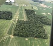
By: btracy62


