Login
Register


66G
Wm 'Tiny' Zehnder Field Airport
Official FAA Data Effective 2026-01-22 0901Z
Chart Supplement

VFR Chart of 66G
Sectional Charts at SkyVector.com
IFR Chart of 66G
Enroute Charts at SkyVector.com
Location Information for 66G
Coordinates: N43°18.86' / W83°42.60'Located 02 miles SE of Frankenmuth, Michigan on 20 acres of land. View all Airports in Michigan.
Estimated Elevation is 639 feet MSL.
Operations Data
|
|
Airport Communications
| CTAF: | 122.900 |
|---|---|
| AWOS-3PT at HYX (9.8 NW): | 118.325 989-752-3408 |
| AWOS-3 at CFS (14.4 NE): | 119.275 989-672-4182 |
| ATIS at MBS (20.8 NW): | 125.925 |
Nearby Navigation Aids
|
| ||||||||||||||||||||||||||||||||||||||||||||||||||||||||||||


Runway 09/27
| Dimensions: | 2500 x 100 feet / 762 x 30 meters | |
|---|---|---|
| Surface: | Turf in Good Condition SOFT IN SPRING & AFT HVY RAIN. | |
| Runway 09 | Runway 27 | |
| Coordinates: | N43°18.86' / W83°42.89' | N43°18.86' / W83°42.32' |
| Elevation: | 631.0 | 639.0 |
| Traffic Pattern: | Left | Left |
| Runway Heading: | 90° True | 270° True |
| Displaced Threshold: | 394 Feet | |
| Obstacles: | 18 ft Road 0 ft from runway, 100 ft right of center APCH RATIO 10:1 TO DTHR OVR +67 FT TREE, 670 FT DIST, 105 FT R. |
|
Services Available
| Fuel: | NONE |
|---|---|
| Transient Storage: | Tiedowns |
| Airframe Repair: | NONE |
| Engine Repair: | NONE |
| Bottled Oxygen: | NONE |
| Bulk Oxygen: | NONE |
| Other Services: | PILOT INSTRUCTION |
Ownership Information
| Ownership: | Privately Owned | |
|---|---|---|
| Owner: | FRANKENMUTH AIRPORT, INC | |
| PO BOX 15 | ||
| FRANKENMUTH, MI 48734-0015 | ||
| 989-652-7797 | ||
| Manager: | RUSSELL LOMBARDO | |
| PO BOX 15 | ||
| FRANKENMUTH, MI 48734-0015 | ||
| 810-614-4826 | ||
Other Remarks
- NO SNOW REMOVAL - CTC AMGR TO VFY FICON.
- RWY 09 -7 FT DITCH, 60 FT FM THR.
- RWY 27 +8 FT SEASONAL CROPS, 10 FT FM THR, 100 FT LEFT & RIGHT OF CNTRLN.
- FOR CD CTC GREAT LAKES APCH AT 269-459-3345, WHEN APCH CLSD CTC CLEVELAND ARTCC AT 440-774-0224/0490.
- DEER & LRG BIRDS ON & INVOF ARPT.
- RWY & DTHR MKD WITH 3 FT YELLOW CONES.
- 3 FT YELLOW CONES.
Nearby Airports with Instrument Procedures
| ID | Name | Heading / Distance | ||
|---|---|---|---|---|
 |
KHYX | Saginaw County/H W Browne Airport | 317° | 9.8 |
|
KCFS | Tuscola Area Airport | 053° | 14.5 |
|
3CM | James Clements Municipal Airport | 329° | 16.1 |
|
KMBS | Mbs International Airport | 309° | 20.8 |
|
KFNT | Bishop International Airport | 184° | 21.0 |
|
D95 | Dupont/Lapeer Airport | 127° | 24.3 |
|
KRNP | Owosso Community Airport | 224° | 26.9 |
|
77G | Marlette Township Airport | 090° | 27.1 |
|
9G2 | Prices Airport | 184° | 30.5 |
|
KIKW | Jack Barstow Airport | 311° | 31.9 |
|
Y83 | Sandusky City Airport | 077° | 38.9 |
|
KPTK | Oakland County International Airport | 161° | 40.9 |
Airport Images
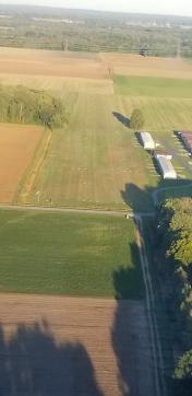
By: 15zenderb

By: sunmanav8


Comments
Looking for a hanger
I am looking for a Hanger to purchase, We own a home in Frankenmuth, rented space at Livingston County when we lived in Howell. Please reply if you may know someone ready to vacate. They can even leave a plane, I sold my 172 and ready to get back in the air.