Login
Register


6TN1
Weakleys Field Airport
Official FAA Data Effective 2025-12-25 0901Z
VFR Chart of 6TN1
Sectional Charts at SkyVector.com
IFR Chart of 6TN1
Enroute Charts at SkyVector.com
Location Information for 6TN1
Coordinates: N36°24.32' / W87°4.93'Located 02 miles W of Pleasantview, Tennessee on 4 acres of land. View all Airports in Tennessee.
Estimated Elevation is 705 feet MSL.
Operations Data
|
|
Airport Communications
| AWOS-3 at M91 (11.1 NE): | 120.675 615-656-5333 |
|---|---|
| AWOS-3 at JWN (16.3 SE): | 615-350-6222 |
| ATIS at JWN (16.4 SE): | 127.075 |
Nearby Navigation Aids
|
| ||||||||||||||||||||||||||||||||||||||||||||||||||||||||||||


Runway 18/36
| Dimensions: | 3370 x 60 feet / 1027 x 18 meters | |
|---|---|---|
| Surface: | Turf | |
| Runway 18 | Runway 36 | |
| Displaced Threshold: | 300 Feet | |
| Markings: | Non-Standard | |
| Obstacles: | 15 ft Road 20 ft from runway | |
Ownership Information
| Ownership: | Privately Owned | |
|---|---|---|
| Owner: | WEAKLEY'S FIELD, INC. | |
| 1255 OAKLAWN ROAD | ||
| CHAPMANSBORO, TN 37035 | ||
| 615-746-5236 | ||
| Manager: | BYRON WEAKLEY | |
| 1255 OAKLAWN ROAD | ||
| CHAPMANSBORO, TN 37035 | ||
| 615-218-3316 | ||
Other Remarks
- FOR CD CTC NASHVILLE APCH AT 615-695-4522.
- MKD WITH WHITE REFLECTORS EVERY 200 FT.
Nearby Airports with Instrument Procedures
| ID | Name | Heading / Distance | ||
|---|---|---|---|---|
 |
M91 | Springfield Robertson County Airport | 044° | 11.1 |
|
KJWN | John C Tune Airport | 144° | 16.4 |
|
KCKV | Outlaw Field Airport | 308° | 20.7 |
|
M02 | Dickson Municipal Airport | 225° | 23.7 |
|
KHOP | Campbell AAF (Fort Campbell) Airport | 309° | 25.5 |
|
KBNA | Nashville International Airport | 130° | 25.8 |
|
4M7 | Russellville-Logan County Airport | 028° | 27.0 |
|
1M5 | Douglas Hunter Field Airport | 068° | 31.4 |
|
KHVC | Hopkinsville-Christian County Airport | 326° | 32.5 |
|
KXNX | Music City Exec Airport | 092° | 32.7 |
|
KMQY | Smyrna Airport | 130° | 36.2 |
|
0M5 | Humphreys County Airport | 241° | 36.2 |
Airport Images
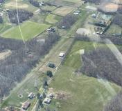
By: Big Orange Bird


