Login
Register


BFF
Scottsbluff/Western Nebraska Regional/Wm B Heilig Field Airport
Official FAA Data Effective 2025-11-27 0901Z
Chart Supplement

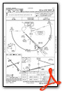
KBFF Airport Diagram

VFR Chart of KBFF
Sectional Charts at SkyVector.com
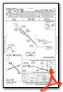
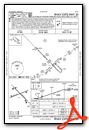
IFR Chart of KBFF
Enroute Charts at SkyVector.com
Location Information for KBFF
Coordinates: N41°52.44' / W103°35.74'Located 03 miles E of Scottsbluff, Nebraska on 1806 acres of land. View all Airports in Nebraska.
Surveyed Elevation is 3967 feet MSL.
Operations Data
|
|
Airport Communications
| ASOS: | 121.025 Tel. 308-281-6014 |
|---|---|
| CTAF: | 123.000 |
| UNICOM: | 123.000 |
| ASOS at TOR (27.4 NW): | 118.375 307-532-8958 |
| ASOS at AIA (37.0 E): | 135.075 308-762-1221 |
| AWOS-3 at IBM (41.3 S): | 118.075 308-235-2516 |
- APCH/DEP CTL SVC PRVDD BY DENVER ARTCC (ZDV) ON FREQS 127.95/338.2 (CRAWFORD RCAG).
Nearby Navigation Aids
|
| ||||||||||||||||||||||||||||||||||||||||||||||||||||||||||||


Runway 12/30
| Dimensions: | 8279 x 150 feet / 2523 x 46 meters | |
|---|---|---|
| Surface: | Asphalt in Good Condition | |
| Weight Limits: | S-109, D-178, ST-321
PCR VALUE: 2472/F/C/X/T
| |
| Edge Lighting: | High Intensity | |
| Runway 12 | Runway 30 | |
| Coordinates: | N41°52.94' / W103°36.30' | N41°51.96' / W103°35.02' |
| Elevation: | 3961.8 | 3944.1 |
| Traffic Pattern: | Left | Left |
| Runway Heading: | 136° True | 316° True |
| Declared Distances: | TORA:8279 TODA:8279 ASDA:8279 LDA:8279 | TORA:8279 TODA:8279 ASDA:8279 LDA:8279 |
| Markings: | Precision Instrument in good condition. | Precision Instrument in good condition. |
| Glide Slope Indicator | P4L (3.00° Glide Path Angle) | P4L (3.00° Glide Path Angle) |
| Approach Lights: | MALSR 1,400 Foot Medium-intensity Approach Lighting System with runway alignment indicator lights. | MALSR 1,400 Foot Medium-intensity Approach Lighting System with runway alignment indicator lights. |
Runway 05/23
| Dimensions: | 8002 x 150 feet / 2439 x 46 meters | |
|---|---|---|
| Surface: | Asphalt in Good Condition | |
| Weight Limits: | S-98, D-158, ST-285
PCR VALUE: 2472/F/C/X/T
| |
| Edge Lighting: | Medium Intensity | |
| Runway 05 | Runway 23 | |
| Coordinates: | N41°52.19' / W103°36.64' | N41°52.68' / W103°35.00' |
| Elevation: | 3949.2 | 3967.3 |
| Traffic Pattern: | Left | Left |
| Runway Heading: | 68° True | 248° True |
| Declared Distances: | TORA:8002 TODA:8002 ASDA:8002 LDA:8002 | TORA:8002 TODA:8002 ASDA:8002 LDA:8002 |
| Markings: | Non-Precision Instrument in good condition. | Non-Precision Instrument in good condition. |
| Glide Slope Indicator | V4L (3.00° Glide Path Angle) | P4L (3.00° Glide Path Angle) |
| Obstacles: | 31 ft Road 1650 ft from runway | |
Services Available
| Fuel: | 100LL (blue), Jet-A |
|---|---|
| Transient Storage: | Hangars,Tiedowns |
| Airframe Repair: | MAJOR |
| Engine Repair: | MAJOR |
| Bottled Oxygen: | NONE |
| Bulk Oxygen: | LOW |
| Other Services: | AIR FREIGHT SERVICES,CROP DUSTING SERVICES,CHARTER SERVICE,GLIDER SERVICE,PILOT INSTRUCTION,AIRCRAFT SALES,ANNUAL SURVEYING,GLIDER TOWING SERVICES |
Ownership Information
| Ownership: | Publicly owned | |
|---|---|---|
| Owner: | AIRPORT AUTHORITY OF SCOTTSBLUFF CO | |
| 250023 AIRPORT TERMINAL ST., SUITE 10 | ||
| SCOTTSBLUFF, NE 69361 | ||
| 308-635-4941 | ||
| Manager: | RAUL AGUALLO | |
| 250023 AIRPORT TERMINAL ST., SUITE 10 | ||
| SCOTTSBLUFF, NE 69361 | ||
| (308) 631-7449 | CELL PHONE 308-631-8098 OR 308-631-1591. | |
Other Remarks
- RY 30 DESIGNATED CALM WIND RY.
- WATERFOWL ON & INVOF ARPT.
- LINE OF SITE RESTRICTIONS BTWN APCH ENDS OF RYS 05 & 30 & ALSO BTWN THE APCH ENDS OF RYS 12 & 23.
- APRON PAVEMENT STRENGTH, S-85, D-117, DT-232. PCN IS 31/R/A/W/T.
- AC AND DC GROUND POWER UNITS AVAILABLE
- LAVATORY SERVICE AVAILABLE
- FOR CD CTC DENVER ARTCC ON FREQ. IF UNA, CTC FSS ON FREQ VIA RCO. IF UNA, CTC DENVER ARTCC AT 303-651-4257.
- ACTVT MIRL RY 05/23; HIRL RY 12/30; MALSR RYS 12 & 30 & VASI RY 05 & PAPI RYS 12 , 23 AND 30 - CTAF.
- PER AMGR USE CTAF WHEN OPERATING ON THE ARPT.
Weather Minimums


Instrument Approach Procedure (IAP) Charts


Nearby Airports with Instrument Procedures
| ID | Name | Heading / Distance | ||
|---|---|---|---|---|
 |
KTOR | Torrington Municipal Airport | 294° | 27.4 |
|
KAIA | Alliance Municipal Airport | 072° | 37.0 |
|
KIBM | Kimball Municipal/Robert E Arraj Field Airport | 185° | 41.3 |
|
82V | Pine Bluffs Municipal Airport | 209° | 49.6 |
|
KSNY | Sidney Municipal/Lloyd W Carr Field Airport | 149° | 54.0 |
|
KGUR | Camp Guernsey Airport | 294° | 55.7 |
|
KEAN | Phifer Airfield Airport | 280° | 60.6 |
|
KCDR | Chadron Municipal Airport | 020° | 61.9 |
|
KOKS | Garden County/King Rhiley Field Airport | 116° | 62.5 |
|
KCYS | Cheyenne Regional/Jerry Olson Field Airport | 232° | 69.7 |
|
9V5 | Modisett Airport | 044° | 72.8 |
|
KSTK | Sterling Municipal Airport | 168° | 77.0 |
Fuel Providers

Airport Images
Do you have a recent image of this airport? Upload it here!


