Login
Register


TOR
Torrington Municipal Airport
Official FAA Data Effective 2026-01-22 0901Z
Chart Supplement

VFR Chart of KTOR
Sectional Charts at SkyVector.com
IFR Chart of KTOR
Enroute Charts at SkyVector.com
Location Information for KTOR
Coordinates: N42°3.87' / W104°9.16'Located 02 miles E of Torrington, Wyoming on 517 acres of land. View all Airports in Wyoming.
Surveyed Elevation is 4206 feet MSL.
Operations Data
|
|
Airport Communications
| ASOS: | 118.375 Tel. 307-532-8958 |
|---|---|
| CTAF: | 122.800 |
| UNICOM: | 122.800 |
| ASOS at BFF (27.4 SE): | 121.025 308-281-6014 |
| ATIS at GUR (28.2 NW): | 119.825 |
| AWOS-3PT at EAN (35.0 W): | 121.125 307-322-1557 |
- APCH/DEP CTL SVC PRVDD BY DENVER ARTCC (ZDV) ON FREQS 127.95/338.2 (CRAWFORD RCAG).
Nearby Navigation Aids
|
| ||||||||||||||||||||||||||||||||||||||||||||||||||||||||||||


Runway 10/28
| Dimensions: | 5703 x 75 feet / 1738 x 23 meters | |
|---|---|---|
| Surface: | Asphalt in Good Condition | |
| Weight Limits: | 9 /F/B/X/T, S-33, D-45 | |
| Edge Lighting: | Medium Intensity | |
| Runway 10 | Runway 28 | |
| Coordinates: | N42°4.03' / W104°9.84' | N42°3.63' / W104°8.70' |
| Elevation: | 4204.8 | 4196.5 |
| Traffic Pattern: | Left | Left |
| Runway Heading: | 115° True | 295° True |
| Markings: | Non-Precision Instrument in good condition. | Non-Precision Instrument in good condition. |
| Glide Slope Indicator | P2L (3.00° Glide Path Angle) | P2L (3.00° Glide Path Angle) |
| REIL: | Yes | |
| Obstacles: | 13 ft Hill 666 ft from runway, 53 ft right of center | |
Runway 02/20
| Dimensions: | 3401 x 60 feet / 1037 x 18 meters | |
|---|---|---|
| Surface: | Asphalt in Good Condition | |
| Runway 02 | Runway 20 | |
| Coordinates: | N42°3.68' / W104°9.16' | N42°4.17' / W104°8.80' |
| Elevation: | 4197.5 | 4194.7 |
| Traffic Pattern: | Right | |
| Runway Heading: | 29° True | 209° True |
| Markings: | Basic in good condition. | Basic in good condition. |
Services Available
| Fuel: | 100LL (blue), Jet A+ |
|---|---|
| Transient Storage: | Hangars,Tiedowns |
| Airframe Repair: | MAJOR |
| Engine Repair: | NONE |
| Bottled Oxygen: | NONE |
| Bulk Oxygen: | NONE |
| Other Services: | CROP DUSTING SERVICES,PILOT INSTRUCTION |
Ownership Information
| Ownership: | Publicly owned | |
|---|---|---|
| Owner: | CITY OF TORRINGTON | |
| PO BOX 250 | ||
| TORRINGTON, WY 82240 | ||
| 307-532-5666 | ||
| Manager: | MIKE RICHEY | |
| 2000 E 20TH AVE. | ||
| TORRINGTON, WY 82240 | ||
| 307-532-8551 | ||
Other Remarks
- DEER & WATERFOWL ON & INVOF ARPT.
- FOR CD CTC DENVER ARTCC AT 303-651-4257.
- 0LL FOR FUEL AFT HRS CALL 307-338-8835.
- ACTVT REIL RWY 28; PAPI RWY 10 & 28; MIRL RWY 10/28 - CTAF.
Weather Minimums

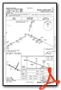
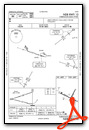
Instrument Approach Procedure (IAP) Charts


Nearby Airports with Instrument Procedures
| ID | Name | Heading / Distance | ||
|---|---|---|---|---|
 |
KBFF | Scottsbluff/Western Nebraska Regional/Wm B Heilig Field Airport | 114° | 27.4 |
|
KGUR | Camp Guernsey Airport | 294° | 28.2 |
|
KEAN | Phifer Airfield Airport | 269° | 34.7 |
|
82V | Pine Bluffs Municipal Airport | 179° | 54.7 |
|
KIBM | Kimball Municipal/Robert E Arraj Field Airport | 157° | 56.7 |
|
KAIA | Alliance Municipal Airport | 090° | 60.3 |
|
KCYS | Cheyenne Regional/Jerry Olson Field Airport | 208° | 62.0 |
|
KCDR | Chadron Municipal Airport | 045° | 66.0 |
|
KDGW | Converse County Airport | 309° | 70.2 |
|
KSNY | Sidney Municipal/Lloyd W Carr Field Airport | 137° | 78.2 |
|
KLAR | Laramie Regional Airport | 237° | 82.0 |
|
KHSR | Hot Springs Municipal Airport | 023° | 85.2 |
Airport Images
Do you have a recent image of this airport? Upload it here!


