Login
Register


8GK
Gallatin County Airport
Official FAA Data Effective 2026-01-22 0901Z
Chart Supplement

VFR Chart of 8GK
Sectional Charts at SkyVector.com
IFR Chart of 8GK
Enroute Charts at SkyVector.com
Location Information for 8GK
Coordinates: N38°40.77' / W84°55.73'Located 01 miles N of Sparta, Kentucky. View all Airports in Kentucky.
Surveyed Elevation is 830 feet MSL.
Operations Data
|
|
Airport Communications
| AWOS-3P: | 119.15 |
|---|---|
| CTAF: | 122.900 |
| ASOS at CVG (25.0 NE): | 134.375 859-414-0353 |
| AWOS-3 at K62 (25.0 E): | 123.825 859-654-1345 |
| D-ATIS at CVG (25.3 NE): | 135.3 ;DEP |
Nearby Navigation Aids
|
| ||||||||||||||||||||||||||||||||||||||||||||||||||||||||||||


Runway 06/24
| Dimensions: | 5000 x 75 feet / 1524 x 23 meters | |
|---|---|---|
| Surface: | Concrete in Good Condition | |
| Runway 06 | Runway 24 | |
| Coordinates: | N38°40.54' / W84°56.17' | N38°41.00' / W84°55.30' |
| Elevation: | 830.4 | 815.5 |
| Markings: | Non-Precision Instrument in good condition. | Non-Precision Instrument in good condition. |
| REIL: | Yes | Yes |
Ownership Information
| Ownership: | Publicly owned | |
|---|---|---|
| Owner: | GALLATIN COUNTY | |
| PO BOX 144 | ||
| WARSAW, KY 41095 | ||
| 859-567-5691 | ||
| Manager: | JON MORRIS | |
| PO BOX 144 | ||
| WARSAW, KY 41095 | ||
| 859-567-5691 | ||
Nearby Airports with Instrument Procedures
| ID | Name | Heading / Distance | ||
|---|---|---|---|---|
 |
K62 | Gene Snyder Airport | 086° | 25.3 |
|
KCVG | Cincinnati/Northern Kentucky International Airport | 028° | 25.3 |
|
KIMS | Madison Regional Airport | 281° | 25.6 |
|
KFFT | Capital City Airport | 177° | 29.9 |
|
KLUK | Cincinnati Municipal/Lunken Field Airport | 043° | 34.9 |
|
27K | Georgetown-Scott County Regional Airport | 138° | 35.4 |
|
I67 | Cincinnati West Airport | 011° | 35.5 |
|
0I8 | Cynthiana-Harrison County Airport | 121° | 35.7 |
|
KOVO | North Vernon Airport | 304° | 38.6 |
|
I69 | Clermont County Airport | 054° | 41.3 |
|
KLEX | Blue Grass Airport | 158° | 41.4 |
|
KJVY | Clark Regional Airport | 244° | 42.5 |
Airport Images
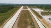
By: Wayne Rassman

By: Wayne Rassman


