Login
Register
AIA
Alliance Municipal Airport
Official FAA Data Effective 2026-01-22 0901Z
VFR Chart of KAIA
Sectional Charts at SkyVector.com
IFR Chart of KAIA
Enroute Charts at SkyVector.com
Location Information for KAIA
Coordinates: N42°3.19' / W102°48.22'Located 03 miles SE of Alliance, Nebraska on 3500 acres of land. View all Airports in Nebraska.
Surveyed Elevation is 3930 feet MSL.
Operations Data
|
|
Airport Communications
| ASOS: | 135.075 Tel. 308-762-1221 |
|---|---|
| CTAF: | 123.000 |
| UNICOM: | 123.000 |
| ASOS at BFF (37.0 W): | 121.025 308-281-6014 |
| ASOS at CDR (48.8 N): | 118.05 308-432-5574 |
| AWOS-3PT at GRN (52.9 NE): | 118.2 308-282-0127 |
- APCH/DEP CTL SVC PRVDD BY DENVER ARTCC (ZDV) ON FREQS 127.95/338.2 (CRAWFORD RCAG).
Nearby Navigation Aids
|
| ||||||||||||||||||||||||||||||||||||||||||||||||||||||||||||
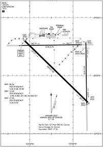
Runway 12/30
| Dimensions: | 9203 x 150 feet / 2805 x 46 meters | |
|---|---|---|
| Surface: | Asphalt / Aggregate Friction Seal Coated in Excellent Condition | |
| Weight Limits: | S-98, D-285, ST-158, DT-321
PCR VALUE: 39/R/B/W/T
| |
| Edge Lighting: | Medium Intensity | |
| Runway 12 | Runway 30 | |
| Coordinates: | N42°3.60' / W102°49.12' | N42°2.54' / W102°47.66' |
| Elevation: | 3929.8 | 3924.5 |
| Traffic Pattern: | Left | Left |
| Runway Heading: | 134° True | 314° True |
| Declared Distances: | TORA:9203 TODA:9203 ASDA:9203 LDA:9203 | TORA:9203 TODA:9203 ASDA:9203 LDA:9203 |
| Markings: | Non-Precision Instrument in good condition. | Precision Instrument in good condition. |
| Glide Slope Indicator | V4L (3.00° Glide Path Angle) | P4L (3.00° Glide Path Angle) |
| Approach Lights: | MALSR 1,400 Foot Medium-intensity Approach Lighting System with runway alignment indicator lights. | |
| REIL: | Yes | |
Runway 17/35
RWY 17/35 NOT AVBL FOR PART 121/PART 380 OPS WITH SKED PAX CARRYING OPS MORE THAN 9 PAX SEATS AND NON-SKED PAX CARRYING OPS MORE THAN 30 PAX SEATS. | ||
| Dimensions: | 6311 x 75 feet / 1924 x 23 meters | |
|---|---|---|
| Surface: | Asphalt in Poor Condition | |
| Weight Limits: | S-24, D-30
PCR VALUE: 39/R/B/W/T
| |
| Runway 17 | Runway 35 | |
| Coordinates: | N42°3.56' / W102°47.71' | N42°2.53' / W102°47.69' |
| Elevation: | 3924.6 | 3925.2 |
| Traffic Pattern: | Left | Left |
| Runway Heading: | 179° True | 359° True |
| Declared Distances: | TORA:6311 TODA:6311 ASDA:6311 LDA:6311 | TORA:6311 TODA:6311 ASDA:6311 LDA:6311 |
| Markings: | Basic in fair condition. | Basic in fair condition. |
Runway 08/26
| Dimensions: | 6190 x 75 feet / 1887 x 23 meters | |
|---|---|---|
| Surface: | Asphalt / Porous Friction Course in Good Condition | |
| Weight Limits: | S-36, D-48, ST-80
PCR VALUE: 39/R/B/W/T
| |
| Edge Lighting: | Medium Intensity | |
| Runway 08 | Runway 26 | |
| Coordinates: | N42°3.52' / W102°49.21' | N42°3.53' / W102°47.84' |
| Elevation: | 3930.6 | 3924.9 |
| Traffic Pattern: | Left | Left |
| Runway Heading: | 89° True | 269° True |
| Declared Distances: | TORA:6190 TODA:6190 ASDA:6190 LDA:6190 | TORA:6190 TODA:6190 ASDA:6190 LDA:6190 |
| Markings: | Non-Precision Instrument in good condition. | Non-Precision Instrument in good condition. |
Services Available
| Fuel: | 100LL (blue), Jet-A |
|---|---|
| Transient Storage: | Hangars,Tiedowns |
| Airframe Repair: | MAJOR |
| Engine Repair: | MAJOR |
| Bottled Oxygen: | NONE |
| Bulk Oxygen: | NOT AVAILABLE |
| Other Services: | CROP DUSTING SERVICES,PILOT INSTRUCTION,AIRCRAFT RENTAL,AIRCRAFT SALES |
Ownership Information
| Ownership: | Publicly owned | |
|---|---|---|
| Owner: | CITY OF ALLIANCE | |
| PO BOX D | ||
| ALLIANCE, NE 69301 | ||
| 308-762-5400 | ||
| Manager: | MS LYNN PLACEK | |
| 5631 SARPY ROAD, PO BOX D | ||
| ALLIANCE, NE 69301 | ||
| 308-762-4512 | ||
Other Remarks
- FOR CD IF UNA TO CTC ON FSS FREQ, CTC DENVER ARTCC AT 303-651-4257.
- ULTRALIGHT & GLIDER OPNS ON & INVOF ARPT.
- AERIAL SPRAYING OPNS ON & INVOF ARPT.
- RY 08/26 DESIGNATED CALM WIND.
- HAYING OPNS ON INTERIOR OF ARPT DURG SUMMER MONTHS.
- OCCASIONAL USE BY ACFT WITH NO RADIO.
- BACK TAXIING.
- MIGRATORY WATERFOWL ON & INVOF ARPT.
- ACTVT MALSR RWY 30; REIL RWY 12; VASI RWY 12; PAPI RWY 30 & MIRL RWY 12/30 & 08/26 -CTAF.
Weather Minimums
Instrument Approach Procedure (IAP) Charts
Nearby Airports with Instrument Procedures
| ID | Name | Heading / Distance | ||
|---|---|---|---|---|
 |
KBFF | Scottsbluff/Western Nebraska Regional/Wm B Heilig Field Airport | 253° | 37.0 |
 |
KOKS | Garden County/King Rhiley Field Airport | 152° | 43.9 |
 |
9V5 | Modisett Airport | 021° | 44.0 |
 |
KCDR | Chadron Municipal Airport | 344° | 48.8 |
 |
KGRN | Gordon Municipal Airport | 031° | 53.1 |
 |
KSNY | Sidney Municipal/Lloyd W Carr Field Airport | 188° | 57.8 |
 |
KIEN | Pine Ridge Airport | 012° | 59.5 |
 |
KTOR | Torrington Municipal Airport | 271° | 60.3 |
 |
KIBM | Kimball Municipal/Robert E Arraj Field Airport | 217° | 65.1 |
 |
KOGA | Searle Field Airport | 139° | 72.8 |
 |
82V | Pine Bluffs Municipal Airport | 228° | 80.7 |
 |
9V6 | Martin Municipal Airport | 035° | 82.4 |


