Login
Register
AVL
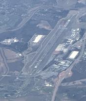
Asheville Regional Airport
Official FAA Data Effective 2025-12-25 0901Z
From the Flight Deck
VFR Chart of KAVL
Sectional Charts at SkyVector.com
IFR Chart of KAVL
Enroute Charts at SkyVector.com
Location Information for KAVL
Coordinates: N35°26.17' / W82°32.52'Located 09 miles S of Asheville, North Carolina on 900 acres of land. View all Airports in North Carolina.
Surveyed Elevation is 2163 feet MSL.
Operations Data
|
|
Airport Communications
| ATIS: | 120.2 |
|---|---|
| ASOS: | Tel. 828-202-3316 |
| ASHEVILLE TOWER: | 121.1 257.8 |
| ASHEVILLE GROUND: | 121.9 |
| ASHEVILLE APPROACH: | 124.65 ;080-299 125.8 ;300-079 269.575 ;300-079 351.8 ;080-299 |
| ASHEVILLE DEPARTURE: | 124.65 ;080-299 125.8 ;300-079 269.575 ;300-079 351.8 ;080-299 |
| IC: | 124.65 ;080-299 351.8 ;080-299 |
| CTAF: | 121.100 |
| UNICOM: | 122.950 |
| CLASS C: | 124.65 ;080-299 125.8 ;300-079 269.575 ;300-079 351.8 ;080-299 |
| EMERG: | 121.5 243.0 |
| ASHEVILLE DP: | 124.65 ;RWY 17 125.8 ;RWY 35 269.575 ;RWY 35 351.8 ;RWY 17 |
| AWOS-3 at FQD (29.7 E): | 118.275 828-287-6498 |
| AWOS-3PT at 24A (33.4 W): | 118.9 828-631-3389 |
| ATIS at GSP (36.1 SE): | 134.25 |
- COMM UNAVBL BLO 6000 FT EXCP BY RDU RADIO ON FREQ 122.3 (SUGARLOAF MOUNTAIN RCO) WHEN AVL APCH CTL CLSD.
- APCH/DEP SVC PRVDD BY ATLANTA ARTCC ON FREQS 132.625/353.625 (SUGARLOAF MOUNTAIN RCAG) WHEN APCH CTL CLSD.
Nearby Navigation Aids
|
| ||||||||||||||||||||||||||||||||||||||||||||||||||||||||||||
Runway 17/35
| Dimensions: | 8002 x 150 feet / 2439 x 46 meters | |
|---|---|---|
| Surface: | Asphalt / Grooved in Excellent Condition | |
| Weight Limits: | S-120, D-219, ST-404, DT-837
PCR VALUE: 440/F/A/X/T
| |
| Edge Lighting: | High Intensity | |
| Runway 17 | Runway 35 | |
| Coordinates: | N35°26.79' / W82°32.80' | N35°25.55' / W82°32.24' |
| Elevation: | 2163.9 | 2117.4 |
| Traffic Pattern: | Left | Right RWY 35 RIGHT TRAFFIC WHEN ATCT CLSD. |
| Runway Heading: | 160° True | 340° True |
| Declared Distances: | TORA:8002 TODA:8002 ASDA:8002 LDA:8002 | TORA:8002 TODA:8002 ASDA:8002 LDA:8002 |
| Markings: | Precision Instrument in good condition. | Precision Instrument in good condition. |
| Glide Slope Indicator | P4R (3.00° Glide Path Angle) | P4L (3.00° Glide Path Angle) |
| RVR Equipment | Touchdown Rollout | Touchdown Rollout |
| Approach Lights: | MALSR 1,400 Foot Medium-intensity Approach Lighting System with runway alignment indicator lights. | MALSR 1,400 Foot Medium-intensity Approach Lighting System with runway alignment indicator lights. |
| Centerline Lights: | Yes | Yes |
Services Available
| Fuel: | 100LL (blue), Jet-A |
|---|---|
| Transient Storage: | Hangars,Tiedowns |
| Airframe Repair: | MINOR |
| Engine Repair: | MINOR |
| Bottled Oxygen: | HIGH |
| Bulk Oxygen: | NONE |
| Other Services: | AIR FREIGHT SERVICES,CARGO HANDLING SERVICES,CHARTER SERVICE,PILOT INSTRUCTION,AIRCRAFT RENTAL |
Ownership Information
| Ownership: | Publicly owned | |
|---|---|---|
| Owner: | GREATER ASHEVILLE RGNL ARPT AUTH. | |
| 61 TERMINAL DR SUITE 1 | ||
| FLETCHER, NC 28732-9442 | ||
| 828-684-2226 | ||
| Manager: | LEW S. BLEIWEIS, A.A.E. | |
| 61 TERMINAL DRIVE; SUITE 1 | ||
| FLETCHER, NC 28731-9442 | ||
| 828-684-4577 | (828) 684-4577 OR EMERG CTC - (828) 209-5100. | |
Other Remarks
- FOR THE ASHEVILLE REGIONAL AIRPORT AIRCRAFT DIVERSIONS EMERGENCY CONTINGENCY PLAN AND FACILITY CONSTRAINTS CTC ARPT ADMIN AT 828-684-2226.
- FLOCKS OF MIGRATORY BIRDS ON AND INVOF ARPT.
- WHEN ATCT CLSD, FOR CD CTC ATLANTA ARTCC AT 770-210-7692.
- WHEN TWR CLSD, ACTVT MALSR RWY 17 & 35; PAPI RWYS 17 & 35; HIRLS RWY 17/35 - CTAF.
Weather Minimums
Instrument Approach Procedure (IAP) Charts
Departure Procedure (DP) Charts
Nearby Airports with Instrument Procedures
| ID | Name | Heading / Distance | ||
|---|---|---|---|---|
 |
KFQD | Rutherford County/Marchman Field Airport | 090° | 29.8 |
 |
24A | Jackson County Airport | 257° | 33.5 |
 |
KGSP | Greenville Spartanburg International Airport | 153° | 36.1 |
 |
KGMU | Greenville Downtown Airport | 164° | 36.5 |
 |
KLQK | Pickens County Airport | 191° | 38.3 |
 |
KGYH | Donaldson Field Airport | 168° | 41.4 |
 |
KSPA | Spartanburg Downtown Memorial/Simpson Field Airport | 137° | 42.4 |
 |
1A5 | Macon County Airport | 253° | 45.0 |
 |
KEHO | Shelby-Cleveland County Regional Airport | 102° | 47.4 |
 |
KGCY | Greeneville Municipal Airport | 343° | 47.4 |
 |
KCEU | Oconee County Regional Airport | 200° | 48.8 |
 |
KMRN | Foothills Regional Airport | 062° | 51.0 |


Comments
Signature, OUCH
May 2017 - Signature charged us $45 to park a cherokee for 3 hours while we got lunch. That's a bit steep and by a bit I mean WTF.
Good to know about Signature
Thats great information to have. I will keep that in mind. Did they give you a club car for the $45 parking?
Nick breeze