Login
Register


H92
Hominy Municipal Airport
Official FAA Data Effective 2026-02-19 0901Z
Chart Supplement

VFR Chart of H92
Sectional Charts at SkyVector.com
IFR Chart of H92
Enroute Charts at SkyVector.com
Location Information for H92
Coordinates: N36°26.56' / W96°23.23'Located 02 miles N of Hominy, Oklahoma on 120 acres of land. View all Airports in Oklahoma.
Estimated Elevation is 825 feet MSL.
Operations Data
|
|
Airport Communications
| CTAF: | 122.900 |
|---|---|
| AWOS-3T at OWP (19.7 SE): | 118.325 918-246-2635 |
| ASOS at BVO (26.4 NE): | 132.675 918-336-2070 |
| D-ATIS at TUL (28.3 SE): | 124.9 |
Nearby Navigation Aids
|
| ||||||||||||||||||||||||||||||||||||||||||||||||||||||||||||


Runway 17/35
| Dimensions: | 3210 x 60 feet / 978 x 18 meters | |
|---|---|---|
| Surface: | Asphalt in Good Condition | |
| Weight Limits: | S-8 | |
| Edge Lighting: | Medium Intensity | |
| Runway 17 | Runway 35 | |
| Coordinates: | N36°26.83' / W96°23.23' | N36°26.30' / W96°23.23' |
| Elevation: | 819.0 | 820.0 |
| Traffic Pattern: | Left | Left |
| Runway Heading: | 180° True | 0 |
| Displaced Threshold: | 180 Feet | 180 Feet |
| Markings: | Basic in good condition. | Basic in good condition. |
| Glide Slope Indicator | P4L | P4L |
| Obstacles: | 24 ft Trees 692 ft from runway, 97 ft left of center | 22 ft Trees 400 ft from runway, 107 ft left of center |
Services Available
| Fuel: | 100LL (blue) |
|---|---|
| Transient Storage: | Tiedowns |
| Airframe Repair: | NONE |
| Engine Repair: | NONE |
| Bottled Oxygen: | NONE |
| Bulk Oxygen: | NONE |
Ownership Information
| Ownership: | Publicly owned | |
|---|---|---|
| Owner: | CITY OF HOMINY | |
| 219 W. 1ST ST., PO BOX 219 | ||
| HOMINY, OK 74035 | ||
| 918-885-2164 | ||
| Manager: | JIMMIE RATLIFF | CITY MGR. |
| 219 W. 1ST ST., PO BOX 219 | ||
| HOMINY, OK 74035 | ||
| 918-885-2164 | ||
Other Remarks
- ULTRALIGHT ACTIVITY ON & INVOF ARPT.
- FOR CD CTC KANSAS CITY ARTCC AT 913-254-8508.
- 0LL FUEL AVBL 24 HRS SELF SERVICE WITH CREDIT CARD.
- ACTVT MIRL RY 17/35 - CTAF.
Nearby Airports with Instrument Procedures
| ID | Name | Heading / Distance | ||
|---|---|---|---|---|
 |
KOWP | William R Pogue Municipal Airport | 144° | 19.7 |
|
KBVO | Bartlesville Municipal Airport | 043° | 26.4 |
|
KTUL | Tulsa International Airport | 121° | 28.3 |
|
KRVS | Tulsa Riverside Airport | 140° | 31.1 |
|
KCUH | Cushing Municipal Airport | 212° | 35.0 |
|
KSWO | Stillwater Regional Airport | 243° | 37.8 |
|
3F7 | Jones Memorial Airport | 182° | 38.1 |
|
KPNC | Ponca City Regional Airport | 296° | 38.5 |
|
F22 | Perry Municipal Airport | 265° | 43.2 |
|
KGCM | Claremore Regional Airport | 101° | 44.9 |
|
KCQB | Chandler Regional Airport | 206° | 47.9 |
|
KBKN | Blackwell-Tonkawa Municipal Airport | 291° | 49.9 |
Airport Images
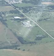
By: Big Orange Bird


