Login
Register


GWB
Auburn/Dekalb Exec Airport
Official FAA Data Effective 2025-12-25 0901Z
Chart Supplement

VFR Chart of KGWB
Sectional Charts at SkyVector.com
IFR Chart of KGWB
Enroute Charts at SkyVector.com
Location Information for KGWB
Coordinates: N41°18.43' / W85°3.63'Located 03 miles S of Auburn, Indiana on 695 acres of land. View all Airports in Indiana.
Surveyed Elevation is 880 feet MSL.
Operations Data
|
|
Airport Communications
| AWOS-3P: | 124.15 Tel. 260-925-8225 |
|---|---|
| FORT WAYNE APPROACH: | 127.2 ;SW/NW OF ACTIVE RWY 132.15 ;SE/NE OF ACTIVE RWY 282.325 ;SE/NE OF ACTIVE RWY 284.6 ;SW/NW OF ACTIVE RWY |
| FORT WAYNE DEPARTURE: | 127.2 ;SW/NW OF ACTIVE RWY 132.15 ;SE/NE OF ACTIVE RWY 282.325 ;SE/NE OF ACTIVE RWY 284.6 ;SW/NW OF ACTIVE RWY |
| IC: | 127.2 ;SW/NW OF ACTIVE RWY |
| CLEARANCE DELIVERY: | 126.6 |
| UNICOM: | 123.000 |
| CLASS C: | 282.325 ;SE/NE OF ACTIVE RWY |
| CTAF: | 123.000 |
| AWOS-3 at SMD (10.7 SW): | 124.55 260-490-4030 |
| AWOS-3P at C62 (13.3 NW): | 119.925 260-347-2967 |
| AWOS-3 at ANQ (20.0 N): | 118.175 260-668-5630 |
- APCH CTL SECTORIZATION BASED UPON FORT WAYNE RWY USAGE.
Nearby Navigation Aids
|
| ||||||||||||||||||||||||||||||||||||||||||||||||||||||||||||


Runway 09/27
RWY 27 CALM WIND RWY. | ||
| Dimensions: | 7106 x 100 feet / 2166 x 30 meters | |
|---|---|---|
| Surface: | Asphalt / Grooved in Good Condition | |
| Weight Limits: | S-60, D-90, ST-120 | |
| Edge Lighting: | Medium Intensity | |
| Runway 09 | Runway 27 | |
| Coordinates: | N41°18.42' / W85°4.41' | N41°18.44' / W85°2.86' |
| Elevation: | 870.4 | 874.8 |
| Traffic Pattern: | Left | Left |
| Runway Heading: | 89° True | 269° True |
| Displaced Threshold: | 700 Feet | 750 Feet |
| Declared Distances: | LDA:6406 | LDA:6356 |
| Markings: | Non-Precision Instrument in fair condition. | Precision Instrument in fair condition. |
| Glide Slope Indicator | P4L (3.00° Glide Path Angle) | P4L (3.00° Glide Path Angle) |
| Approach Lights: | MALSR 1,400 Foot Medium-intensity Approach Lighting System with runway alignment indicator lights. | |
| REIL: | Yes | Yes |
Services Available
| Fuel: | 100LL (blue), Jet A+ |
|---|---|
| Transient Storage: | Hangars,Tiedowns |
| Airframe Repair: | MAJOR |
| Engine Repair: | MAJOR |
| Bottled Oxygen: | HIGH |
| Bulk Oxygen: | HIGH |
| Other Services: | CROP DUSTING SERVICES,AIR AMBULANCE SERVICES,CARGO HANDLING SERVICES,CHARTER SERVICE,PILOT INSTRUCTION,AIRCRAFT RENTAL |
Ownership Information
| Ownership: | Publicly owned | |
|---|---|---|
| Owner: | DE KALB COUNTY AIRPORT AUTHORITY | |
| 2710 CR 60 SUITE 200 | ||
| AUBURN, IN 46706 | ||
| 260-927-8876 | ||
| Manager: | RUSS COUCHMAN | |
| 2710 CR 60 SUITE 200 | ||
| AUBURN, IN 46706 | ||
| 260-927-8876 | ||
Other Remarks
- FOR CD CTC CHICAGO ARTCC AT 630-906-8921.
- WINTER SN REMOVAL OPS. FICON UNMNT WHEN UNATNDD; AFT HR - AMGR.
- MIRL RWY 09/27 PRESET LOW INTST SS-SR; TO INCR INTST & ACTVT MALSR RWY 27; REIL RWY 09 & 27; MIRL RWY 09/27 - CTAF. PAPI RWY 09 & 27 OPRS CONSLY.
Weather Minimums
Instrument Approach Procedure (IAP) Charts

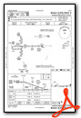


Nearby Airports with Instrument Procedures
| ID | Name | Heading / Distance | ||
|---|---|---|---|---|
 |
KSMD | Smith Field Airport | 203° | 10.7 |
|
C62 | Kendallville Municipal Airport | 317° | 13.4 |
|
KANQ | Tri-State Steuben County Airport | 357° | 20.0 |
|
KFWA | Fort Wayne International Airport | 197° | 20.6 |
|
0G6 | Williams County Airport | 068° | 26.8 |
|
KDFI | Defiance Memorial Airport | 086° | 28.6 |
|
KHHG | Huntington Municipal Airport | 213° | 32.6 |
|
KVNW | Van Wert County Airport | 142° | 33.6 |
|
KIRS | Kirsch Municipal Airport | 330° | 34.8 |
|
KASW | Warsaw Municipal Airport | 267° | 35.3 |
|
KGSH | Goshen Municipal Airport | 291° | 35.6 |
|
KOEB | Branch County Memorial Airport | 000° | 37.6 |
Fuel Providers

Airport Images
Do you have a recent image of this airport? Upload it here!


