Login
Register


SMD
Smith Field Airport
Official FAA Data Effective 2025-12-25 0901Z
Chart Supplement

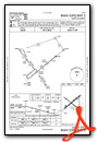
VFR Chart of KSMD
Sectional Charts at SkyVector.com
IFR Chart of KSMD
Enroute Charts at SkyVector.com
Location Information for KSMD
Coordinates: N41°8.60' / W85°9.17'Located 04 miles N of Fort Wayne, Indiana on 234 acres of land. View all Airports in Indiana.
Surveyed Elevation is 835 feet MSL.
Operations Data
|
|
Airport Communications
| AWOS-3: | 124.55 Tel. 260-490-4030 |
|---|---|
| FORT WAYNE APPROACH: | 127.2 ;SW/NW OF ACTIVE RWY 132.15 ;SE/NE OF ACTIVE RWY 282.325 ;SE/NE OF ACTIVE RWY 284.6 ;SW/NW OF ACTIVE RWY |
| FORT WAYNE DEPARTURE: | 127.2 ;SW/NW OF ACTIVE RWY 132.15 ;SE/NE OF ACTIVE RWY 282.325 ;SE/NE OF ACTIVE RWY 284.6 ;SW/NW OF ACTIVE RWY |
| IC: | 127.2 ;SW/NW OF ACTIVE RWY |
| CTAF: | 122.800 |
| UNICOM: | 122.800 |
| CLASS C: | 282.325 ;SE/NE OF ACTIVE RWY |
| ASOS at FWA (10.1 S): | 121.25 260-209-0224 |
| ATIS at FWA (10.1 S): | 121.25 |
| AWOS-3P at GWB (10.8 NE): | 124.15 260-925-8225 |
- APCH CTL SECTORIZATION BASED UPON FORT WAYNE RWY USAGE.
Nearby Navigation Aids
|
| ||||||||||||||||||||||||||||||||||||||||||||||||||||||||||||


Runway 05/23
RWY 23 CALM WIND RWY. | ||
| Dimensions: | 3126 x 100 feet / 953 x 30 meters | |
|---|---|---|
| Surface: | Asphalt in Good Condition | |
| Weight Limits: | D-40 | |
| Edge Lighting: | Medium Intensity | |
| Runway 05 | Runway 23 | |
| Coordinates: | N41°8.45' / W85°9.43' | N41°8.78' / W85°8.90' |
| Elevation: | 827.0 | 828.0 |
| Traffic Pattern: | Left | Left |
| Runway Heading: | 51° True | 231° True |
| Displaced Threshold: | 201 Feet | 91 Feet |
| Markings: | Non-Precision Instrument in good condition. | Non-Precision Instrument in good condition. |
| Glide Slope Indicator | P2L (4.00° Glide Path Angle) PAPI RSTRD BYD 7 DEGS LEFT & RIGHT OF CNTRLN. | P2L (3.05° Glide Path Angle) PAPI UNUSBL BYD 7 DEGS LEFT & RIGHT OF CNTRLN. |
| Obstacles: | 10 ft Crops 200 ft from runway 10 FT CROPS 65 FT FM RWY END & 90 FT E & 115 FT W. |
15 ft Road 200 ft from runway, 175 ft right of center 15 FT ROAD 185 FT FM RWY END 175 FT R. |
Runway 13/31
75 FT CROPS EACH SIDE OF CNTRLN. | ||
| Dimensions: | 2922 x 60 feet / 891 x 18 meters | |
|---|---|---|
| Surface: | Asphalt in Excellent Condition | |
| Weight Limits: | D-40 | |
| Edge Lighting: | Medium Intensity | |
| Runway 13 | Runway 31 | |
| Coordinates: | N41°8.74' / W85°9.42' | N41°8.44' / W85°8.92' |
| Elevation: | 832.4 | 825.4 |
| Traffic Pattern: | Left | Left |
| Runway Heading: | 128° True | 308° True |
| Displaced Threshold: | 299 Feet | 101 Feet |
| Markings: | Non-Precision Instrument in good condition. | Non-Precision Instrument in good condition. |
| Obstacles: | 60 ft Tree 1171 ft from runway, 270 ft right of center APCH RATIO 24:1 AT DTHR. 10 FT CROPS 60 FT FM RWY END |
15 ft Road 200 ft from runway, 200 ft left of center 15 FT ROAD 215 FT FM RWY END 185 FT L. |
Services Available
| Fuel: | 100LL (blue), Jet-A |
|---|---|
| Transient Storage: | Tiedowns |
| Airframe Repair: | MAJOR |
| Engine Repair: | MAJOR |
| Bottled Oxygen: | NOT AVAILABLE |
| Bulk Oxygen: | NOT AVAILABLE |
| Other Services: | PILOT INSTRUCTION,AIRCRAFT RENTAL |
Ownership Information
| Ownership: | Publicly owned | |
|---|---|---|
| Owner: | FT WAYNE ALLEN CO APT ATHRTY | |
| 3801 W FERGUSON ROAD-RM 209 | ||
| FT WAYNE, IN 46809 | ||
| 260-747-4146 | ||
| Manager: | SCOTT D. HINDERMAN, A.A.E. | |
| 3801 WEST FERGUSON ROAD, STE. 209 | ||
| FORT WAYNE, IN 46809 | ||
| 260-747-4146 | ||
Other Remarks
- COND UNMNT NOV-MAR 1900-0700.
- COLD TEMPERATURE AIRPORT. ALTITUDE CORRECTION REQUIRED AT OR BELOW -21C.
- 100 FT FLD LGTS 0.5 NM E.
- BIRDS ON & INVOF ARPT.
- FOR CD CTC CHICAGO ARTCC AT 630-906-8921.
- 0LL SELF SVC AVBL.
- ACTVT PAPI RWY 05; MIRL RWY 05/23 & 13/31 - CTAF.
Weather Minimums
Instrument Approach Procedure (IAP) Charts


Nearby Airports with Instrument Procedures
| ID | Name | Heading / Distance | ||
|---|---|---|---|---|
 |
KFWA | Fort Wayne International Airport | 191° | 10.1 |
|
KGWB | Auburn/Dekalb Exec Airport | 023° | 10.7 |
|
C62 | Kendallville Municipal Airport | 346° | 20.3 |
|
KHHG | Huntington Municipal Airport | 218° | 22.2 |
|
KVNW | Van Wert County Airport | 123° | 29.9 |
|
KANQ | Tri-State Steuben County Airport | 005° | 29.9 |
|
KASW | Warsaw Municipal Airport | 284° | 32.1 |
|
KDFI | Defiance Memorial Airport | 070° | 34.8 |
|
0G6 | Williams County Airport | 056° | 35.1 |
|
KGSH | Goshen Municipal Airport | 308° | 37.0 |
|
KIWH | Wabash Municipal Airport | 232° | 37.2 |
|
C03 | Nappanee Municipal Airport | 297° | 39.8 |
Airport Images
Do you have a recent image of this airport? Upload it here!


