Login
Register


IWH
Wabash Municipal Airport
Official FAA Data Effective 2026-02-19 0901Z
Chart Supplement

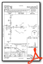
VFR Chart of KIWH
Sectional Charts at SkyVector.com
IFR Chart of KIWH
Enroute Charts at SkyVector.com
Location Information for KIWH
Coordinates: N40°45.72' / W85°47.92'Located 03 miles SE of Wabash, Indiana on 243 acres of land. View all Airports in Indiana.
Surveyed Elevation is 795 feet MSL.
Operations Data
|
|
Airport Communications
| GRISSOM APPROACH: | 121.05 338.275 |
|---|---|
| GRISSOM DEPARTURE: | 121.05 338.275 |
| CTAF: | 122.800 |
| UNICOM: | 122.800 |
| AWOS-3PT at HHG (16.5 E): | 126.575 260-454-1927 |
| AWOS-3 at MZZ (17.2 S): | 108.6 765-674-1317 |
| ATIS at GUS (17.5 W): | 270.8 |
- APCH/DEP SVC PRVDD BY CHICAGO ARTCC ON FREQS 121.05 (REMOTED FROM GRISSOM) WHEN GRISSOM APCH CTL CLSD.
Nearby Navigation Aids
|
| ||||||||||||||||||||||||||||||||||||||||||||||||||||||||||||


Runway 09/27
| Dimensions: | 4401 x 75 feet / 1341 x 23 meters | |
|---|---|---|
| Surface: | Concrete / Grooved in Fair Condition | |
| Weight Limits: | S-27 | |
| Edge Lighting: | Medium Intensity | |
| Runway 09 | Runway 27 | |
| Coordinates: | N40°45.66' / W85°48.48' | N40°45.67' / W85°47.52' |
| Elevation: | 793.4 | 791.7 |
| Traffic Pattern: | Left ULTRALIGHT USE R TFC PAT. |
Left |
| Runway Heading: | 89° True | 269° True |
| Markings: | Non-Precision Instrument in fair condition. | Non-Precision Instrument in fair condition. |
| Glide Slope Indicator | P2L (3.00° Glide Path Angle) | P2L (3.00° Glide Path Angle) |
| REIL: | Yes | Yes |
| Obstacles: | 15 ft Road 500 ft from runway +54 FT UNLGTD PLINE 1275 FT FM RWY END; 19:1 OBSTN CLNC SLOPE. |
53 ft Trees 1380 ft from runway |
Runway 18/36
| Dimensions: | 1940 x 60 feet / 591 x 18 meters | |
|---|---|---|
| Surface: | Asphalt in Good Condition | |
| Weight Limits: | S-27 | |
| Edge Lighting: | Low Intensity | |
| Runway 18 | Runway 36 | |
| Coordinates: | N40°46.00' / W85°47.76' | N40°45.68' / W85°47.75' |
| Elevation: | 790.4 | 792.8 |
| Runway Heading: | 179° True | 359° True |
| Displaced Threshold: | 403 Feet | |
| Markings: | Basic in fair condition. | Basic in fair condition. |
| Obstacles: | 84 ft Trees 1440 ft from runway APCH RATIO 20:1 TO DTHR. |
60 ft Trees 650 ft from runway, 100 ft right of center |
Services Available
| Fuel: | 100LL (blue), Jet-A |
|---|---|
| Transient Storage: | Tiedowns |
| Airframe Repair: | NOT AVAILABLE |
| Engine Repair: | NOT AVAILABLE |
| Bottled Oxygen: | NOT AVAILABLE |
| Bulk Oxygen: | NOT AVAILABLE |
| Other Services: | AIR AMBULANCE SERVICES,CHARTER SERVICE,PILOT INSTRUCTION,AIRCRAFT RENTAL |
Ownership Information
| Ownership: | Publicly owned | |
|---|---|---|
| Owner: | WABASH BOAC | |
| 283 W. 400 S. | ||
| WABASH, IN 46992 | ||
| 260-563-4705 | ||
| Manager: | JONATHAN DERBY | |
| 283 W. 400 S. | ||
| WABASH, IN 46992 | ||
| 260-563-4705 | ||
Other Remarks
- FOR CD CTC CHICAGO ARTCC AT 630-906-8921.
- 0LL AVBL H24 WITH CREDIT CARD.
- ACTVT REIL RWY 09 & 27 - CTAF. MIRL RWY 09/27 PRESET LOW INTST; INCR INTST - CTAF.
Weather Minimums

Instrument Approach Procedure (IAP) Charts

Nearby Airports with Instrument Procedures
| ID | Name | Heading / Distance | ||
|---|---|---|---|---|
 |
I76 | Peru Municipal Airport | 275° | 15.9 |
|
KHHG | Huntington Municipal Airport | 070° | 16.5 |
|
KMZZ | Marion Municipal - Mckinney Field Airport | 161° | 17.2 |
|
KGUS | Grissom Arb Airport | 247° | 17.5 |
|
KOKK | Kokomo Municipal Airport | 220° | 18.4 |
|
KRCR | Fulton County Airport | 316° | 25.2 |
|
KGGP | Logansport/Cass County Airport | 263° | 26.4 |
|
KFWA | Fort Wayne International Airport | 064° | 30.4 |
|
KASW | Warsaw Municipal Airport | 356° | 30.8 |
|
KMIE | Delaware County Regional Airport | 149° | 36.2 |
|
KSMD | Smith Field Airport | 051° | 37.2 |
|
5I4 | Sheridan Airport | 208° | 39.9 |
Airport Images

By: 2flaps


