Login
Register


HTW
Lawrence County Airpark Airport
Official FAA Data Effective 2026-02-19 0901Z
Chart Supplement

VFR Chart of KHTW
Sectional Charts at SkyVector.com
IFR Chart of KHTW
Enroute Charts at SkyVector.com
Location Information for KHTW
Coordinates: N38°25.15' / W82°29.69'Located 02 miles W of Chesapeake/Huntington Wva, Ohio on 86 acres of land. View all Airports in Ohio.
Surveyed Elevation is 567 feet MSL.
Operations Data
|
|
Airport Communications
| CTAF: | 122.700 |
|---|---|
| UNICOM: | 122.700 |
| ASOS at HTS (4.3 SW): | 681-432-1499 |
| ATIS at HTS (4.3 SW): | 125.2 |
| AWOS-3PT at DWU (14.0 NW): | 132.425 606-836-2682 |
Nearby Navigation Aids
|
| ||||||||||||||||||||||||||||||||||||||||||||||||||||||||||||


Runway 08/26
| Dimensions: | 2998 x 70 feet / 914 x 21 meters | |
|---|---|---|
| Surface: | Asphalt in Excellent Condition | |
| Edge Lighting: | Medium Intensity | |
| Runway 08 | Runway 26 | |
| Coordinates: | N38°25.08' / W82°29.99' | N38°25.21' / W82°29.39' |
| Elevation: | 554.9 | 564.6 |
| Traffic Pattern: | Left | Left |
| Runway Heading: | 75° True | 255° True |
| Displaced Threshold: | 172 Feet | |
| Markings: | Basic in good condition. | Basic in good condition. |
| Obstacles: | 56 ft Trees 619 ft from runway, 125 ft right of center APCH SLP 14:1 TO DTHR OVR +56 FT TREE, 619 FT DIST, 125 FT R. +10 FT ROAD, 0 FT DIST, 45 FT R; +12-20 FT TREES, 0-75 FT DIST, 85 FT R; +10-15 FT BRUSH, 85-150 FT DIST, 90 FT L. |
+1-8 FT BRUSH & VEGETATION, 63 FT DIST EXTDG TO DROP-OFF, 125 FT L/R. |
Services Available
| Fuel: | 100LL (blue) |
|---|---|
| Transient Storage: | Tiedowns |
| Airframe Repair: | MINOR |
| Engine Repair: | MINOR |
| Bottled Oxygen: | NONE |
| Bulk Oxygen: | NONE |
| Other Services: | PILOT INSTRUCTION,AIRCRAFT RENTAL |
Ownership Information
| Ownership: | Publicly owned | |
|---|---|---|
| Owner: | LAWRENCE CO BOARD OF COMMISSIONERS | |
| COURTHOUSE, 111 S 4TH ST | ||
| IRONTON, OH 45638-1522 | ||
| 740-533-4300 | ||
| Manager: | BILL NENNI | |
| 304 N 7TH ST | ||
| IRONTON, OH 45638-1468 | ||
| 740-532-3309 | ||
Other Remarks
- FOR CD CTC HUNTINGTON ATCT AT 304-453-2490.
- 0LL 100LL AVBL H24 SELF SVC VIA CREDIT CARD.
- ACTVT MIRL RWY 08/26 - CTAF.
Nearby Airports with Instrument Procedures
| ID | Name | Heading / Distance | ||
|---|---|---|---|---|
 |
KHTS | Tri-State/Milton J Ferguson Field Airport | 225° | 4.3 |
|
12V | Ona Airpark Airport | 084° | 13.9 |
|
KDWU | Ashland Regional Airport | 305° | 14.0 |
|
KGAS | Gallia-Meigs Regional Airport | 031° | 29.4 |
|
KPMH | Greater Portsmouth Regional Airport | 326° | 30.2 |
|
KJRO | James A Rhodes Airport | 353° | 33.9 |
|
3I2 | Mason County Airport | 031° | 35.1 |
|
KSJS | Big Sandy Regional Airport | 189° | 40.6 |
|
KCRW | West Virginia International Yeager Airport | 093° | 42.6 |
|
6L4 | Logan County Airport | 140° | 43.5 |
|
I18 | Jackson County Airport | 045° | 44.1 |
|
KEBD | Southern West Virginia Regional Airport | 158° | 47.6 |
Airport Images
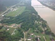
By: jderosa


