Login
Register


I54
Mad River Airpark Airport
Official FAA Data Effective 2025-11-27 0901Z
Chart Supplement

VFR Chart of I54
Sectional Charts at SkyVector.com
IFR Chart of I54
Enroute Charts at SkyVector.com
Location Information for I54
Coordinates: N40°1.20' / W83°49.71'Located 01 miles NE of Tremont City, Ohio on 35 acres of land. View all Airports in Ohio.
Estimated Elevation is 958 feet MSL.
Operations Data
|
|
Airport Communications
| COLUMBUS APPROACH: | 134.45 294.5 |
|---|---|
| COLUMBUS DEPARTURE: | 134.45 294.5 |
| IC: | 294.5 |
| UNICOM: | 123.000 |
| CTAF: | 123.000 |
| AWOS-3 at I74 (7.6 NE): | 118.325 937-484-5863 |
| AWOS-3PT at SGH (11.1 S): | 134.975 937-324-4532 |
| ATIS at FFO (15.4 SW): | 269.9 |
Nearby Navigation Aids
|
| ||||||||||||||||||||||||||||||||||||||||||||||||||||||||||||


Runway 09/27
| Dimensions: | 3405 x 110 feet / 1038 x 34 meters MID 50 FT MOWED. | |
|---|---|---|
| Surface: | Turf in Poor Condition | |
| Edge Lighting: | Non-Standard NSTD LIRL DUE TO ONLY 2165 FT LGTD BTN DTHRS. | |
| Runway 09 | Runway 27 | |
| Coordinates: | N40°1.19' / W83°50.08' | N40°1.22' / W83°49.35' |
| Elevation: | 955.0 | 955.0 |
| Traffic Pattern: | Left | Left |
| Displaced Threshold: | 340 Feet | 900 Feet |
| Obstacles: | 25 ft Pole 0 ft from runway, 60 ft right of center APCH SLP 9:1 TO DTHR OVR 201 FT WOODED HILL, 1955 FT DIST. |
15 ft Pole 0 ft from runway, 60 ft right of center APCH SLP 10:1 TO DTHR OVR 109 FT TREES, 1100 FT DIST, 125 FT R. |
Services Available
| Fuel: | NONE |
|---|---|
| Transient Storage: | Hangars,Tiedowns |
| Airframe Repair: | NONE |
| Engine Repair: | NONE |
| Bottled Oxygen: | NONE |
| Bulk Oxygen: | NONE |
Ownership Information
| Ownership: | Privately Owned | |
|---|---|---|
| Owner: | MAD RIVER FIELD, LLC | |
| 6488 UPPER VALLEY PIKE | ||
| URBANA, OH 43078-9100 | ||
| 618-351-9768 | ||
| Manager: | JEREMIAH BROWN | |
| 6488 UPPER VALLEY PIKE | ||
| URBANA, OH 43078-9100 | ||
| 618-351-9768 | ||
Other Remarks
- FOR CD CTC COLUMBUS APCH AT 614-338-8537.
- WEST 340 FT & EAST 900 FT NOT MKD; ONLY 2560 FT MKD WITH WHITE CONES; DTHR MKD WITH ONE CONE & GREEN LGT EACH SIDE OF RWY.
- WEST 340 FT & EAST 900 FT NOT MKD; ONLY 2560 FT MKD WITH WHITE CONES; DTHR MKD WITH ONE CONE & GREEN LGT EACH SIDE OF RWY.
- ACTVT NSTD LIRL RWY 09/27 - 122.8.
Nearby Airports with Instrument Procedures
| ID | Name | Heading / Distance | ||
|---|---|---|---|---|
 |
I74 | Grimes Field Airport | 026° | 7.6 |
|
KSGH | Springfield/Beckley Municipal Airport | 182° | 10.8 |
|
KFFO | Wright-Patterson AFB Airport | 220° | 15.4 |
|
KUYF | Madison County Airport | 107° | 17.7 |
|
KDAY | James M Cox Dayton International Airport | 248° | 19.4 |
|
KSCA | Sidney Municipal Airport | 312° | 19.8 |
|
KEDJ | Bellefontaine Regional Airport | 001° | 21.1 |
|
KGDK | Greene County/Lewis A Jackson Regional Airport | 201° | 21.2 |
|
I17 | Piqua/Hartzell Field Airport | 291° | 23.7 |
|
KMRT | Union County Airport | 060° | 25.1 |
|
3I7 | Dayton/Phillipsburg Airport | 256° | 27.1 |
|
I73 | Moraine Air Park Airport | 223° | 27.8 |
Airport Images
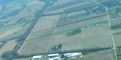
By: tshiverd
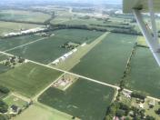
By: btracy62


